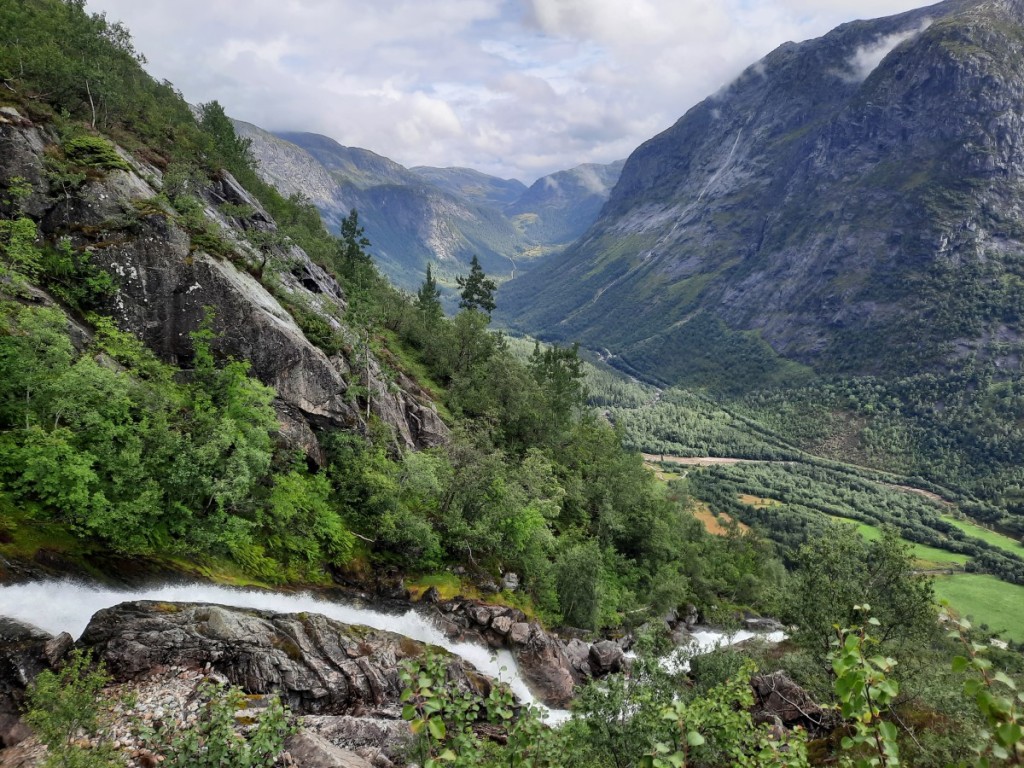
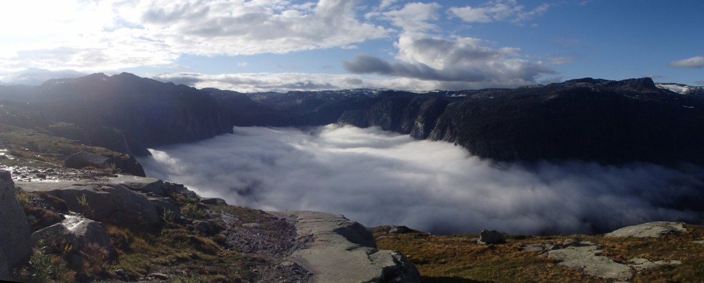
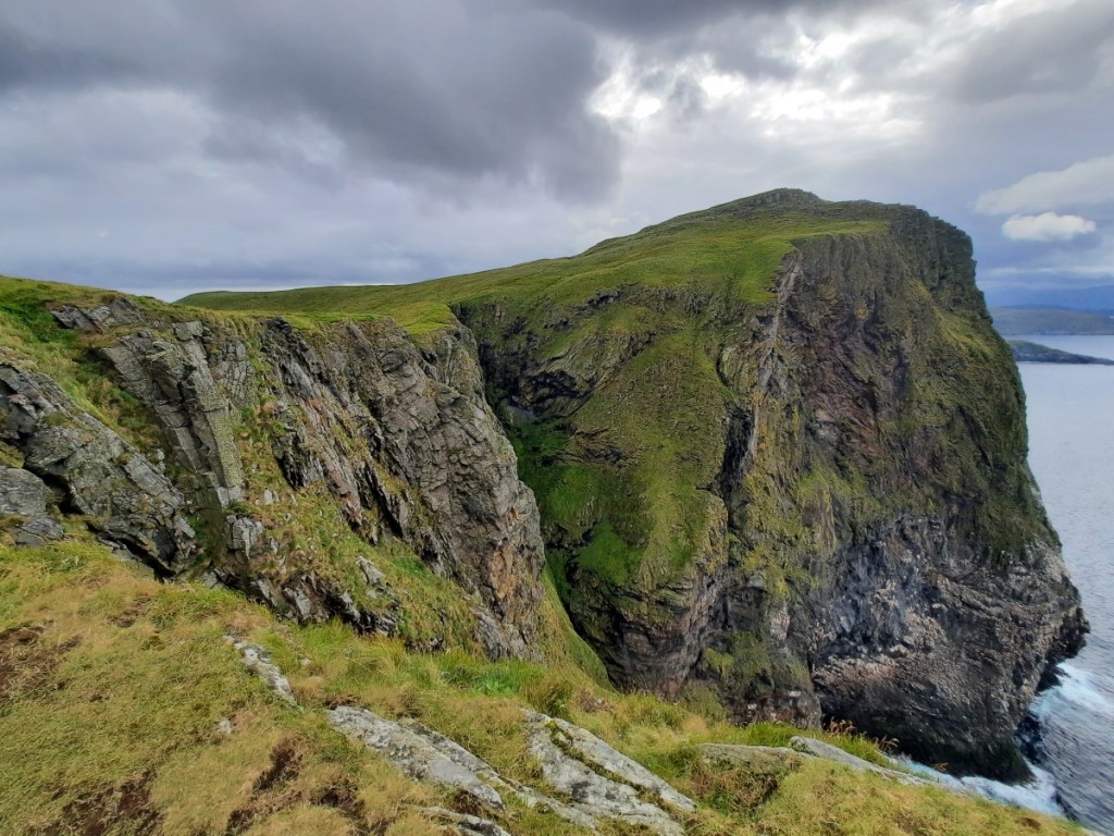
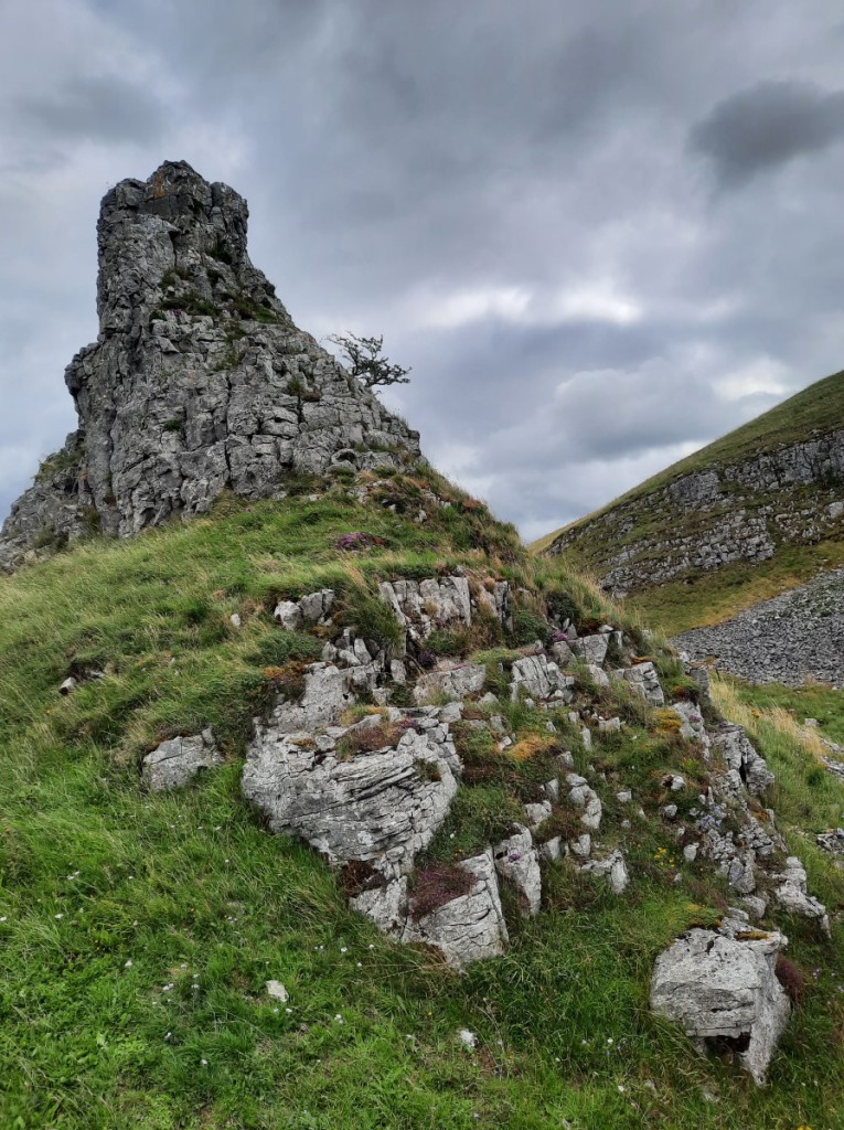
Four weeks after their wedding, the new Mr and Mrs Livesey came down to visit me in Derbyshire for the Saturday and Sunday of the May Day weekend. We met mid-morning on Saturday in Earl Sterndale for a walk over the distinctive “Dragon’s Back” hills. I defined a route that would save the summits for the second half, taking a more northerly (but less scenic) outward route from the village. Dowel Dale gave some good views of Chrome Hill though, and we crossed a very pretty arch bridge over the infant River Dove on the ancient byway between Leycote and Tenterhill.
Looking over Dowel Dale to Chrome HillCrossing the River Dove
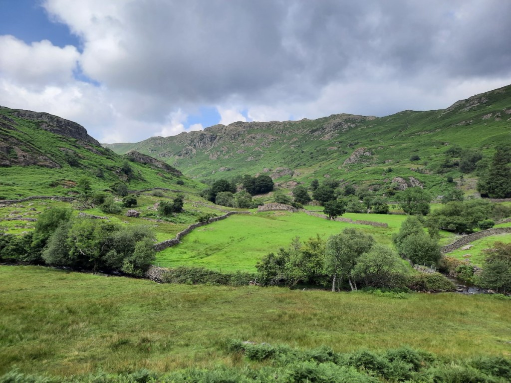
We continued down the very quiet valley of Hollinsclough, pausing for lunch in a pretty spot overlooking Hollins Hill. Then we ascended the ridge of Hollins Hill before traversing the crests of the more popular Chrome Hill and Parkhouse Hill – all made possible by permissive paths – to return to Earl Sterndale. These hills have become much busier since the pandemic and it was sad to see how eroded the small path over Parkhouse is getting. Route map: https://www.plotaroute.com/route/2612693
Chrome Hill and Parkhouse Hill, from HollinscloughParkhouse Hill, from the descent of Chrome HillLooking back to Chrome Hill, from Parkhouse Hill
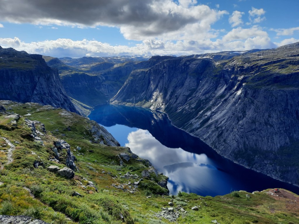
On the Sunday, the plan had been for Ruth and me to tackle the second of this year’s Peak Raid MapRun events. However, I had picked up a knee injury running the Shakespeare Half Marathon (in Stratford-upon-Avon) two weeks prior, and exacerbated it by running the first Peak Raid course at Monyash the following weekend, and did not feel able to run. I therefore kept Josh company on a walk, aiming to intercept Ruth a couple of times on her run.
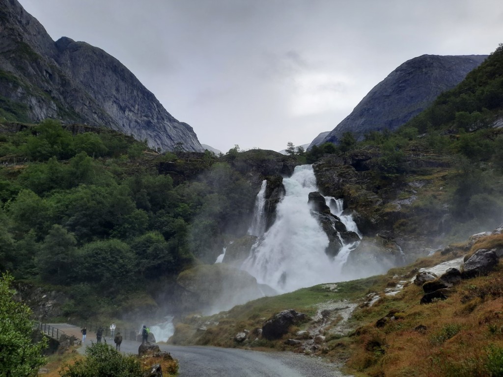
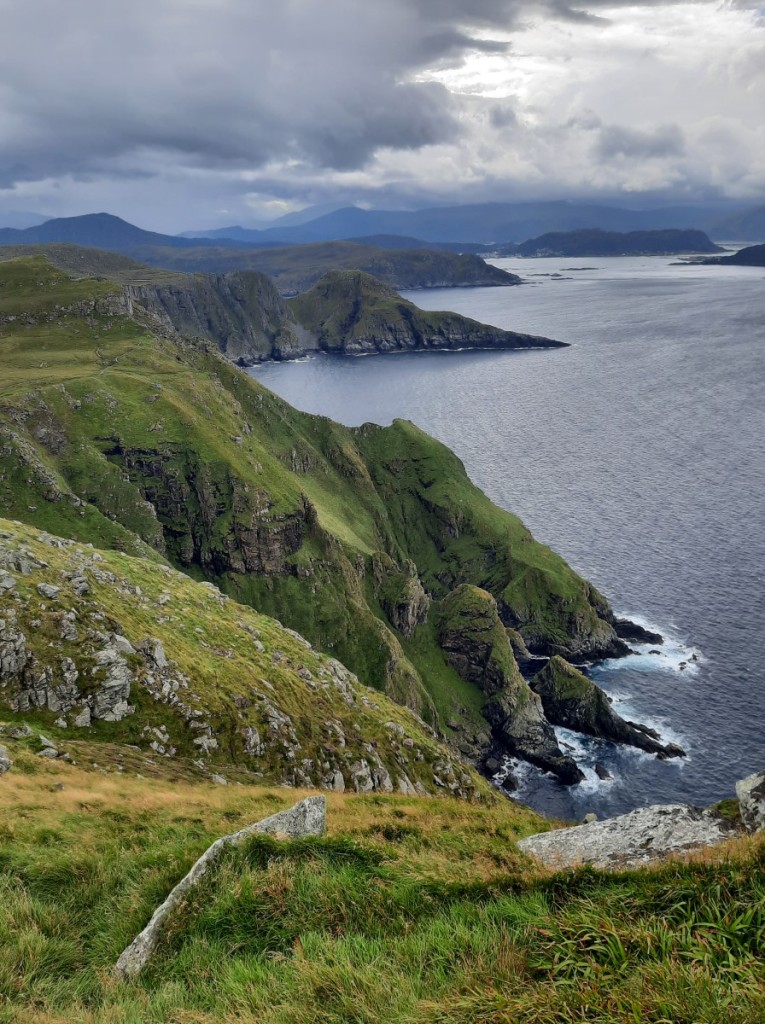
The MapRun and our walk started in the village of Wetton. We started by heading to the clifftop above Thor’s Cave – which I don’t think I had visited before – for great views up and down the Manifold Valley. Then we made a brief visit to the cave itself (overcrowded!) before dropping down into the valley bottom.
The Manifold Valley, as seen from above Thor’s CaveLooking back up to Thor’s Cave
We headed up the Manifold Trail a bit, then ascended the unnamed valley on the north side of Wetton Hill, and climbed up steep grassy slopes to reach the westernmost summit a little before Ruth passed by (she had taken a longer route over Ecton Hill). We continued over the main summit then looped back towards Wetton to meet Ruth again on her way back in from the east. Route map: https://www.plotaroute.com/route/2612698
Josh below Wetton HillRuth on Wetton Hill
We had lunch on a bench by the village green, then headed back to Hilton, from where Ruth and Josh soon set off back home. There are a few more photos on Google, here.
Ruth and Josh were married in St Mark’s Church, Natland, followed by an afternoon reception in the village hall with music by Kendal Concert Band, and a smaller evening reception, with meal and ceilidh, at Melmerby Village Hall.
St Mark’s Church, early on wedding morning. Peter’s clarinet solo, during the signing of the registersThe happy couple, heading out of the churchDad and Polly, Tim and MumJosh and Ruth, going to see the bandDinner in Melmerby
As usual, I took a trip to the Highlands for the long Easter weekend, this year a solo trip staying in hostels. I travelled up as far as Mum and Dad’s house in Kendal on the Wednesday evening, and spent the night there. Then after breakfast on Thursday, I continued north to Lochgoilhead, where my first objective of the trip was the recently-promoted Graham, Cruach nam Miseag (one of the few that are below 2000ft but above 600m and thus meet the new Graham criteria).
I parked by the shore of Loch Goil at Corrow, and set off up good forest tracks, then paths up the valley to Lochan nan Cnaimh. Clouds shrouded Beinn Bheula and Beinn Lochain as a prolonged shower blew through, but the rain had stopped by the time I paused for lunch in the shelter of some crags.
Beinn Lochain aheadBeinn Bheula from my lunch spot by Lochan nan Cnaimh
Doubling back on myself to continue up the ridge, it was a sharp climb up on rough grass, soon gaining views of the summit and down to Loch Goil. I passed over a couple of minor tops on the way to the blustery Graham summit, only pausing briefly there to take in the views before seeking the shelter of lower ground. At the start of the walk, I had been in two minds whether to descend directly north or back the way I’d come. It hadn’t looked too tricky to find a way through the forest, so I opted for the direct way, but somewhat regretted it as I did end up picking my way through the brashings and pits of a deforested slope for around 1km on the approach back to the forest track, failing to locate the timber extraction track that I’d seen from below. It was good to get back on easy ground for the final part of the descent. Route map: https://www.plotaroute.com/route/2565414
The ridge of Cruach nam MiseagLoch Goil
I then drove half an hour or so to Inveraray Hostel for the night, where the warden informed me that I was the first guest of the year, that being their first day of opening and me the first arrival. I settled into my private twin room, then walked into town to buy groceries at Co-op, enjoying the sunshine over Loch Fyne on the way back. After cooking and eating dinner, I had a relaxing evening planning for the coming days.
A sunny evening in Inveraray
Friday’s weather was supposed to improve as the day went on, so I didn’t rush to get out really early. My twin objectives were the Grahams on either side of Hell’s Glen, the other side of Loch Fyne, which are both easily accessible from the top of the 200m pass. First up was Cruach nam Mult. I followed the main track up Coire No, then a timber extraction track up through a deforested area to reach the open ground northwest of the hill. Then it was a simple climb up grass to the fairly unremarkable summit, the final 100m or so being in mist. It didn’t look like the cloud would break up imminently, so I headed straight back down the way I’d come, only getting fleeting views of Loch Fyne.
Cruach nam Mult from near the pass
Back at the road, I crossed straight over and followed the zigzagging track up the opposite side, then ascended steeply beside the burn almost to the summit of Stob an Eas, the Graham summit. There were a few rocky steps to make the climb more interesting, and the weather was brightening nicely to give views towards both Loch Goil and Loch Fyne.
Loch Fyne from near the summit of Stob an Eas
It was pretty cold and windy at the summit, so I soon continued northeast along the ridge to the subsidiary top of Beinn an t-Seilich. This was a better viewpoint both up Glen Kinglas and towards the Arrochar Alps, Beinn an Lochain dominating the view to the east. I found a sheltered spot for a late lunch in the sunshine, then meandered south along the craggy crest, taking lots of photo stops as The Cobbler and Beinn Narnain came into view, and the views to Loch Goil gradually opened up to the south.
Looking back to Stob an EasBeinn an LochainBeinn an Lochain and Ben Donich
From there, it was an easy descent west down smooth grassy slopes to pick up my ascent track again at the edge of the forest below Stob an Eas. Route map: https://www.plotaroute.com/route/2566337
It was about an hour’s drive to Oban, where I would stay for the next two nights. Arriving at 4pm, I had an hour to wait before check-in opened at the Backpackers Hostel, but was happy just to sit in the lounge and drink tea. Once I’d checked into the dormitory – which I was fortunate to have to myself that night – I strolled along to Tesco to pick up a couple of extra bits and pieces, then had another lazy evening.
Ganavan Sands parkrun had been on my to-do list for some time, so I was pleased to have created the opportunity to visit it on this trip. I arrived promptly and went for a warm-up jog along the first part of the course, amused by the sign warning of a steep ascent from the off. By 9:30am, 93 runners – their third highest turnout ever – had amassed. Two were very quick, well ahead of me within a few hundred metres and three minutes ahead by the end, but I managed to establish a bit of a gap between myself and fourth place. On a hilly course, I was happy to finish in just a touch over 20 minutes. The views of Mull and Morvern were excellent in the sunny spells.
Ganavan Sands
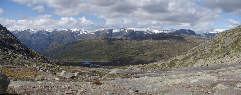
After parkrun, I took a short drive north to park in Gleann Salach, the other side of Loch Etive, where my objectives were a horseshoe of three Grahams around the River Esragan. First up was Beinn Bhreac, a broad and grassy hill with an ATV track leading about half way, then rough and rather boggy grass. It had been dry so far, but I could see some dark clouds approaching as I continued to the 726m Graham summit, Mam Hael.
Looking towards Beinn Mheadhonach from part-way up Beinn Bhreac
Appropriately, a heavy hail storm began as I left the top, and I descended rapidly towards the saddle with Beinn Molurgainn as I could hear some thunder around. Thankfully, the thunder soon stopped and I could see brighter weather approaching, so I decided it was safe to continue back up. The hail had made the ground pretty white, but did turn to rain for a few minutes before petering out. Soon I was on the Graham summit and continuing southeast towards the minor top of Meall Dearg. The various cairns along its ridge proved to be excellent viewpoints over Loch Etive towards the higher, snowy peaks of Ben Starav and Ben Cruachan, and there were a few sunny spells.
Creach Bheinn (Corbett) from a hail-covered Beinn MolurgainnSunshine after the storm, looking towards MullBen CruachanLoch Etive and Ben Starav
Once I’d reached Bealach Carra, it was an easy scramble up the spur to the summit of Beinn Mheadhonach, the final Graham of the day. I overtook another walker, whose footprints I had seen in the hail earlier, on the way up, but didn’t pass closely enough to speak as he had chosen a less rocky line further right. The summit gave good views towards the sea and Mull.
I descended west then northwest down rough, grassy slopes to reach the confluence of the Eas a’ Chrinlet and Eas na Gearr, where the former could be crossed on stepping stones beside an ATV ford, and the latter had a very helpful bridge. Beyond the bridge, an obvious ATV track led quite steeply up onto the opposite hillside then traversed southwest back to my start point. The attractive rocky ground of the second and third Grahams had definitely made up for the boggy first hill and unpleasant hailstorm to give a good day overall! Route map: https://www.plotaroute.com/route/2567681
Beinn Eunaich, from Beinn Mheadhonach
I had been told that I would be sharing the dormitory that night, so was surprised when nobody had turned up by the time I went to bed. Sadly, five others did arrive around midnight and disturb my sleep! Nevertheless, I was well rested by morning and decided to head to a couple of Munros, Beinn a’ Chochuill and Beinn Eunaich, which had looked good across Loch Etive the previous day. The forecast was also good, particularly for the morning, with light winds and sunshine.
Once I’d had breakfast and checked out of the hostel, I drove the half hour to Lochawe and parked by the B8077 junction, wrongly assuming that any places further along the lane were already taken. The first few kilometres were on a good hydro track up the valley, with improving views of the Ben Cruachan group to the left.
Looking up to Stob Diamh from the valley
Then it was a steep and unrelenting climb of nearly 500m up the SE ridge of Beinn a’ Chochuill, significantly aided by the expected Munro-baggers’ path. The climb was essentially snow-free, but a decent cornice remained on the north side of the ridge to make the view more dramatic. I enjoyed more stunning views of Ben Cruachan as I walked west to the summit of Beinn a’ Chochuill, as well as appreciating the row of snowy peaks between Ben Starav and Stob Ghabhar to the north.
Beinn Eunaich, from the ridge of Beinn a’ ChochuillBen Cruachan
Turning back to the east, I followed the good ridge path to the second, higher Munro, Beinn Eunaich, pausing for lunch in a sheltered spot a little below the summit. As it was still quite early, I decided to continue northeast along the ridge to Meall Copagach and the Lairig Dhoireann, rather than following the masses (perhaps 15 other people that day) down the south ridge back into the valley. Although there was a lot of very steep snow on the east face of Beinn Eunaich, the descent on the ridge itself was easily negotiated without ice-axe, and the continuation was snow-free and enjoyable.
Ben Cruachan and Beinn a’ Chochuill, from Beinn EunaichLooking north towards Ben Starav and Stob GhabharLooking back to Beinn Eunaich
As I’d suspected, the mapped path down the valley was faint and intermittent, but it was at least well marked with cairns. Once down in Glen Strae, a few kilometres on the track and road brought me back to the car. I drove another half hour to reach Crianlarich SYHA for the night, where I was able to claim a bottom bunk in an otherwise full dorm. Route map: https://www.plotaroute.com/route/2568631
My plan for my final day in Scotland had been to visit some of the Grahams above Luss, but the mountain forecasts agreed that the far south of the National Park would probably have low cloud in the morning. Instead, therefore, I decided to walk directly from the hostel up a couple of Munros, Beinn Tulaichean and Cruach Ardrain.
My ascent route followed forest tracks up Coire Ardrain, escaping the forest by Creag na h-Iolaire and climbing steeply from there to gain the ridge. The views of Ben More to the left and Cruach Ardrain to the right improved as I continued south to the rocky top of Stob Garbh, and the direct route to Cruach Ardrain looked pretty intimidating with a good covering of snow. Luckily I had thought of that and planned instead to contour across the corrie to the bealach with Beinn Tulaichean and climb that hill first, a route that worked well with some large, flat snowfields to cross. I saw one other walker with his dog near the summit, where I paused for a snack.
Allt Coire ArdrainBen More and Stob BinneinStob Garbh and Cruach ArdrainCruach ArdrainBeinn Tulaichean
Turning back north, I followed the ridge up to Cruach Ardrain, finding some deep snow drifts near the top but nothing requiring use of the ice axe. There were good views of An Caisteal and its neighbours to the west, as well as down into Strathfillan. To return to Crianlarich, I descended the easy ridge via Meall Dhamh (where I paused for lunch) and Grey Height, passing two other solo walkers heading up. On reaching the edge of the forest, I headed northeast to pick up the end of a timber extraction track that I could see not far below, rather than going down the very boggy rides described in the guidebook. Route map: https://www.plotaroute.com/route/2570513
The ridge back to Cruach ArdrainLooking towards Beinn a’ Chroin and An Caisteal
I was back at my car and on the road around 1:30pm and embarked on the drive back to Kendal. Despite some slow traffic through the Trossachs and in Cumbria, I arrived with about 20 minutes to spare before dinner with Mum, Dad, Ruth and Josh. I stayed the night at Mum and Dad’s.
The next morning, Ruth, Mum and I went for a stroll up nearby Farleton Fell to get some fresh air before my final couple of hours’ drive home. It must be quite a few years since my previous visit to this limestone-covered hill, and it was good to refresh my acquaintance. Route map: https://www.plotaroute.com/route/2570518
The summit of Farleton FellDescending from Farleton Fell
My full photo album can be viewed here. Overall, a pretty good Easter trip, with three totally dry days in Scotland and the other two only showery. I had ticked off six new Grahams and revisited four Munros. I now look forward to my next Scottish trip, to Glen Shiel in late May with the Gentian Club.
The second Gentian Club trip of the year went to the High House bunkhouse in Seathwaite, right at the head of Borrowdale – a place very familiar to me after eight January visits with CUHWC between 2004 and 2012! Due to the great location and fairly long drive, I decided it was worth taking the Friday off work and getting an extra day in the hills. Claire travelled with me again, meeting at my house at 7pm on Thursday to head up to my sister’s house in Natland for the night.
On Friday, we had arranged to meet Sheena for a walk in the Newlands valley. Arriving at our start point near Little Town at the appointed time of 10am, we were surprised to find her not already there waiting, until I read her text message saying she’d had to return to Ambleside to pick up an item left behind at the hostel and would walk separately. So we got our boots and waterproofs on in the light drizzle and set off up the path beside Rigg Beck.
Ruth had suggested the stream might be tricky to cross after the previous day’s rain, but her concerns proved unfounded as it was easy to locate a spot where we could simply take a large stride across. Then came a steep, grassy ascent onto the ridge and up it to the windy and misty summit. The drizzle was easing though, at least, and we had some excellent views over the Newlands Valley on the way up.
Looking towards Catbells on the ascent of Ard Crags
As we continued towards Knott Rigg, the cloud lifted a little and we were rewarded with views down towards Rannerdale Knotts. Another steep, grassy slope led us down to Newlands Pass, where we paused for lunch in a relatively sheltered spot overlooking the Moss Force waterfall. Then we continued back up onto High Snockrigg – with good views of Crummock Water – and across the boggy shoulder to reach drier ground on Robinson (back in the mist).
Looking over Rannerdale Knotts to Crummock Water
We continued along Littledale Edge and back up to the summit of Hindscarth, then began our descent north, soon dropping back out of the cloud and gaining views down the valley. The small rocky steps on Scope End added some interest to the route, before the final section across fields to Gillbrow and back along the lane to the car. Route map: https://www.plotaroute.com/route/2553331
Claire on Scope End
Although the drizzle had returned intermittently, we were pleased to finish the day with our waterproofs only a little damp. I opted to take the scenic route to Seathwaite, over the Newlands and Honister passes, and we arrived shortly after opening time at 4pm. Most of the others were also there promptly and after a cup of tea and a hot shower, we soon settled down to the typical Gentian evening of conversation, dinner and drinks. I had accepted Vivienne’s offer of veggie chilli, and very tasty it was too!
Saturday looked much the best day of the weekend, especially in the morning, so we moved breakfast half an hour earlier than normal in order to get out promptly. I offered to lead a long-ish horseshoe walk from Stonethwaite around the Langstrath skyline, which would take in several hills I hadn’t been to for many years! Mike, Claire, and new member Eric opted to join me, while other groups headed to Scafell Pike and High Spy.
We parked just before the village and, after a short walk up the valley, struck off to the right to ascend beside Big Stanger Gill. I had spotted that the route was well-used on Strava, despite not being marked on the OS map at all, but was not expecting it to be an old and well-built stone-pitched path! The steep, wooded and mossy slopes were very attractive to pass through, and offered excellent views back down Borrowdale.
Looking down Borrowdale from the steep path beside Big Stanger Gill
Soon we were on the plateau of Rosthwaite Fell and managed to find our way through the mist to the top considered by Wainwright to be the summit, Bessyboot. There were glimpses of blue sky above so we remained hopeful that the mist would eventually lift off the hills as forecast. That didn’t happen during our traverse up the ridge to Glaramara though! We skirted around Rosthwaite Cam then west below Combe Door to reach the main path, and a short, straightforward scramble then led us up to the summit tors.
Almost sunny at Tarn at Leaves
The cloud did begin to break as we continued south towards Allen Crags, revealing intermittent views of the distinctive outline of Great Gable. By the time we reached the summit of Allen Crags, pretty much all the hills had cleared, except for Scafell Pike.
Brighter conditions looking towards Great GableBow Fell and Esk Pike
We continued up to Esk Hause, which gave excellent views down Eskdale. Mike opted to take the main path to Angle Tarn while Claire, Eric and I went via the summit of Esk Pike – another fine viewpoint over Bow Fell and Langdale, as well as down Langstrath. We met back up with Mike at the outflow of the tarn and paused near there for lunch.
The Scafell range, from Esk PikeThe Langdale PikesMike, Eric and Claire by Angle Tarn
Our next objective was Rossett Pike, quite a quiet hill despite being just off the main path up from Langdale. Bang on schedule, a few spots of light rain began to fall as we continued northeast down to Stake Pass, and you could see that the cloud was starting to drop onto the higher hills. We therefore opted to traverse across the grassy slopes of High Raise rather than going via its summit. Although it was a little rough and boggy in places, I am sure it was the quicker route route to Sergeant’s Crag, as well as keeping us below the cloud to enjoy the views over Langstrath.
Langdale, from Rossett PikeLooking back up Langstrath from Sergeant’s Crag
From Sergeant’s Crag, it was only a very short distance down the ridge to our final Wainwright of the day, Eagle Crag, a fine vantage point over Borrowdale. We followed the obvious trodden path north and down some increasingly-awkward and exposed rock steps through a cliff band, almost deciding at one point to head back up and find an easier way down. [Checking the Wainwright guide later on revealed that there’s a better way, looping around the crags further west!]. We got down unscathed though, and the rest of the descent to Greenup Gill was steep but straightforward. That just left a short walk back down the valley to Stonethwaite. Route map: https://www.plotaroute.com/route/2553334
Borrowdale, from Eagle Crag
Back at the bunkhouse, we hung up our damp waterproofs in the drying room and enjoyed a few cups of tea and a hot shower before dinner. Mike provided a deliciously rich venison casserole for the meat-eaters. Drinks and conversation around the fire continued until bed (but disappointingly the old pot-bellied coal burner has been replaced with a more standard – probably safer – multi-fuel stove that pumps out a lot less heat!).
Sunday started damp, but by the time we’d finished washing up after breakfast it looked like it was brightening up. I offered to lead a walk from the bunkhouse up to Base Brown, then around the Gillercomb skyline to Great Knotts, then down to Honister Pass and back along the valley. Vivienne, Sheena, Eric and Claire decided to join me this time.
High House
Conditions were fairly pleasant as we made the steep ascent up the pitched path – as slippery as it always is – beside Sourmilk Gill. It began to rain as we continued up past the Hanging Stone to Base Brown though, and it was pretty wet walking upwind from there to Green Gable! We were relieved to turn north at that point and have the wind and rain on our backs for the continuation to Brandreth – needing a little compass work to be sure of taking the right line – and Grey Knotts.
Borrowdale, from beside Sourmilk GillHeading up Base Brown
The rain eased again as we dropped down the very wet path/stream to Honister, and we gained some views into Borrowdale. We had a short lunch break as we descended the Coast-to-Coast route, parallel with the road down to Seatoller, but didn’t delay long as it was starting to rain again. The final stretch along the lane to Seathwaite was very wet, and we were happy to get back to the bunkhouse and get changed into dry clothes before the journey home. Route map: https://www.plotaroute.com/route/2553338
Looking towards Rosthwaite Fell
Claire and I were packed up and on the road soon after 2:30pm and had a good drive back down the M6 and A50 to my house, arriving soon after 6pm.
In conclusion, another excellent weekend in the hills, making good use of the days despite mixed weather. Claire bagged 15 new Wainwrights and I enjoyed returning to them too! More photos of the weekend are available here. I look forward to my next trip with the club, to Glen Shiel in May for some big Munro days (hopefully!)
I took a weekend trip to the Lake District to celebrate 35 years of Cambridge University Hillwalking Club, meeting up with around a hundred Old Duffers, current members and dufflings at Derwentwater Independent Hostel. To avoid the Friday evening traffic, but not wanting to miss a Thurday-night band rehearsal, I got an early start on the Friday morning to drive up to Mum and Dad’s house in Kendal and work there “from home” for the day. Then I popped across to Natland for an early dinner and got a lift up to Borrowdale with Ruth and Josh, spending a sociable evening in the hostel catching up with old friends as they gathered.
Saturday started with a full English breakfast prepared by the hostel caterers. After that, I chose to join Michael’s proposed walk from Seathwaite up Great Gable, which attracted a real multi-generational group including both current members and some of the oldest attending Duffers (but no children). Fifteen of us drove up the valley in four cars and parked at the end of the lane. We ascended together on the very greasy path beside Sour Milk Gill, then split into two smaller groups for the ascent of Base Brown. Some (including me) opted for the mild scramble up the north ridge while others took the easier route up the hanging valley and back up from the south. The summit was just about clear, with views down into Borrowdale but the surrounding higher hills not visible.
Looking up Grains GillLooking back down to Seathwaite
The direct route had been quicker, of course, so we actually met the others near the col with Green Gable. To mix up my company for the day, I switched groups and made a second visit to the summit of Base Brown before continuing up the ridge to Green Gable, then back down to Windy Gap – aptly named, as so often. Michael led five others directly down via Aaron Slack while I led two current club members up the steep rocky path to Great Gable, a few minutes behind the six others who had also gone that way.
Damp and misty on Green Gable
It was pretty cold and damp in the cloud at the summit, so we didn’t linger long before checking the compass bearing and starting the descent to Sty Head. We could see the other half-group ahead, and finally caught up with them by the stretcher box. We descended together beside Styhead Gill, getting back to Seathwaite about 15 minutes after Michael’s part of the group, and a little while before a band of heavy rain was forecast to sweep in from the south.
Styhead Tarn
Back at the hostel, we refreshed ourselves with a few cups of tea and hot showers, relaxing and chatting until dinner. The dress code had been advertised as “what you would wear for formal hall”, so I was pleased that lots of other Duffers had made the same decision as me and brought Black Tie anyway, in-keeping with previous Anniversary Dinners. The meal of soup, Cumberland sausage and crumble was simple but hearty, well accompanied by wine and a fun CUHWC-related quiz to tackle in our table-groups. Conversations continued long into the night and I eventually went to bed at around 2am.
On Sunday, I joined Ruth’s proposed walk around the Coledale horseshoe, along with Josh, Phil and John. We parked in Braithwaite and walked anticlockwise, starting with the long ascent to Grisedale Pike. The summit was just in the cloud, but we enjoyed views most of the way up, with the occasional sunny spell.
Looking over Coledale to Outerside, from Kinn
We continued along the easy ridge to Hopegill Head, then dropped down to Coledale Hause. From there, we reascended by the direct route – new to me – to Crag Hill and then around to Sail, pausing for lunch in a sheltered spot on the descent of the ugly zigzag path down its east ridge.
Phil, John, Josh and Ruth on the ridge to Hopegill HeadDescending from Sail
We then opted to take the direct path to Outerside, rather than going over Scar Crags and Causey Pike, and continued along the ridge from there to Barrow and back down to Braithwaite. A good walk with good company, with views most of the way, and drier weather than the previous day.
Sunshine towards Catbells
I travelled back to Natland with Ruth and Josh, paused for a coffee, then hit the road back to Derby, arriving just before 7pm for a fish and chip supper and an early night.
It was great to catch up with lots of old friends, many of whom I hadn’t seen for a few years, and to see that CUHWC continues to thrive. I look forward to the 40th Anniversary! There are a few more photos here and maps of my walking routes here (Great Gable) and here (Coledale).
As ever, the first Gentian meet of the year was the ‘Welsh Winter’ weekend in Snowdonia. Also in-keeping with tradition, the Welsh winter looked like it would offer mainly extreme winds and heavy rain rather than snow, so as I headed west after work on Friday afternoon with Claire, I was doubtful whether we would manage much quality hillwalking! We arrived at the Rucksack Club’s ‘Beudy Mawr’ hut in Nant Peris soon after 7pm, settled in and cooked a quick dinner before an evening of conversation around the fire as the hut gradually warmed up!
Saturday’s forecast suggested the highest cloud levels and least rain would be found in the far northeast, so I offered to lead a walk from Abergwyngregyn up to Aber Falls and, weather permitting, Moel Wnion. Six others opted to join me, while the remaining four walked from the bunkhouse through the slate quarries to Deiniolen and Llanberis and back up the valley. It did seem brighter near the coast, and it was barely raining as we set off up the popular path to the impressive waterfall. I’m pretty sure I had not actually visited the falls before, and this was a good day to do so, after a wet night.
Heading for Aber FallsThe group below Aber Falls (Petra, Sheena, Mike, Claire, Simon and Jayne)
After a few photographs, we continued west on the North Wales Path, passing the smaller falls, ‘Rhaedr-bach’, then made our way up the valley of Afon Gam – hard work into a strong headwind! Once we were near the bwlch we swung right to have the wind behind us on the final ascent up the grassy dome of Moel Wnion. The summit shelter gave reasonable views up to the snowy tops of Foel Fras, with glimpses of Yr Elen and Carnedd Dafydd further away. It did look decidedly murkier over the Glyders!
Heading up Moel Wnion, with snowy Foel Fras in the background (Jayne, Sheena, Simon, Claire, Mike and Petra)Looking towards Yr Elen and Carnedd Dafydd
We descended the grassy slopes north then west to re-join the North Wales Path, with good views towards Anglesey and even a few patches of blue sky. Then it was just an easy walk back to the village, pausing for a late lunch in the relative shelter of the final zigzags. Route map: https://www.plotaroute.com/route/2495534
A little blue sky over the coast as we descended to Abergwyngregyn
We were back at the hut by mid-afternoon to warm up with a few cups of tea. The other group had had a much wetter day in the Llanberis valley, so I felt it had been worth making the drive. The evening was spent pleasantly over dinner, drinks and conversation.
Sunday looked like it would be even wetter and, problematically, even windier, with 100mph gusts expected on the higher tops. Nobody was inclined to attempt a Snowdonian peak, so we scattered to various lower-lying places: a few to Llangollen for a short walk up Castell Dinas Bran (but I wasn’t that tempted having been there in similar circumstances last year), a couple to the Anglesey coast, and Claire and I to the Clwydian Range.
It was a bit brighter further east but still very windy. My chosen route went up the sheltered side of the hills, fairly directly from Cilcain up to the summit of Moel Famau with its distinctive Jubilee Tower. The wind was pretty ferocious at the summit!
Claire at the summit of Moel Famau
We sheltered in an alcove of the tower to put on gloves and waterproof trousers, then set off north along the ridge. The gusts made for tortuous and unsteady walking but did ease a little as we dropped down and crossed Moel Dywyll. Then it was just a short walk back down to the village via the small reservoir at Garth. The rain had stopped again, so we had lunch outdoors in the churchyard before setting off back to Derby. Route map: https://www.plotaroute.com/route/2495536
Claire by the reservoir above Cilcain
Overall, a disappointing weekend of weather, the winds not permitting any high peaks to be climbed, but it was still good to catch up with the other Gentians over walks and in the hut. There are a few more photos here. Looking forward to the next meet, to Borrowdale in March.
On the mid-January weekend previously occupied by the Butlins Contest in Skegness, I organised Rolls-Royce Derby Band’s second annual “(not)Butlins” social weekend. This year we headed to the Peak District, hiring the YHA hostel at Eyam for our exclusive use.
Heather met me at the bandroom after work on Friday and we travelled up together from there in my car, arriving a little before 4:30pm to find a few other early birds already unpacking provisions in the kitchen. We soon settled into our rooms, then the evening passed quickly, chatting over dinner (baked potatoes and toppings prepared by Helen), a few drinks and games.
On Saturday morning, the majority of us headed to Hassop Station to take part in Monsal Trail parkrun, my second visit to this event. A cold but calm and bright morning made for ideal running conditions, and quite a few of the group ran times close to their best. I was happy to knock 30 seconds off my previous time for the course.
Early morning at YHA EyamRRDBRC parkrunners
After returning to the hostel for showers, and bacon sandwiches for brunch, we divided into two groups for the afternoon. Ashleigh led a shorter walk down to Stoney Middleton and Eyam village with a couple of pub stops, while I led a slightly longer one up over Eyam Moor to Bretton Clough, returning via a drinks stop at the Barrel Inn (Derbyshire’s highest pub), We enjoyed extensive views of the eastern Edges and Kinder Scout from the hill summit, and the attractive woodland and steep-sided grassy knolls in the clough. Route map: https://www.plotaroute.com/route/2488889
Looking towards Kinder Scout, from Sir William HillBretton CloughAbney CloughThe group in Bretton CloughPub stop at the Barrel Inn
Helen led the preparation of delicious pulled pork rolls and macaroni cheese for dinner, followed again by chat, banter, drinks and games until late.
We had a more leisurely start on Sunday, with French toast for breakfast followed by packing up all our stuff, cleaning and tidying to check out of the hostel at 10am. Some headed home to relieve relatives on childcare duties, others went for another potter around Eyam village, and I led a group of six on a fairly gentle 15km walk from Grindleford.
The morning was another beautiful sunny one with excellent air clarity. Padley Gorge looked pretty as we ascended in the dappled sunshine before heading towards Longshaw Lodge.
Ascending Padley Gorge
There we turned south, passing the Grouse Inn then following Froggatt Edge (with a lunch break on a rocky outcrop) and Curbar Edge as far as Curbar Gap.
Froggatt EdgeCurbar EdgeCurbar Edge
We dropped down a bit then followed footpaths traversing the lower, wooded slopes to Froggatt village, where we picked up the Derwent Valley Heritage Way back to Grindleford. We had second lunch in the Station Café, then set off home. Route map: https://www.plotaroute.com/route/2488897
Returning to Grindleford along Spooner Lane
A great weekend with the brass band to start the year, hopefully kindling some good team spirit as we head towards the Midlands Regional Championships at the start of March. There are more photos on Google Photos here. Here’s to another great year of banding!
As ever, returning from the Highlands left me underwhelmed by the prospect of a walk in the flatlands of the Peak District. The forecast was reasonable though, so I dragged myself out to the western moors around the Cat and Fiddle Pass to stretch the legs.
I started off south along Whetstone Ridge, then dropped down by Cumberland Brook to Wildboarclough, enjoying the white frost on the rocks and dry-stone walls.
Then it was a steep climb back up to Shutlingsloe, rewarded by extensive, very clear views towards The Roaches to the south, and Macclesfield Forest and Shining Tor to the north, with the Manchester skyline visible in the distance.
Looking towards The Roaches
I continued through the top of the forest then along some quiet footpaths to reach Lamaload Reservoir, which I circuited on the west and north before climbing back up via Andrew’s Edge (pausing for a late lunch in a sheltered spot) to Shining Tor.
Lamaload ReservoirShining Tor, from Andrew’s EdgeShutlingsloe, from Shining Tor
My motivation had increased by that point, so I opted for the longer option of descending to Errwood Hall before climbing back up to the Cat and Fiddle, rather than taking the direct path along the ridge.
Foxlow Edge, from Stakeside
A decent day out overall, with great air clarity. A map of my route can be seen here, and more photos here.
For this year’s New Year break in the Highlands, Ruth, Josh and I rented a cottage in the village of Strontian, which would give a wide range of walking options across Sunart, Ardgour, Morvern and Kingairloch. After breakfast at Mum and Dad’s on Wednesday morning, I said my goodbyes then took the short drive from Kendal to Natland to meet Ruth and Josh at 8am to load Josh’s van and set off on our much longer drive!
For the most part, the journey went well. The only significant delay was a big queue through Dumbarton where the A82 was flooded and all the traffic was being diverted through town. We wanted to go through town anyway to do our main supermarket shop at Morrison’s, but could have done without the traffic jam! It rained pretty much the entire way, so there were a lot of puddles on the road, particularly alongside Loch Lomond, but the morning snow had melted off the road by the time we came to crossing the high ground of Rannoch Moor. After a short wait and smooth crossing at the Corran Ferry, it was just a few miles to our destination, an old croft house with thick, rustic stone walls on the outside but modern décor inside and under-floor heating throughout.
On the Corran Ferry at dusk
Thursday was forecast to be another day of frequent showers merging into continuous rain, so we didn’t think it would be much fun to climb a large hill. After breakfast looked like the least wet spell, and we used it for a 10k trail run from the cottage. We passed through Strontian village then climbed a little to follow the traversing ‘Fairies Road’ up the valley. Then we dropped down to the Strontian River and followed a loop through the attractive deciduous Ariundle Woodlands before returning down the lane. A little light rain fell at times but not enough to be unpleasant and it was good to get out for some fresh air before the heavier afternoon rain. Route map: https://www.plotaroute.com/route/2473008
Ruth and Josh on the Fairies RoadStrontian River
It looked like there should be some good sunny spells on Friday so we opted for a walk up one of the Ardgour Corbetts, Carn na Nathrach. This was a route that would not require fording any significant rivers after the previous two very wet days! A short drive north over the pass brought us to Kinlochan where we found a parking area a short distance up the track towards Glenhurich. We enjoyed some good sunrise colours in the sky as we set off up the forest tracks up the glen.
Beyond the cottage at Glenhurich, we ascended more steeply on zigzagging forest tracks to reach the crest of the ridge, where a small walkers’ path marked by a pair of cairns led a couple of hundred metres through the trees to the edge of the forest. The ridge of Beinn Mheadhoin then offered an easy-angled ascent all the way to the Corbett summit, with some crunchy snow above about 550m. There were particularly good views of the parallel Meall Mor ridge to the north, with the Glenfinnan Munros and Streap becoming visible over the top as we got higher up.
On the Beinn Mheadhoin ridge, with views to Beinn ResipolLooking over Meall Mor towards the Glenfinnan hills
Nearer the summit, we gained views of the pointy peak of Sgurr Dhomhnuill to the south, looking much snowier than our hill. We returned the same way, with Beinn Resipol visible down the valley. Route map: https://www.plotaroute.com/route/2474652
The final approach to Carn na NathrachSgurr Dhomhnuill
On Saturday, a storm was expected to arrive by late morning, so we got up early and were parked up by Loch Sunart at Laudale, ready to start at first light. Ruth and Josh opted to do a bike ride along the lochside track to Glencripesdale and back, while I walked up the nearby Marilyn, Beinn nam Beathrach. My route followed the track past Laudale House, then turned up Glen Laudale for a bit, before forking left onto a rougher ATV track (but still improved with proper drainage) that took me a bit further than mapped, up to around 400m.
Beinn Resipol, from the ATV track
From there, I could see the trig point at the summit, so just made a bee-line directly for it, traversing the northern slopes of Beinn Bhan then ascending fairly steeply on short grass between small crags to the summit. I could see that the rain front was only a few miles away to the south, and it was already pretty blustery. I quickly grabbed a few photos of the view, most impressively over the sea to Rum and Skye, and over Loch Sunart to Beinn Resipol, then started my descent by the same route.
Looking towards Rum and Skye
It didn’t take long to get back to the head of the track, by which time it was snowing lightly. The cloud was dropping fast, so it was good to have the clear path to follow, to save having to think much about navigation. Once down in the valley, the snow had turned to wet sleet, so I put on my full waterproofs for the final few kilometres along the tracks back to the van. On the shore of Loch Sunart, the easterly wind was very strong, and it was a real battle to maintain progress upwind! I was thankful that Ruth and Josh, having got back about half an hour sooner, had moved the van a little closer to Laudale House, beyond the end of the public road, to save me some time in the rain! We returned to the cottage for lunch and a leisurely afternoon indoors. Route map: https://www.plotaroute.com/route/2474650
New Year’s Eve was another day with showers forecast. Ruth was keen to do a hill with coastal views and I fancied bagging a Graham, so we met both objectives by heading to Kingairloch for a walk around the horseshoe of Beinn Mheadhoin. Josh was also inspired by the opportunity to pass above the huge Glensanda granite ‘superquarry’ on the south side of the hill.
We parked by the Boathouse Restaurant, as suggested by the Graham guidebook, and set off through the Kingairloch estate with its main lodge and various associated cottages. We followed a track up to a transmitter on the lower slopes of Sgurr Shalachain, then continued on rough grass, gently then more steeply, to reach that summit, with good views east over Loch Linnhe.
Looking up to Beinn Mheadhoin from KingairlochLooking over Loch Linnhe from Sgurr Shalachain
That was the majority of the hard work done for the day, as the continuation over Beinn na Greine to Beinn Mheadhoin was gentle and grassy, and did not have any significant snow cover. There were distant views of Moidart and Ardgour under cloudy skies to the north, whereas it was a lot sunnier around Glen Nevis and Glen Coe to the northeast. It looked like a day in the Mamores would have been a great choice for those based the other side of the ferry! To the south, Mull was mostly obscured by low cloud, but there were good views over the sea towards Oban, with the peaks of Scarba and Jura visible in the distance.
Beinn Mheadhoin from Beinn na GreineJosh and Ruth on Beinn Mheadhoin
We continued around the horseshoe to Beul Choire nan Each, there gaining our first view of the quarry. Further along, a viewpoint had a sign pointing out the key features, including the “glory hole” shaft used to deliver the crushed granite 500m vertically downwards for extraction to the coast.
Looking over the Glensanda Quarry to the seaSunnier conditions over Ben Nevis, the Mamores and Beinn a’ Bheithir
We found a sheltered spot for lunch, then descended easily by the ridge of Meall an Doire Dhuibh. A zigzagging stalkers path led down the final stretch to the cottage at South Corry, where we picked up tracks back to the van. We were pleased to have got away without any significant rain all day. Route map; https://www.plotaroute.com/route/2476267
Josh and Ruth on the descent ridge
New Year’s Day promised high cloud and we were keen to find some deeper snow so we headed to the highest hill in the area, Sgurr Dhomhnuill. The skies were quite clear as we set off from Ariundle after a very short drive up the valley, and the peak was visible in the distance. The first few miles were up good tracks through the Ariundle woodlands – with lots of attractive moss and ferns on the trees – to the old lead mines at Fee Donald, one of the places where the element strontium was discovered in the ore and named after the village.
Moss and ferns
We crossed the fairly large stream without much difficulty and were soon on the snowy slopes of Druim Leac a’ Sgiathain, mostly following footprints left by others who had been up on previous days. A heavy shower missed us to the south, followed by dramatic light conditions towards Garbh Bheinn, with shafts of sunshine through the broken cloud swirling around its summit.
Looking towards Sgurr a’ Chaorainn and Sgurr nan CnamhDramatic light over Garbh Bheinn
Higher up, we opted to take the ridge route over the subsidiary summit of Sgurr na h-Ighinn, leaving behind the footprints that had taken the traverse route to the left. The snow was steep enough to get the ice axe out for security, but not hard enough to want crampons.
Moody skies over Sgurr DhomhnuillSgurr a’ Chaorainn and Garbh Bheinn
We dropped down to the saddle then ascended more steeply up the final cone of Sgurr Dhomhnuill. Here, the recent snow had almost eradicated traces of the previous visitors’ route, but the obvious ramps and ledges led us to the summit without difficulty. The next shower passed us by to the north! We took in the magnificent views for a while on the calm summit, then headed back down to the saddle, following our own footprints. This time we took the traverse path around the side of Sgurr na h-Ighinn, pausing for lunch part way along. It stayed dry for the descent to the mines, then a bit of light rain set in for the final few kilometres through the forest. A great winter’s day on the hill! Route map: https://www.plotaroute.com/route/2476269
Sgurr DhomhnuillThe view from Sgurr Dhomhnuill towards Garbh Bheinn
For our final day, we headed west along the Ardnamurchan peninsula. I was dropped in the hamlet of Laga for another Marilyn-bagging walk, while Ruth and Josh drove out to the lighthouse and nearby beaches for a coastal stroll. Ben Laga proved to be an attractive, rocky summit, despite its modest height of just 512m. I ascended on a good track through the 10-year-old Laga Woodlands, then fairly direcly up heather and grass between the crags to the summit, with its two cairns and a small lochan. It was just below the cloud, so I was able to enjoy the views along Loch Sunart towards Ben Hiant, and also towards Beinn Resipol and Loch Shiel.
Loch Sunart and Ben Hiant, from Ben LagaMany lochans north of Ben Laga
I followed the ridge north and then dropped down to the end of Loch Laga, before re-ascending on easy grassy slopes to a slightly lower Marilyn, Meall nan Each (490m). This was not as interesting a peak but gave good views towards Moidart. I had lunch in the shelter of a crag, then descended south to pick up the tracks back to the road. As Ruth and Josh had said they would be about another hour, I chose to walk a couple of kilometres east to the next car park at Port nan Gall, to fill the time. It had been another day with fewer showers than forecast, and I was surprised not to have needed my waterproofs! Route map: https://www.plotaroute.com/route/2477128
Loch Laga and Ben LagaColourful forest near Port nan Gall
We got all the packing done that we could on Tuesday evening, and were able to get away by 8am on Wednesday morning. After crossing the Corran Ferry, we paused for half an hour at the younger Duffers’ cottage in Ballachulish, then continued on our way south. The drive went well, arriving in Natland around 2:30pm. I continued straight away and was home just after 5pm, in time to do most of my unpacking and get some laundry on before heading out for my usual Wednesday evening run with friends in Hartshorne!
In summary, a good varied week in the Highlands. The weather was generally better than forecast, and the waterproofs didn’t get used very extensively at all! I ticked off one new Graham and three other new Marilyns, and revisited two Corbetts, and the day on Sgurr Dhomhnuill felt like a proper winter outing. My full photo album can be viewed on Google Photos here.
After a year’s break while they were in rented accommodation, my parents returned to hosting our Christmas family gathering, at their new house in Kendal. I took the Friday off work and travelled north in the morning, thus avoiding the evening rush. In the afternoon, I made a start on pressure washing the patio and paths around the perimeter of house.
Saturday was a fairly wet day, but started with a dry weather window for a visit to Penrith parkrun. Dad participated in the run and Mum came along to spectate. A strong westerly wind made parts of the course hard work, but gave me a good excuse for being 40 seconds slower than on my previous visit in the summer. After I’d scanned my barcodes, I caught up with Dad for the remainder of his second lap. We stayed at home in the afternoon, and Mum and I enjoyed a game of Scrabble.
Dad and me, post-parkrun
Christmas Eve was a little brighter. I finished off the pressure washing in the morning, then Ruth and Josh joined us for a pre-lunch walk from Sizergh Castle up the ridge to Helsington church and back. We enjoyed good views over the Lyth Valley and Morecambe Bay.
On the track near Helsington church
On Christmas morning, Ruth and Josh took the opportunity to join me for a bonus parkrun. This year we chose Lancaster, where we knew there would be a chance to see Joe and Andrena, and Josh’s brother Toby. The course was exactly as tough as I remembered it from my one previous visit in 2017, with two steep climbs on each lap, and a very muddy section beside the small reservoir. I couldn’t keep up with Ruth’s fell-running colleague, Richard Mellon, but was pleased to be within 10 seconds and to finish in under 21 minutes.
Once back in Kendal, and showered and changed, we sat down by the Christmas tree to open the presents. Then we enjoyed our traditional roast turkey dinner before a lazy afternoon. I helped Dad set up his new tablet while Ruth, Mum and Josh played a couple of games.
Boxing Day looked like the one nice day of the visit, so we took a morning trip to Tarn Hows for a family walk, arriving fairly early in anticipation that the car park would get busy later on. There were beautiful reflections as we set off around the west side of the tarn.
Reflections in Tarn HowsPoorly-camouflaged Belted Galloways!
Then we picked up some tracks through the forest to reach the slopes of Black Fell, and followed the grassy path up to its summit for views over Coniston Water. We could see that an unexpected rain shower was approaching over Wetherlam, so we didn’t hang about long before setting off back down to Tarn Hows, completing our circumnavigation by following the paths on the east side back to the car.
On the track below Iron KeldDad, Mum, Ruth and Josh at the summit of Black Fell, with views of Coniston Water
The final Gentian weekend trip of the year was to Wharfedale, staying at the cosy Skirfare Barn near Kilnsey Crag. As I often do, I decided to head up a day early and get an extra day’s walking, so I drove up to my parents’ house in Kendal on Thursday evening. After breakfast together on Friday, it was only a 45 minute drive via Sedbergh to the village of Hardraw, at the head of Wensleydale. It had been a cold night, but luckily all the roads had been well gritted.
My motivation for choosing this location for my walk was that an obscure nearby summit, Sails, has recently(ish) superseded adjacent Little Fell as a Nuttall, having been found to be marginally higher. Not having passed over Sails on my previous visit to Little Fell, I needed to return to re-complete the list. I think this was the fourth time I’ve had to re-complete the Nuttalls since my original completion on Mynydd Mawr!
My route was a clockwise circuit of Cotterdale, mostly under a very thin layer of snow. The initial climb up to Cotter End gave excellent sunny views over Wensleydale. Then came a more gradual ascent of the ridge, mostly on ATV tracks but rough and pathless in places, eventually reaching Sails with its small cairn. There were great views towards Wild Boar Fell, to the west.
Widdale Fell, from below Cotter EndSwarth Fell and Wild Boar Fell, from Sails
I continued over Little Fell, then down and back up to the next Nuttall up the ridge, Hugh Seat, which has a more substantial cairn. Surprisingly, I was following a set of fresh footprints for this section of the walk! Then I turned back to the southeast to cross rougher ground, with no footprints, to the day’s high-point, Great Shunner Fell. I chatted with two men at the summit shelter as we ate our lunches and waited patiently for the mist to break up to reveal the views properly – which it duly did. Ingleborough, Whernside and Gragareth were prominent to the south, with Wild Boar Fell still dominating the view to the west.
Looking towards Ingleborough and Whernside, from Hugh SeatThe summit of Great Shunner Fell
The final few miles back to Hardraw were quick and easy, gently downhill on the well-surfaced Pennine Way, with great views across Wensleydale. Route map: https://www.plotaroute.com/route/2455505
An icy sink hole and tarnHeading down in to Wensleydale
Then I had a 40 minute drive over the Bardale Head road – 589m above sea level but also gritted and free of ice – to reach Langstrothdale and Wharfedale, arriving at the bunkhouse at around 3:50pm – perfect timing as that was just 10 minutes before we could check in! The evening was spent over dinner, wine and discussion as usual. I had accepted Debbie’s offer to share her tasty vegetarian Moroccan dish.
It was a very cold start on Saturday morning, the car thermometer reading -8 degrees as Sheena and I drove up to Kettlewell to start our walk. Our first objective was Great Whernside. We ascended along Dowber Gill and looked down the entrance to Providence Pot, then zigzagged back up to the left to reach Hag Dyke, a scout centre. It was good to escape the shade of the valley and feel the warmth of the sunshine on the open slopes above!
Looking down Dowber Gill into sunny Wharfedale
Another kilometre of steady climbing brought us to the summit, with its attractive rocky outcrops and trig point, looking particularly good in the snow. Pen-y-ghent and Ingleborough were visible to the west, and Pendle Hill in the distance to the southwest.
Looking towards Pendle Hill (right of centre)Sheena at the summit of Great Whernside, with Buckden Pike in the distance
Northwards lay our route ahead to Buckden Pike. We followed the flat ridge to Nidd Head then descended fairly steeply down to the road at the col, taking care over a few slippery sections. From there, the re-ascent to Buckden Pike was fairly gentle and straightforward, the boggy sections being easy thanks to being well frozen. We paused briefly to look at the Polish War Memorial, commemorating the death of five airmen, before continuing to the summit trig point and cairn.
On the ridge of Great WhernsideFountains Fell, Pen-y-ghent and Ingleborough, from the summit of Buckden Pike
Although we were ready for lunch, we decided it was too cold in the breeze near the top, and instead dropped down a bit on the permissive path into the head of Buckden Beck, where we found somewhere warmer and more sheltered. Then we had a quick look at the remains of Buckden Lead Mine before picking up the easy-angled footpath descending south to Starbotton. That just left a few kilometres along the valley to Kettlewell and the car. Route map: https://www.plotaroute.com/route/2456211
Looking into LangstrothdaleApproaching Starbotton
For the evening meal, we enjoyed hearty servings of red pepper soup, followed by Julia’s excellent pork and cider casserole (for the meat-eaters), and Mike’s delicious apple strudel for dessert. After a good walk and large meal, by 10:30pm most of us were ready to turn in for bed.
A little bit of fresh snow fell overnight, so I was glad that I had decided to leave the car in a nearby layby rather than in the bunkhouse car park at the bottom of a steep slope. We had breakfast, packed up our stuff and cleaned/tidied the barn, then set off on our respective outings. Ted led a few up Buckden Pike (which I didn’t fancy having been there the previous day) while Debbie led a tea-shop walk from Grassington (too low and short to interest me!), so I went for a solo walk from Arncliffe onto the limestone plateau to the south.
Again, the road had been well gritted and was straightforward to drive. Sadly the cloud was very low, so it only took a few minutes walking up the “Monk’s Road” path before I lost any views. I continued south as far as Middle House, where the cloud did lift a bit to reveal some attractive knolls and limestone crags.
Limestone crags on ‘Height’
I looped south to pick up the bridleway along the upper section of Gordale Beck and climb back up towards Lee Gate High Mark. From that saddle, I made two bagging detours, firstly west to Parson’s Pulpit (HuMP and Dewey), and secondly east to Proctor High Mark (another Dewey). Neither gave views, thanks to the thick mist, but it gave me some clear objectives for the day.
Lee Gate High Mark
Back at the saddle, I ate my lunch before following the bridleway north, gently down to Arncliffe Cote. I took a short detour to get a closer look at some very impressive icicles where Cote Gill tumbles down a small crag. Once back in the valley, it was just a couple of kilometres along the riverside back to Arncliffe village. Route map: https://www.plotaroute.com/route/2456784
Icicles on Cote GillThe River Skirfare, near Arncliffe
Although unpleasantly sleety much of the way and fairly busy with traffic, my drive home went pretty well, taking a little over 2h30 via Bradford, to arrive soon after 5pm. Although I had walked solo two days and only with Sheena the other, it was good to catch up with everyone at the bunkhouse and enjoy the communal meals together as usual. Three good dry days on the hill, giving a great first taste of winter for this year! I look forward to the Welsh Winter meet in January.
Amazingly, over a month had passed since my last walking day, if I don’t count a couple of Peak Raid races! Finally I had an empty day in my diary and a dry – if rather grey – forecast. After suffering from a heavy cold for much of this week, and with a chesty cough still lingering, I went for something not too strenuous, starting from the village of Ilam. Having attended the Gentian Club Annual Dinner recently in Fenny Bentley, but not having been available to join in with the associated trip to Ilam Hall bunkhouse, I also felt somewhat inspired to follow in their footprints!
I fancied walking down Dove Dale rather than up it, for a change, so set off north from Ilam, crossing a frosty Ilam Park then passing Castern Hall to follow a scenic footpath along the eastern rim of the Manifold valley towards Wetton village.
Looking down the Manifold valley towards Musden LowSoles Hill
I then visited the two tops of nearby Wetton Hill, and enjoyed the views back down the Manifold and north over Ecton Hill, before descending southeast to Alstonefield and then down to Milldale.
Ecton Hill, from Wetton Hill (west top)Looking southeast from Wetton Hill (east top)
I continued down the main Dove Dale footpath, pausing to appreciate the caves at Dove Holes, then the pinnacle of Ilam Rock. The path was damaged in places following the recent flooding, but not at all difficult to pass. Further down, I took the opportunity to head up the short side-path through the impressive natural limestone arch that leads to Reynard’s Cave. Surprisingly, I don’t think I’ve ever actually made that short detour before!
Dove HolesAscending through the natural archLooking back down from Reynard’s Cave
After a lunch break at Lover’s Leap, I was just left with a short walk down to the car park then over the fields – the muddiest path of the day – back to Ilam. I gave my boots a bit of a wash in the river before driving home!
A map of my route can be seen here, and more photos here.
Mid-October brought my usual autumn week in the Highlands. This year I decided to make the driving easy by spreading the northward and southward trips over three days each. My travels commenced on the Thursday night, heading up as far as my parents’ new house in Kendal. Friday morning was a bit damp, so we had a leisurely start and an early lunch before heading out for an early-afternoon stroll on nearby Scout Scar. We were lucky to have sunshine, giving great views towards the Lake District and Morecambe Bay.
Mum and Dad on Scout Scar
After that, I continued my drive, heading up to Pitlochry Backpackers’ Hostel for the night, with a quick dinner stop at McDonalds at Stirling Services. Parking was tricky, with the town thronging with evening visitors to the ‘Enchanted Forest’ and extra restrictions on the streetside bays, but I found a space to squeeze into in the hostel car park after taking a second look on foot,
I began Saturday with a visit to Faskally Forest parkrun, just north of town. It was a beautiful sunny morning, with the early-autumn forest colours shown off to good effect across the loch. The course is a challenging one, with seven sharp ascents totalling around 100m, and some rough terrain underfoot, so I was pretty happy to finish in just under 21 minutes.
Loch Faskally
Afterwards, I drove half an hour south to the hamlet of Amulree for a walk over a pair of Grahams. The route was essentially a horseshoe of the Girron Burn. I crossed slopes of grass and heather to reach Meall Reamhar – with good views towards Glen Almond and Schiehallion – then made a steep descent and reascent across the bealach to Meall nan Caorach, followed by an easy grassy descent back to Girron. The sunshine continued, but it was pretty cold in the breeze. Route map: https://www.plotaroute.com/route/2419214
Looking into Glen Quaich from Meall Reamhar, with Schiehallion in the distance
Once back at the car, I set off for the final section of my journey north, up to Torridon with a pause to pick up groceries at Tesco Extra in Inverness. This was the first time I’d stayed at the SYHA hostel in Torridon village, and I found it to be excellent – spacious, comfortable and well-equipped. I cooked and ate, then planned my walk for the next day, and had a good night’s sleep.
With fairly strong winds, cloud likely to be around 700m, and a possibility of frequent showers, it seemed like a good day to bag another Graham. My choice was Beinn a’ Mhuinidh, north of Kinlochewe. The guidebooks recommended an interesting route that I wouldn’t have picked out from the map alone, ascending on a small path beside the impressive waterfall on the Allt na Still, which tumbles down the crag on the southwest side of the hill. That gave access to the high western terraces, which were an impressive viewpoint for Slioch, not far away to the west.
The waterfall on Allt na StillSlioch
The summit was just in the cloud, and quite cold in the wind, so I didn’t pause long there before descending south, soon regaining views over the plateau with its many small lochans. With the weather apparently brightening, I opted to make the small detour to the minor top of Meallan Ghobhar, before descending steeply by another small path beside the Allt Chnaimhean. This final section gave particularly good views over Kinlochewe to Beinn Eighe. Route map: https://www.plotaroute.com/route/2419217
Lochans on the lower plateau of Beinn a’ MhuinidhBeinn Eighe
Monday’s forecast was a little better, with the cloud expected to lift off the higher tops in the afternoon, so I opted to walk up the pointy Corbett of Beinn Damh, via the adjacent Graham, Beinn na h-Eaglaise – a clockwise circuit of Coire Roill. The initial climb through the forest above the Torridon Hotel was easy and pleasant, with an impressive waterfall in the gorge below, and gave access to a fairly easy, rocky ascent of the northwest ridge of Beinn na h-Eaglaise. Cloud was swirling around the summit but giving intermittent views up Glen Torridon and along Upper Loch Torridon. Beinn Damh and the Glen Carron Munros were stuck in thick grey cloud though, so I had no views that way!
Allt Coire RoillUpper Loch Torridon
The descent to the bealach at Drochaid Coire Roill was more awkward than expected, with a series of small rocky terraces to find a way through. The climb up the other side onto Beinn Damh was very steep and heathery, but I found that any scrambling was easily avoided, which was welcome in the damp and slippy conditions. The cloud didn’t seem to be showing any sign of thinning or lifting, and the visibility at the summit was very poor, such that I required a compass bearing to follow the ridge path onwards, despite that path being marked with closely-spaced cairns!
It was only when I dropped off the side of the ridge into the head of Toll Ban that I finally got clear of the cloud at around 550m. Torridon village and the loch seemed to have been in the sunshine all day, while all the mountains were in thick, damp clag! The good path made for a quick descent back to the car. Even by sunset, the cloud had not lifted off the hills, so at least I did not wish I had made a later start. Route map: https://www.plotaroute.com/route/2419222
Sunshine over Glen Torridon
Tuesday was the one day with an excellent forecast, so it was no surprise that Amy picked that day to meet for a walk. We decided to take advantage of the fact that we had two cars available and do a linear traverse over both the Applecross Corbetts. We met, around sunrise, at Tornapress at the bottom of the Bealach na Ba road, and drove up to the top of the pass in convoy. There seemed to be a rush of traffic into Applecross at that time of the morning, but luckily almost nobody going the other way (it’s a single-track road). We left my car at the top, then drove back down in Amy’s, and north to the shores of Loch Shieldaig, where we parked at Inverbain.
Early morning sunshine on the Cuillin, from the Bealach na Ba
The stalkers’ path beside the Allt an Srathain was pretty solid and rocky to start with, but became boggy and indistinct as we approached the bealach below Croic-Bheinn. There were excellent views over the loch to the Torridon hills as we climbed. At the bealach, we turned left to cross fairly rough, grassy terrain to reach the long north ridge of Beinn Bhan, which gave improving views towards Skye on the right and the Glen Carron hills on the left.
TorridonLooking over Loch Lundie to the Torridon and Glen Carron hills
Once past the Far North Top (the unnamed 710m ring contour), we stuck close to the eastern side of the ridge to enjoy the dramatic views over a series of steep and rocky corries: Coire Gorm Beag, Coire Gorm Mor, Coire Toll a’ Mheine, Coire an Fhamair, and Coire na Poite – lots of photo stops required!
Coire Toll a’ MheineAmy above Loch Lundie and Loch ShieldaigCoire an Fhamair
Eventually we reached the summit of Beinn Bhan, then turned west for the long and rough descent to Bealach nan Arr. There were fragments of path here and there, but often they were not easy to spot from above! We traversed a terrace around the head of Coire nan Arr then continued south, climbing steadily to the transmitter on the west top of Sgurr a’ Chaorachain.
Amy on Beinn BhanCoire AtadailAmy above Coire nan Arr
After a long and mostly pathless walk, it was good that the continuation to the summit of Sgurr a’ Chaorachain only involved a modest descent and reascent, and had a small path much of the way. The narrow ridge gave more superb views of the Na Ciochan ridge towards Beinn Bhan. After a short pause at the summit, we headed back to the transmitter, then easily down the access track to the Bealach na Ba, arriving a bit before sunset. That just left me to drop Amy back to Inverbain on my way back to Torridon. A fantastic day out on dramatic hills with good company and perfect weather! Route map: https://www.plotaroute.com/route/2420319
Na Ciochan and Beinn BhanReturning from Sgurr a’ Chaorachain, with sunset behind Skye ahead
Wednesday was a windy but mostly dry day, with high cloud. I was sorely tempted to have a go at a traverse of Liathach with an attempt at bagging Meall Dearg, the Munro Top beyond the Northern Pinnacles, but finally decided it was too reckless in the wind. With hindsight, it might actually have been okay. Instead, however, I headed back around past Kinlochewe to bag another Graham, Beinn a’ Chearcaill, which offered fine views of the north side of Beinn Eighe.
My walk started up the good stalkers’ path up Glen Grudie, then forked right onto an unmapped path up Coire Briste, which petered out at a lochan near the bealach on the ridge. As the weather was pretty good, I opted to include the book’s suggested scenic detour to Creag na Feol, which gave grand views into the big corrie between Ruadh-stac Mor and Ruadh-stac Beag.
Beinn Eighe and Liathach, from Creag na Feol
Then it was an easy walk west across the plateau, with a tail wind, to the main summit of Beinn a’ Chearcaill. The summit area is very unusual, a huge flat sandstone slab scattered with boulders, with a cairn at the northwest end. The views into Beinn Eighe’s Coire Mhic Fhearchair, with its famous Triple Buttress, were particularly good. Beinn Dearg (with Beinn Alligin beyond) and Beinn an Eoin were also impressive to the west.
Coire Mhic Fhearchair, Sail Mhor, and Spidean a’ Choire LeithThe summit of Beinn a’ Chearcaill
Once I’d finished taking in the scene, I continued for three kilometres north along the ridge to the minor summit of A’ Choineach Beag, a better viewpoint for Loch Maree, with the Letterewe and Fisherfield hills beyond. I found an almostly totally sheltered spot below a crag to eat my lunch, then pottered back down Coire Briste and Glen Grudie to the car. Route map: https://www.plotaroute.com/route/2421225
Loch Maree
On Thursday, the easterly winds picked up much more, as Storm Babet pushed into Scotland. The forecast predicted 108mph gusts on Liathach, so it was no day to be on the high hills! As it was dry, however, I didn’t want to write off the day entirely, and decided to see if I could get up the lee side of nearby 437m Marilyn, Seana Mheallan, which had looked attractive from Beinn na h-Eaglaise on Monday. Others on the hill-bagging website had recommended a route along the Abhainn Thrail then up one of the streams on the southwest of the hill, and that proved to be good advice. The river had several pretty sections of rapids, then a small path beside a deer fence led me up into the corrie, only leaving a straightforward and mostly sheltered climb on grass to get close to the top.
Abhainn Thrail, and Seana Mheallan
The wind was really whipping across the summit, picking up water from the small lochans to give heavy spray downwind. However, it was only a short, crouched-down dash from the last sheltered spot to the summit cairn, where I was able to brace myself against the rocks to get a few photos before beating a retreat back to the calm! Route map: https://www.plotaroute.com/route/2422049
The summit of Seana Mheallan, with Liathach in the backgroundThe view towards Maol Chea-dearg
I descended the same way, then drove east to Inverness, pausing in a layby for lunch near Achnasheen, and getting really poor fuel economy driving directly into the wind! I was too early to check into the SYHA hostel, so I left the car there and walked into town for a bit of a look around, passing the castle and cathedral and some of the bridges over the River Ness. I went back to the hostel, relaxed for a bit over tea and biscuits, then headed back into town in the evening for a meal out at Pizza Express – tasty!
Inverness Cathedral
Storm Babet continued on Friday, with frequent, heavy showers and more strong winds expected on the Cairngorms and Perthshire hills, so a hill day didn’t really appeal. It was dry in Inverness, so I opted for a rare flat, low-level walk along the River Ness and the Caledonian Canal. Carnarc Point gave a good view of the Kessock Bridge and the Beauly Firth at the start of the walk. Then I followed the canal all the way to Dochgarroch Lock – fairly dull walking with scenery that only changed very slowly! I had lunch there before walking back down the other side of the canal, finally heading back into the city via the attractive Ness Islands. Route map: https://www.plotaroute.com/route/2423672
Kessock BridgeDochgarroch LockNessie!
I spent the rest of the afternoon driving around 3 hours down to Stirling, where I again stayed in the SYHA hostel. I was feeling lazy so got fish and chips for dinner rather than cooking.
On Saturday, I found that I was just far enough west for there not to be flooding, and for the parkruns not to be cancelled! Having done Plean parkrun before, I went to University of Stirling parkrun this time. This was a two lap course, around Loch Airthrey in the middle of the university campus. It was quite drizzly as I warmed up, but pretty dry for the parkrun itself, and I ran a good time of 19:31 on the firm, mildly-undulating paths. There were a lot of other people milling around due to a university open day that morning, so I was impressed they had allowed the parkrun to go ahead!
Airthrey Loch
I spent the rest of the morning driving back down to my parents’ house. I had lunch with them, then we met up with Ruth and Josh for a stroll in nearby Levens Park. We all had dinner together, then my parents and I walked down to town for a choral concert by the Royal Northern Sinfonia and Chorus, the highlight being Mozart’s Requiem. An enjoyable performance, and it was good to see the hall where my parents go for their cultural nights out.
I rose early on Sunday, as I wanted to be in Castleton (in the Hope valley, in the Peak District) by around 8am for the second of this autumn’s Peak Raid events! The drive was predictably quiet. Once parked and registered, it was a 2km walk up the lane to the start location, with some lovely early-morning views of Mam Tor and the valley. The race itself took me over Hollins Cross and across Edale to the southern edge of Kinder Scout, then back across Edale to Rushup Edge and down to Castleton to finish. I slightly misjudged it, finishing 6 minutes late and losing a few of my hard-earned points, but still had a fun (if very tiring!) morning’s running.
Sunshine in the Hope Valley
That brought an end to a varied and relaxing week of walking and running. I hadn’t revisited any Munros this time, but did revisit three Corbetts and tick off five new Grahams, as well as two new parkruns, despite the mostly fairly poor weather. A good break before the final couple of working months of the year.
My full photo album can be found on Google Photos here.
My first Gentian weekend of the autumn took me back to a bunkhouse I had previously stayed in in 2007 and 2012 with CUHWC: the Stafford Mountain Club’s cosy Bryn Hafod hut at the head of Cwm Cywarch, near Dinas Mawddwy. I was looking forward to refreshing my acquaintance with the place, and to seeing the regular club members again, a few months having passed since the last trip.
I took the Friday off work to spend an extra day in the hills. Claire had arranged to get a lift to Wales with me and met me at my house at 9am. The drive west was without significant delay, and we met Sheena in a layby near the bottom of Arenig Fawr soon after 11:30. The weather didn’t look promising so we got our waterproofs jackets on from the start, heading back along the lane for a mile or so, then along the good track to Llyn Arenig Fawr. There we chatted briefly with a couple of men who were whitewashing the inside of the tiny MBA bothy by the dam.
We continued up the well-walked path up the ridge of Y Castell, soon pausing to put on waterproof trousers as the mist was very damp and carried a little light rain with it. Sadly we didn’t get any views higher up the hill. We were surprised to see one other walker going up and two coming down. We paused for a late lunch in a sheltered spot below the ridge, then made our way up over the final craggy section to the trig point and memorial to the American airmen killed in a plane crash on the hill in WW2.
Ascending to Arenig Fawr
The south-westerly wind was pretty severe on the summit ridge, so we abandoned our plan to continue to Moel Llyfnant and instead returned by our more sheltered route of ascent. The cloud had lifted slightly to give somewhat better views over the lake, but there wasn’t much else to note. Anyway, it’s always good to get out on the hill! Route map: https://www.plotaroute.com/route/2412126
Claire and Sheena by Llyn Arenig Fawr
The drive over the steep and narrow Bwlch y Groes road to Cwm Cywarch took around 40 minutes, after which we made two trips on foot from the car, half a mile up the valley to the bunkhouse, to carry all the luggage and provisions in. Ted, Martin and Mick had arrived a short while earlier, and the six of us were the full complement for this trip! Ted cooked an evening meal for us, enjoyed over wine from the Gentian bar as ever.
I was on breakfast duty for the weekend, so rose a few minutes earlier than the others on Saturday morning to prepare the porridge and toast. After that, with the bunkhouse being so well located at the foot of the hills, we all opted to walk directly from there. I led Mick and Claire on a clockwise route over Glasgwm and Aran Fawddwy, while Ted led Martin and Sheena on an anticlockwise one going further north to Aran Benllyn but omitting Glasgwm.
Setting off from Bryn Hafod
We ascended by the good zigzagging track below the dramatic crags of Craig Cywarch to the minor summit of Y Gribin, then continued north up the fence-line to Glasgwm, which has a small tarn near the summit cairn. Although we didn’t have any views up to this point, it was clear that blue skies were not far away, as we had glimpses of them from the top.
Ascending below Craig CywarchCwm CywarchSunshine overhead on Glasgwm
The descent north was quite steep and rocky, which Mick found tricky. By the bottom, he had decided that it would be better if he left Claire and me to walk ahead to Aran Fawddwy while he took the more direct route down over Drysgol. We continued together, enjoying increasing breaks in the cloud, as far as Gwaun Llwyni, where we paused for lunch in the sunshine with a grand view down Cwm Cywarch.
Lunch overlooking Cwm Cywarch
Then Claire and I walked more briskly up the ridge to the rocky summit of Aran Fawddwy, its trig point poised dramatically above the eastern cliffs that plunge down towards the waters of Creiglyn Dyfi. We paused for a while at the summit to take in the excellent views in all directions, particularly towards Cadair Idris and the Rhinogs. The high hills of northern Snowdonia remained in the cloud though.
Creiglyn Dyfi, below the cliffs of Aran FawddwyAran Benllyn, from Aran Fawddwy
We descended by good paths over Drysgol, then over much rougher, boggier ground to the head of Cwm Terwyn to pick up the southern of the two public footpaths shown on the map. Although its line was very clear on an easy-angled, man-made terrace, the going was disappointingly awkward through tussocky grass and reeds, and rather boggy in places, so we were glad to make it down to the easy ground by the farm at Ty’n-y-maes. From there, it was an easy mile or so back up the lane to the bunkhouse.
HengwmCwm Terwyn
By chance, we caught up with Mick right at the bottom of the Hengwm path (by which he had descended) and walked the final few minutes together, arriving around 6pm. We enjoyed tea, cake and hot showers while we waited for the others, who got back an hour later, making full use of the available daylight! Route map: https://www.plotaroute.com/route/2412130
The evening meal consisted of soup provided by Ted, followed by an excellent beef curry prepared by Mick for the meat-eaters, and Sheena’s crumble for dessert. All very tasty and filling! We chatted around the fire until retiring to bed a bit before midnight.
After Sunday breakfast, we all spent some time packing our stuff and tidying up the hut. Claire had expressed interest in a walk up Rhobell Fawr, and I was happy to oblige, it being more than 10 years since my last ascent. The others opted to walk from the hut again, up Glasgwm and Pen y Brynnfforchog, so we said our farewells before setting off for the 20 minute drive to the village of Rhydymain.
This time it was sunny from the start of the day. We ascended on good tracks up the southern flank of the hill to about 450m, before striking off up the steep, grassy and rocky slopes for the final 300m climb to the summit. This side of the hill is more impressive than the north side from which I approached previously!
A mossy wall above RhydymainClaire, and the southern crags of Rhobell Fawr
As we climbed, Aran Fawddwy dominated the view to the east, while the ridge of Cadair Idris looked impressive to the west. Then from the summit, most of the other hills of Snowdonia came into view. We admired the distinctive outline of the Rhinogs, and could clearly see Moel Hebog, the Nantlle Ridge, Snowdon, the Glyders and the southern Carneddau in the distance to the northwest. Arenig Fawr, which we had climbed on Friday, was not far away to the north too.
The view towards Cadair IdrisLooking north to Moel Hebog, the Nantlle Ridge, Snowdon, the Glyders and the CarneddauThe Rhinogs
We descended a short distance to find shelter for lunch, then continued down a grassy path to the edge of the forest to the east. We followed the signposted, but very boggy, rides through the forest to reach the open ground the other side for a very rough ascent over tussocky grass and heather to Dduallt.
Looking back to Rhobell Fawr, with Cadair Idris beyond
After taking in the views there for a few minutes, we weren’t very keen to return to the saddle the same way, so gambled on a descent along the fence-line northwest. This turned out to be much easier underfoot, with another (less wet) forest ride providing an easy escape to the track at the bottom. That just left a few miles of easy track and lane walking, over the ridge and back down to Rhydymain, arriving around 5pm. Another clear drive got us back to my house before 8pm, giving plenty of time to eat, shower, unpack and get things sorted ready for the working week. Route map: https://www.plotaroute.com/route/2412133
It was great to spend another weekend with the Gentian Club, and to return to some excellent hills that I hadn’t been to for ages. I look forward to the Annual Dinner next month! As ever, my full photo album can be enjoyed on Google Photos, here.
My parents visited me for the weekend, and we were very fortunate to have a weekend of uninterrupted sunshine – quite a contrast to my visit to them a couple of months ago! Dad requested a walk in the White Peak, and Mum some flowering heather, and I was able to satisfy both with walks in Chee Dale and on The Roaches.
We got an early start on Saturday so I could try out the new-ish Pavilion Gardens parkrun when we were in the Buxton area for our walk anyway. Dad decided to save his energy for the walk, so he just spectated with Mum this time. It’s a fairly fast three-lap course, all on tarmac and not significantly hilly, but with lots of twists and turns to slow one down a little. They did well to come up with a course that did not require a fourth lap, visiting every corner of the small but attractive park. I was quite pleased with my time of 19:17, roughly on a par with my best recent runs.
Me after parkrun
Afterwards, we made the short drive to Wormhill, where we found plenty of roadside parking near the well, currently decorated (although not very impressively, we thought) for the annual Well Dressings. We started by following the footpaths northeast to cross the head of Monk’s Dale, then climbed back up to follow the Limestone Way above the far side of the valley and down to Miller’s Dale.
The track above Monk’s Dale
The main attraction of the walk was the next few kilometres, following the River Wye upstream through Chee Dale. For the end of summer, I was surprised how muddy and slippery it was, making the rocky steps more awkward than I had expected. Nevertheless, we enjoyed the dramatic scenery of the limestone gorge, and the two sets of distinctive stepping stones going along the side of the river below the overhanging cliffs.
Mum and Dad below one of the Monsal Trail viaductsChee Dale stepping stonesThe second set of stepping stones
To finish the walk, we ascended the zigzagging bridleway up to Meadows Farm, then down and back up to Wormhill. Route map: https://www.plotaroute.com/route/2376093
On Sunday, we got a more leisurely start before driving to Upper Hulme to park in one of the last couple of places available in the popular laybys below Hen Cloud. We started our walk by following the lane north, almost as far as Roach End, then used traversing paths to gain the ridge of Back Forest. We enjoyed the views towards the Hanging Stone, with The Cloud beyond.
Back Forest
Once we had reached the ridge, we paused for a snack break among the purple heather, with excellent views north towards Shutlingsloe and up the Dane Valley. Then we continued along the well-worn path to Roach End and up the stone-pitched path onto the main Roaches ridge the other side, appreciating the dramatic wind-carved shapes of the gritstone outcrops.
Looking over the heather to ShutlingsloeBoulders above Roach End
We had lunch in a sheltered spot – very warm out of the light breeze – then continued past the trig point and along the top of the cliffs, with improving views of Hen Cloud and Tittesworth Reservoir, before the final descent back to the car. I had not previously taken a route through the woods below the main climbing cliffs, so that made an interesting change. Route map: https://www.plotaroute.com/route/2376903
The RoachesDad and Mum below The Roaches
In summary, two good days out in the Peak District in the late-summer sunshine. It was good to spend time with Mum and Dad, and to give them the chance to visit these two beautiful locations again. My full photo album can be found here.
I usually aim to get away somewhere for a bank holiday weekend but, just a week after the return from Norway, wasn’t sufficiently motivated to do any long-distance travel this time. Instead, I made Saturday a parkrun and chores day, then went for day walks in the Peak District on Sunday and Monday.
On Saturday night, Sunday’s forecast was for a few heavy showers late morning but also some sunny spells. I was disappointed, therefore, when I woke to see that expectations had deteriorated overnight, with more prolonged rain expected. I decided not to be a “fair-weather walker” though, and stuck with my plan to recce (at walking pace) the route of the 15-mile “Groovy Kinder Love” fell race, a gratuitously-hilly route from Hayfield on the western edge of the Kinder plateau. Poor weather almost seemed appropriate for recceing a fell race!
After a damp drive up, the rainfall radar didn’t show any imminent improvement so I set off straight away, ascending via “Christine’s Gate” – not sure whether that’s just the name given for the purpose of the race – to Mount Famine and South Head, both in the mist. Then the going was easier on the long, gentle ascent over the flank of Brown Knoll to Edale Cross.
Misty over Coldwell Clough, from Christine’s Gate
Next came a detour that one would only make for the purpose of increasing a route’s total ascent, down to the bottom of Jacob’s Ladder and back. I was pleased with myself for having sufficient motivation not to skip this part! After a short further climb up to Edale Rocks, where I took advantage of the shelter for a snack break, it was back down again, along the ridge of Kinderlow End and then north into Broad Clough. It was on this section that my phone died as I tried to get a photo of the purple heather – apparently it had got too damp in my jacket pocket and water had got to the screen, which flashed different colours for a bit before a failed reboot and black screen of death. I stowed it more safely – futile at this point – in my dry bag, before continuing on my way.
Edale Rocks, looming in the mist
The penultimate significant ascent was the first totally unfamiliar ground for me, following a small path up the heathery slopes to the top of Red Brook. Then came a flat section, along the edge of the plateau and past the Downfall to Sandy Heys, before a steep descent to the bottom of William Clough. I was treated to decent views over Kinder Reservoir, as the rain was easing and the cloud lifting a bit.
Looking along Kinder Reservoir
The last ascent was back up William Clough to Mill Hill – not too steep and on a good path. The final approach to Hayfield was another new route for me, following a boggy path over Leygatehead Moor, then the southern end of the Snake Path. I’d only previously used the section from Mill Hill down to the Snake Inn. I’ll remember this as a particularly damp day on the hill, but at least the final hour of dry-ish and breezy conditions meant that my waterproofs didn’t end the day dripping wet! Route map: https://www.plotaroute.com/route/2369468
Descending from Leygatehead Moor, with views of Mount Famine and South Head
Thankfully, Monday was a much brighter day. I wanted a shorter drive so I devised a route starting at Darley Bridge, which is only about 45 minutes from home. I started by ascending through Clough Wood – not as pretty as I remembered it – then turned north to head up to Stanton Moor. The flowering heather was slightly past its best, but still the highlight of the day’s views, particularly around the Cork Stone and the old quarries.
Stanton Moor
I continued over the moor to the stone circle, then zigzagged down to reach the footpath to Rowsley, which was surprisingly overgrown to start off. There I picked up the popular path along the river meadows to Calton Lees, the most northerly point of my route. Having crossed the river, I headed east up the bridleway to Beeley Moor, where I paused for lunch. Then I followed a series of bridleways and footpaths below Fallinge Edge to reach the hamlet of Tinkersley. The views over the valley towards Longstone and Eyam edges were extensive but not remarkable. Finally, I dropped down to the river and followed the Derwent Valley Heritage Way back to the car. Route map: https://www.plotaroute.com/route/2370359
Looking over Darley Dale, from near RowsleyLooking towards Longstone Edge and Eyam Edge
You can find my full Google Photos album here. Sorry they’re not as vibrant as usual, thanks to having to revert entirely to my old compact camera after the death of my phone!
Our deliberations of our week 2 itinerary had settled on a route heading southwards towards Bergen, then back to Oslo. That would keep us well away from the worst aftermath of Storm Hans! On leaving Gurskøya, our destination for the night was Nesjartun Camping, overlooking the lake of Hornindalsvatnet. That would put us in easy reach of our planned walk for the next day, on the western edge of the Ålfotbreen plateau.
The next morning, we caught the first ferry from Stårheim to Isane, then drove a few miles to our start point near Svelgen. The trail to Keipen started beside Sørdalsvatnet and headed up Sørdalen to the unserviced (and locked) DNT hut at Knekkevasshytte. There were good views across the valley to the crags of Vingekvarven and over Svelgen to the fjord. Beyond the hut, the trail got steeper for the climb up to the col near Såta, then entered a huge boulder-field for the traverse past the lake of Søre Hjelmevatnet – slow and awkward walking, with frequent pauses to try to spot the next red painted ‘T’ marking the route!
The path to KnekkevasshyttaLooking towards Vingekvarven
As Keipen got closer, the cliffs became very dramatic and imposing. All the mountains in this area are made up of huge slabby terraces separated by cliff bands – very distinctive! The path followed an easy ledge up to the lake at Vasskarvatna, then crossed more boulders and slabs before clambering up a gully to gain views of the higher lake of Rundevatnet.
The layered cliffs of KeipenAscending the gully above Vasskarvatna
Next came a long climb southwest up huge slabs to gain the final rocky ridge south to the summit of Keipen (1362m). We felt that 4 hours was actually quite quick for the 12km ascent of this very rocky and mostly pathless mountain! The weather was expected to worsen in the afternoon, so we were glad to have reached the top in dry and clear conditions and be able to enjoy the views in all directions. Some light rain began to fall as we started the descent, retracing the route all the way back to the car, but actually petered out after an hour or so such that we didn’t have to wear full waterproofs all the way down. Route map: https://www.plotaroute.com/route/2357390
Awesome terraced mountains!Ruth at the summit of Keipen
Then we had a few more hours of driving, generally southwards, to cross Sognefjord by the Lavik-Oppedal ferry then head to nearby Botnen Camping for the night. Our next three days were to be a hut-to-hut tour into the Stølsheimen wilderness, and the evening looked a very wet one, so we opted to stay indoors in a cabin on the campsite to have plenty of space to get our gear dried, sorted and repacked.
Monday began with a drive south, east and back north again on unexpectedly good roads up to the head of Modalen at the remote hamlet of Steinsland. Soon we were underway on our expedition, walking a short way back down the lane then climbing extremely steeply west beside the Kvernhuselva waterfalls – perhaps the steepest kilometre I’ve ever walked without scrambling! – into the hanging valley of Kvernhusbotnen.
Looking back down to Stølsdalen
There the going was boggier for a while, before reaching steeper, rocky ground for the climb up to Kvernhusbotnvatnet. Beyond there, a valley led up onto the plateau of Eldhusfjellet, a complex area of small lakes, rocky knolls and slabby terraces. At the far side of the plateau, we descended a little into the hidden valley of Vardadalen, where we paused for a late lunch by the DNT hut of Vardadalsbu.
The Eldhusfjellet plateau
Our route on to our destination for the night, Norddalshytten, was pretty much a straight line on the map, following a series of mostly-unnamed valleys between small lakes and rocky cols. The going was generally easier than the ascent from Steinsland, and we made fairly quick progress through the impressive rocky scenery. We passed one other pair of walkers heading in the opposite direction, the only people we would see away from the huts on the entire three-day expedition! Once we reached Trongedalen, we had a glimpse of the view down the steep-sided Norddalen back to Steinsland, before the final gentle climb up past a couple more lakes to the hut. After a dry walk thus far, rain arrived when were about 500m from our destination, enough to justify putting on waterproofs but not enough for those waterproofs to get very wet or need much drying on arrival! Route map: https://www.plotaroute.com/route/2357394
The rocky path to NorddalshyttenTrongedalen
Smoke from the chimney indicated that others were already in residence. It turned out that it was a Norwegian couple who are the visiting wardens for a few of the huts in the area. Considering that role, it was very surprising that they did not give us a warmer welcome to the hut, apparently having hoped to have the place to themselves! Nevertheless, it was good that they had got the place very well heated with both wood-burning stoves going strong! We signed in and assigned ourselves beds in a four-bed room that remained our own as no others turned up that night. As we had at Skålabu a few nights earlier, we spent the evening cooking dinner, drinking tea, and playing Yahtzee, and got an early night!
Setting off from Norddalshytten
The forecast had been damp for Tuesday so we were pleased to wake to dry and quite bright conditions. Consequently, we didn’t hang about in having our breakfast and getting packed up, and made a prompt start to our walk. Very light but constant drizzle did start around half an hour later, but was so light that we were drying out as quickly as we got wet and did not need waterproofs for several hours!
The first half of the day’s route took us generally east over the rocky plateau of Runderabben that we were pleased was generally not in mist, passing numerous small lakes and crossing some large snow patches. We then crossed over a second ridge to reach the much greener valley of Vøvringadalen. The underfoot conditions became very marshy as we approached the DNT hut at Solrenningen. By there, the rain had got a little heavier, so we were pleased to shelter under the eaves on the front terrace as we ate our lunch.
StorefonnosenCrossing a lakeside snow patch
At the start of the day, we hadn’t fully decided whether to spend the night there or continue to the next hut, but since it was only midday and we’d hadn’t got wet, the longer option was an easy choice. The next few kilometres, up the valley and across a couple of rivers with convenient bridges, were extremely wet underfoot – boggier than anywhere I’ve been in Scotland! – and I was very surprised to reach the drier ground above Vøvringen without getting wet feet! This was definitely a good trip on which to be wearing new boots!
Crossing the Ålrekelvi river
The afternoon’s walk took us over the undulating Urdanipa plateau, not as rocky as the morning’s walking and mostly on better-worn paths. Sadly, mist meant we didn’t get any long distance views, but the snow patches and small lakes sustained our interest. The final few kilometres brought us down the valley to the lake of Grøndalsvotni, then down again to reach the attractive Åsedalen hut for the night. Route map: https://www.plotaroute.com/route/2357399
Hallsetvatnet from the Åsedalen hut
We arrived to find it unoccupied, and spent the next hour or so patiently persuading the fire to get started properly, the supply of firewood seeming a little damp. Eventually the stove was hot enough to dry out the fuel and keep itself burning well, and to dry out our damp gear on the surrounding rails and racks. A Norwegian couple, much more friendly and chatty than the previous night’s, arrived a little later and were grateful for our efforts with the fire! Again, the hut occupancy did not increase beyond four for the night and we were able to have a four-bed room to ourselves. Conditions brightened a bit over the evening to give good views over Hallsetvatnet.
A dry day had been forecast for Wednesday so we were disappointed to find drizzly conditions outside in the morning. We had a little over 20km to walk, but all of it gently downhill. The first half went down the rather boggy valleys of Stordalen and Berdalen to reach the head of Stølsvatnet. From there on, the path along the north shore of the lake was much better built, with duckboards and stone pitching to ease progress across the boggiest sections.
Crossing the Bjørndala riverSteinslandsstølen
Then the final descent back to Steinsland was on gravel and tarmac hydro roads, making for very quick progress back to the car. It had been a strenuous but very enjoyable trip into the wilderness. Stølsheimen turned out to be a very quiet and beautiful mountain area, with huge rocky plateaux in the west and greener valleys in the east, all scattered with myriad lakes and snow patches. A worthy substitute for our abandoned plans in the National Parks further east! Route map: https://www.plotaroute.com/route/2357401
We spent the afternoon driving a few more hours south to the town of Odda, at the western edge of the Hardangervidda plateau. The first hour of the drive was on a very narrow and wiggly roads beside narrow fjords, making for very slow progress! It was something of a relief to reach the straights and tunnels of the E16 heading east to the dramatic Hardangerbrua suspension bridge, approached directly from the long Vallavik tunnels, complete with underground roundabout! Then it was interesting to see all the fruit farms on the final stretch down beside Sørfjorden.
After a supermarket stop to resupply, we headed to Trolltunga Camping for the night, a clue to our plans for the next day! The campsite was very busy, almost full in fact, but we found ourselves a reasonable gap for the tent. The hot showers were welcome after our three day expedition, even if they did cost 20 Krone (£1.50), double the going rate for Norwegian campsite showers!
We got a very early start on Thursday morning in order to secure a place in the Skjeggedal car park for the 12km walk to Trolltunga, the famous Troll’s Tongue rock, and hoping to be ahead of the crowds by the time we got there! Even at 6:30am, the car park was about 75% full, so we felt we’d timed it well. We set off briskly up the steep but well-built path on the west side of the Mågo river, easily overtaking the few others who’d gone that way rather than following the better-signposted gentle zigzags of the main access road to Mågelitopp. Then a very clear and well-walked path led us across the combe and up gentle slabs to the col at Trombeskar, from where we had very impressive views west over a cloud inversion to the glacial plateau of Folgefonna.
Looking over the inversion to Folgefonna
By that point, we felt like we had overtaken 99% of the day-walkers who’d started before us, including those who’d saved effort by taking the shuttle up to Mågelitopp. Most of the people we passed on the rest of the undulating walk across the plateau were backpackers who had camped up there and were beginning their descent. There were several excellent viewpoints over the Ringedalen valley, with the lake of Ringedalsvatnet hidden by a cloud inversion that gradually broke up as we continued east.
The Trolltunga trail, and inversion in RingedalenRingedalen
After about three hours of brisk walking, we reached the Trolltunga itself, and were relieved that it was a dramatic enough spot not to feel like an anticlimax, as could easily have been the case with a tourist honeypot! I suppose a tourist destination must be pretty good if thousands of people can be bothered to walk 12km with 1200m ascent to reach it, then another 12km back down! We took plenty of photos of the jauntily protruding rock and cliffs, and the lake far below, then took our turns to join the short queue for an individual photo on the end of the tongue, witnessing one marriage proposal as we waited!
Ruth on TrolltungaRingedalsvatnet from Trolltunga
We took the return walk to Skjeggedal at a more leisurely pace, pausing for snacks and lunch and to enjoy the views on the only properly sunny day of our whole holiday! All the way, there were lots of slow walkers heading in the opposite direction, some with a very long day ahead of them. At the end, we opted for the longer, gentler ascent down the road zigzags to save our tired knees. Our round trip took 7 hours, compared with the 10-12 hours suggested on the website for typical visitors. It had been by far the best-made trail of our trip – very easy walking compared with the preceding four days on Keipen and in Stølsheimen! Route map: https://www.plotaroute.com/route/2358081
RingedalsvatnetThe Folgefonna glacier
We had a quiet afternoon in the campsite, with a stroll by the lake to stretch the legs later on.
Our plan for Friday was to head most of the way back to Oslo, with a stop for a short walk on the southern edge of the Hardangervidda plateau. Soon after leaving Odda, we paused by the dramatic twin waterfalls of Låtefossen for a few photos.
Låtefossen
An hour or so later, we parked near the mountain lodge of Haukeliseter Fjellstue, around 1000m above sea level. This turned out to be a popular starting point for short walks. Our objective was the nearby rocky ridge of Kista, a spur of the larger and more distant peak of Kistenuten. The walk up was short and easy, only about 4km with 400m of ascent, but gave really good views over Ståvatn to the higher peaks of Haukelifjell. Route map: https://www.plotaroute.com/route/2360582
Looking over Ståvatn to HaukelifjellRuth on Kista
After a similarly easy descent, we paused for lunch before commencing the long-ish drive east to our campsite at Hokksund. This was the first place we’d been where the extent of the flooding was evident. The campsite occupied an island in the Drammenselva river, still very much in spate 10 days after the storm and with a lot of the surrounding ground still flooded! Most of the campsite seemed to have been high enough to have stayed dry though, and it proved a peaceful place to spend the night, with luxurious facilities at a bargain price (for Norway!).
We spent Saturday having a quick explore of Oslo, starting with a visit to Ekebergsletta parkrun, one of three in the city, but the obvious choice thanks to having fewest laps on its course and adjacent free parking! I was pleased to see that the sixty-or-so runners were mostly locals, with perhaps a dozen international tourists from England, Germany, Italy and Australia. After two weeks of mountain walking, I was pleased that my legs were fresh enough to cover 5km in under 19:30, although the course was a little long, giving an official time of 19:45 to the finish line. Ruth arrived about three minutes later.
Once we’d caught our breath and got changed, we walked down through the Ekebergparken and along the Oslofjorden seafront to the city centre. The modern architecture of the Munch museum and opera house were the main attractions. We continued to the cathedral, but could not look inside due to an ongoing organ recital, then paused in the DNT (Norwegian Trekking Association) store. Thanks to the late change of plans, we had had to manage with only digital maps for our walks, but I was keen to acquire paper maps as a souvenir at least. It was a bonus that DNT Membership got me a discount too!
OsloOslo Cathedral
We got some lunch then walked back up to the car, finding a better route through the Ekeberg sculpture trail this time. It was about a half hour drive north to the airport where we were able to check into our hotel and drop off our luggage at 3pm then return the car to the rental depot before the 4pm deadline. As it was a bright afternoon and we had no bags, we opted to walk the 3km back to the hotel – all on wide cycle- and footpaths – rather than paying for the shuttle bus.
After a short but reasonable night’s sleep, it was a final early start on Sunday morning to grab a quick continental breakfast in the hotel restaurant before heading back to the airport by bus. It’s quite a quiet airport so we had a quick passage through security and the flight home ran to schedule, arriving in Manchester just before 9am. I had a frustratingly long wait for the car park shuttle bus but was still home by 11am, with plenty of time to get myself sorted and ready for the return to work.
All in all, a very enjoyable trip to an exciting new destination. Despite Storm Hans causing us to abandon the most exciting of our mountain plans for the trip, the substitute destinations on our tour had been excellent and the generally damp weather had not spoilt our fun. I look forward to returning to make those planned visits to Snøhetta, Rondane and Jotunheimen another year, and indeed to go to the far north another time! The DNT huts are a fantastic way to explore the wilderness cheaply and comfortably, without having to carry camping or cooking equipment, and it will be great to visit more of them.
For this year’s main summer holiday, Ruth suggested heading to Norway, something that has long been on my to-do list. Similarly to last year, she took a month’s trip and spent the first two weeks (a mixture of walking, cycling and canoeing) with Josh, with me taking his place for the second half (more walking-focussed, of course). And so it was that I waved to Josh at the gate at Manchester airport as he disembarked the SAS plane while I waited to board for its return trip to Oslo! The flight went smoothly, the only novelty being free tea and coffee, and my bag was one of the first to emerge onto the luggage carousel, so I made quick progress through the airport to meet Ruth.
Our rough plan had been to make an anticlockwise tour of southern Norway, starting by heading to Jotunheimen National Park for some backpacking, but we opted to reverse the direction as the forecast was really poor for that area for the next few days, with red weather warnings for rain. So instead we spent the afternoon driving a few hours northwest to Kjørnes, where we based ourselves at the campsite for three nights, with good views over Sognefjord. We broke the drive at Borgund for a quick look at the well-known Stave Church, a very elaborate wooden construction dating from around the year 1200.
Borgund Stave ChurchSunset at Kjørnes
Light rain was forecast for much of Monday, but it wasn’t as bad as Tuesday, so we were keen to get out for a mountain walk! We started a few miles west in the small town of Balestrand, which required a drive along Sognefjord then a ferry crossing over Fjaerlandsfjorden. Our route was a popular one, up a very well-built footpath, zigzagging through the woods then along a more open ridge to the summit of Raudmelen (972m). The rain had just about stopped by the time we reached the top, and mostly held off for the next few hours – a welcome surprise! We enjoyed the views over the fjord and mountains and were inspired to continue further up the ridge towards Spenane rather than keeping to the shortest circular route.
Looking along Fjaerlandsfjorden from RaudmelenThe ridge to Spenane
The path was much smaller beyond this point, but still clearly marked with red T-marks, like all major trails in Norway. Spenane had two tops and gave more good views over Esedalen and towards the cliffs of Munkeggi (1270m), which we decided to make our final objective for the day. We descended via the small lake of Fagravatnet. Beyond there, the rain returned for the rest of the walk, down through the woods to Bruhjell, then contouring along the slopes back to Balestrand. Route map: https://www.plotaroute.com/route/2346497
Looking from Spenane to the cliffs of MunkeggiRuth on Munkeggi
Tuesday, as forecast, was a very wet day, and we didn’t get out for any significant walk. We did take an early-afternoon drive up to the pretty fjord-side village of Solvorn for a short stroll among the colourful wooden cabins and boathouses along the waterfront. Thankfully, the campsite, like most in Norway, had a spacious kitchen / common room in which we could spend the time – much preferable to the tent or car!
A rainy afternoon in Solvorn
Wednesday was drier. We packed up camp fairly early and spent a couple of hours driving north (by a roundabout route!) to Briksdalsbre, at the head of the Oldedalen valley. This looked like a good access point for a walk up to the huge Jostedalsbreen glacier, the largest in mainland Europe, and proved to be a popular car park. The impressive Volefossen waterfall tumbled down on the opposite side of the valley, with rocky peaks all around and tongues of glacier coming down in-between.
Briksdalsbre and Volfossen
The start of our walk was with the crowds, up the Briksdalen valley towards the tip of the Briksdalsbreen glacier, passing the awesome Kleivafossen waterfall, where we got quite wet from all the spray!
Kleivafossen
A little before reaching the glacial lake, we turned right on the small marked trail to the Kattanakken ridge, a much quieter route! This ascended very steeply over slabs then through scrubby woodland to eventually reach the shoulder of the ridge, where we paused for a late lunch with dramatic views of valley and glacier.
Briksdalsbreen from KattanakkenMiddagsnibba
Then we continued up the ridge, requiring a little easy scrambling in places, to the highest point, a great viewpoint for the expanse of the glacial plateau above.
Ruth at the top of the Kattanakken ridgeJostedalsbreen
We returned by the same route, except for making the small detour to the glacial lake. Light rain returned as we descended, and made the lower slabs quite slippery, but we got down them safely with care. Route map: https://www.plotaroute.com/route/2352471 We headed just a few miles back down Oldedalen to camp for the night at Camping Gryta, again offering a useful under-cover kitchen to cook out of the rain, and a lounge area in reception for the evening.
Camping Gryta
Over Thursday and Friday, we did a one night trip up to the DNT (Norwegian Trekking Association) hut at the summit of Skåla, a little further north in the Jostedalsbreen National Park. Although the forecast was mostly dry, the cloud was sadly not expected to be clear of the summits, but it seemed a worthy destination anyway. The walk up was only 9km (and 1800m ascent!) so we had a leisurely start to the day, pottering up Lodalen in the car. We found some free parking a short distance below the expensive main car park above Loen, and set off through the woods on another very well-made footpath up Fosdalen, beside attractive cascades on the river.
Fosdalen
After lunch, we continued up the zigzags to the small lake of Skålavatnet, entering the cloud at around 1000m, then on up to the ridge for the final ascent to the summit. We found a light covering of fresh snow above 1600m, and one large snow patch, but the path was still easy to follow. Soon the shapes of the twin mountain huts emerged in the mist on the summit of Skåla (1843m). We had a look around the older one, Skålatarnet, in a circular tower, first, then settled on the newer and more spacious and comfortable Skålabu as our home for the night. Route map: https://www.plotaroute.com/route/2352474
The ridge to SkålaSkålatarnet and Skålabu
Initially we had the place to ourselves. Seven others in three groups arrived over the course of the early evening to give us company, but that was still not enough to need to share a dormitory. The wood fire did a great job of heating the cabin throughout, and the meltwater from the roof collected into a tank for a convenient drinking water supply. We spent the evening drinking tea and cooking our dinner, and then playing Yahtzee – a ubiquitous presence in all DNT huts!
The forecast for Friday did show the mist eventually clearing around noon but, with a fair drive to do after our walk down, we didn’t feel we could hang around long enough to enjoy that. We started by heading along the ridge towards the twin summit of Stryneskåla, initially a broad rocky ridge. Further on, it narrowed into an arete with a huge, steep snowbank on the right hand side and cliffs to the left. We continued along for a bit before reaching a section that was too exposed for our comfort without ropes or ice axes to continue either on rock or on snow – in sight of the eastern summit but too tricky in those conditions. Photos from other years had shown much less snow on the route!
The ridge towards Stryneskåla
The descent back to Loen was straighforward, the mist starting to break up as we got to around 1200m to leave an inversion over Lodalen and sunny spells for the remainder. It didn’t look like the summit of Skåla had consistently cleared before we got to the valley though. Route map: https://www.plotaroute.com/route/2352475
Inversion on the descent from SkålaFosdalen
Discussions in the hut over breakfast had alerted us to the fact that most of the roads in southeastern Norway, where we planned to go next, were actually closed following the deluge of Storm Hans, which had brought the wettest day in that area for 50 years. Looking at all the possible routes, it seemed that there was no viable route to Dombas / Snøhetta, all being closed due to flooding, landslide or a high risk of landslide! We therefore contemplated our other options for a bit, and decided initially to head west to the islands of Gurskøy and Runde, where we could explore the coast for a day and make a revised plan for our second week.
The drive to Runde was quite a dramatic one, going through Norway’s second deepest tunnel to reach the island of Hareid, then crossing a series of bridges and causeways to Gurskøya, Leinøya, Remøya and finally Runde, where the basic campsite is located right at the end of the road in the hamlet of Goksøyr. The owners were quite apologetic about the wetness of the ground after the storm, but I’ve camped on much worse in the Lake District and Scotland!
After dinner and showers, we took a stroll up the cliff path to admire the view over the sea then spent some time looking at the online maps to plan a new itinerary that avoided floods and landslides! It seemed best to stay in the west of the country, even though it was disappointing not to visit Snøhetta, Rondane and Jotunheimen as we had hoped.
We started Saturday with a run around the trail that had been recommended to us by the campsite owners. Most visitors to the island are there to see the seabird colonies, and there were quite a few others following the same route. The run involved two steep climbs: up from the campsite from the cliffs, then down to the lighthouse and DNT hut at the northern tip, then back up to the cliffs and the hilltop of Rundabranden, before the final descent back to Goksøyr. There were indeed lots of gannets on the cliffs either side of Rundabranden, but I didn’t spot any skuas on the moorland, and we were too late in the year for puffins. The coastline was pretty dramatic though, and there were great views of the surrounding islands and pointy peaks on the coast of the mainland. Route map: https://www.plotaroute.com/route/2352482
Ruth by the old lighthouse base at KvalnesetStoreholetCoastal views from Rundabranden
After our run, we got changed and broke camp before driving back along the island chain to Gurskøya, where we had identified a walk that looked good above the southern cliffs. We parked at Voldneset and followed the well-marked trail fairly steeply up through the woods then moorland to the summit of Laupsnipa (562m) giving excellent views over the coastal fjords in the sunshine. After exploring a little further west along the ridge, we returned to the car by the same route and set off on our drive south to our next destination. Route map: https://www.plotaroute.com/route/2352485
VartdalsfjordenRovdefjorden
You can find my full photo album on Google Photos here. To be continued… Week 2 blog here!
The limestone dales of the central Peak District seemed the best bet for a dry walk today, with low cloud and showers more likely in the west and north. I devised a route starting in Great Longstone and taking in a few nearby hills and valleys.
A little drizzle fell on my initial ascent to Longstone Moor, but not enough to need a jacket. It had petered out by the time I reached the high ground, and I enjoyed the views towards Chatsworth, the Wye Valley and Monsal Head as I made my way west along the Edge,
Looking over Great Longstone and the Wye Valley from Longstone Edge
It was pretty breezy on the summit, so I dropped down straight away to head for Wardlow Hay Cop via the lane into Hay Dale and then the helpful permissive path. The summit was another good viewpoint but too windy for much of a pause. I descended by the main path to the northwest to enjoy the excellent views up Cressbrook Dale.
Looking back to Longstone MoorCressbrook Dale
It had been almost deserted this far, but I passed a few other groups as I made my way north up the valley. I don’t think I’ve ever clambered up to the top of Peter’s Stone before, so I took that short detour today, happily having it to myself. Then I dropped back down into the dale and up the other side to follow the permissive path around the rim above Tansley Dale, with more excellent views back towards Wardlow Hay Cop.
Peter’s StoneLooking over Tansley Dale to Cressbrook Dale
A short walk through grassy fields brought me to Litton village, followed by a mile or so along the lane to Tideswell – poorly timed as a vintage car rally had chosen that single-track route at the same time! I had a quick look around the impressive church, which is known as the ‘Cathedral of the Peak’, then carried on down Tideswell Dale on well-made and popular footpaths – a route I’d only taken once before.
Litton Mill
Crossing the river at Litton Mill, I headed steeply back up the other side of Miller’s Dale to reach the high pastures again and followed High Dale down to the farm and cottages at Brushfield. From there, the bridleway along the rim of Monsal Dale gave excellent views of the river below and Fin Cop the other side, on my way to the Monsal Head viaduct. That just left a short walk along the cycle path and lane back to Great Longstone.
Monsal DaleMonsal Dale
Mostly a grey and blustery day, but there were quite a few short sunny spells too, and the forecast afternoon rain didn’t arrive until after I’d got back home. Good to get out and stretch the legs amongst lovely limestone scenery. A map of my route can be viewed here, and more photos here.
I took Friday off work for a long weekend visiting my parents in their new home in Kendal. I drove up after dinner on the Thursday night on fairly quiet roads to arrive around 9:45pm with just time for a short chat and supper drink before bed.
Friday morning was showery but forecast to brighten up for the afternoon, so we had a leisurely morning and a prompt lunch before driving to Grasmere for an afternoon walk. Even on a weekday, it was pretty busy in the Lakes, and we only just found space in the free parking layby on the main road. Plenty of others had chosen to follow the same route as us, up Easedale to Easedale Tarn, but the valley was still quite peaceful and the surrounding fells looked good in the sunshine. We admired the waterfall on Sourmilk Gill as we climbed, with Tarn Crag gradually coming into view above and eventually the tarn itself.
EasedaleWaterfall on Sourmilk Gill
It was breezy by the tarn so we didn’t stop long there, dropping down slightly for our snack break. We returned by the same route, with views of Helm Crag and Fairfield ahead, and took the short detour into Grasmere village to pick up some gingerbread before heading home.
Easedale TarnLooking towards Helm Crag and Fairfield
Saturday’s forecast was for continuous heavy rain. I was keen to attend a parkrun but by the time I went to bed had not managed to decide between heading west to Millom, north to Penrith, or south to Morecambe Prom. I got up early to leave all options open and, reviewing the overnight radar data and morning forecast, decided that Penrith had been the driest and had the lowest chance of rain. It didn’t seem promising as I drove through persistent rain over Shap Summit, but pleasingly it cleared about five miles south of Penrith. It had clearly not been a very wet night there, as I found on my warm-up that the course was not even puddly, whereas I had seen that it had flooded during the previous week’s parkrun!
The River Eamont, by the parkrun course
Hoping for a good time on the flat, gravel-surfaced course, I decided to set off at about 19-minute pace and see what happened. I was really pleased that I was able to cling on to that speed all the way and finish in 19:09 – my best since before the pandemic. I had passed the 5km mark in 18:57. Drizzle started to blow in as I caught my breath, so I didn’t hang around for long before setting off back to Kendal.
It actually stayed fairly dry for much of the day. We went out for a local walk through Kendal Parks after lunch, and only got caught in one short shower. It was good to explore the immediate surroundings of my parents’ new house a little.
Mum and Dad above Kendal Parks
Sunday had been supposed to be a better day than Saturday but actually turned out much wetter, the rain barely stopping at any point. We had a game of Scrabble in the morning, then an early lunch, then got our waterproof jackets and trousers on for an afternoon stroll down to the River Kent. Plenty of water was flowing around the big meander and over the weir at Watercrook, with even the ducks choosing to stay on the bank!
The weir at Watercrook
After enjoying roast dinner with my parents, I had a wet but undelayed evening drive back to Derby. Overall, not a good weekend to have chosen to be in Cumbria, but I was glad that I’d taken the Friday off and enabled that one good outing to the Lake District! There’s a map of our route up Easedale here, and a few more photos here.