A few of the Marilyns in England and Wales are located on private land. Most notorious for people being intercepted by the landownder and told to ‘Get Off My Land’ (GOML) is Upper Park, in the heart of the Powis Castle estate just outside Welshpool. Helpfully, the Relative Hills Society (RHSoc) has occasionally made arrangements for an accompanied group walk to the summit. This was the first such opportunity to fall on a convenient day for me, and I duly snapped up a place.
It was about a 1h40 drive from home so I was on the road a little before 7am to arrive in good time for the 9am meet-up. Sadly the schedule did not allow for any parkrun tourism on the way! The group was actually divided about 50-50 between Marilyn Baggers and amateur radio enthusiasts wanting to visit the summit for ‘Summits on the Air’ (SOTA). Our guide didn’t actually feel the need to accompany or supervise us on our route, simply greeting us, advising us of the approved route, and that we could take our own time as long as we’d departed by noon.
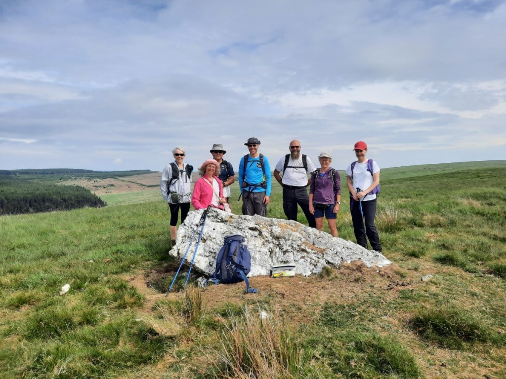
Naturally, I walked up with the faster members of the party. The radio operators spread themselves out across the grassy summit area and set up various elaborate antennae to score their SOTA points by contacting others from that summit. The hill baggers were content just to take in the views for a few minutes! Most were a lot further along their Marilyn-bagging journey than me, and it seemed most had travelled a lot further than me to tick off this obscure hill! Route map: https://www.plotaroute.com/route/3314218
The track up through Middle ParkThe summit of Upper Park
I walked down to the car with a few other baggers and set off to my next objective, Stingwern Hill, a few miles to the west. Verge parking on the lane just to the north of the summit allowed for a very short walk up and down a couple of fields to the summit with trig point and more views over undulating Welsh border country.
The view from Stingwern Hill, with Upper Park right of centre
My final hill for the morning was Caeliber Isaf, a few miles southwest of Montgomery. I parked on another grass verge, waited a little while for a shower to pass, then improvised a route south through a few fields to the grassy summit. A farm worker doing some fencing watched me from a distance but didn’t seem bothered by my walk across the farmland so thankfully no GOML was received! I dropped down west to a bridleway, then followed that track and the lane back to the car. Approximate route map: https://www.plotaroute.com/route/3314220
Looking west from Caeliber Isaf, with rain approachingGloomy skies as I approached the car
I ate my packed lunch in the car as a band of heavier rain set in, swiftly deciding (based on a radar check) that it was not worth taking a drive to any of my other unbagged Marilyns a bit further west. Accordingly it was just an early-afternoon drive back to Derby.
Four years have passed since I first attended a Gentian Club meet, and each of those years has started with a ‘Welsh Winter’ gathering in Eryri (Snowdonia). This year’s base was, as last year, the comfortable Capel Tanrallt bunkhouse near Penygroes, in the northwest of the National Park. Claire and I travelled together after work on the Friday, leaving my house at around 5:30, stopping for dinner at the services near Chester, and arriving at around 8:45. We unloaded, settled in, and chatted over a couple of drinks until bed.
Saturday’s forecast was for strong winds, gusting 45-60mph on the highest hills. As always, I was the weather optimist, and proposed a hill walk, hoping that the 700m peaks of the Nantlle Ridge would be low enough for the wind to be manageable. Claire, Ned and Sheena opted to join me, while all the others opted for lower level walks from the hut. We drove to the east end of the ridge, above Rhyd-Ddu, in my car. It was very blowy as we put our boots and coats on, but the wind actually didn’t seem to increase very much with height as we climbed steeply up to Y Garn, with improving views of Yr Aran and Moel Eilio.
Sheena and Ned, and Yr Aran
The rock was quite greasy but the wind not a major issue as we continued up the easy scramble to the summit of Mynydd Drws-y-coed, gaining better views south towards Moel Hebog. With the southeast wind generally either a crosswind or on our backs, we continued over Trum y Ddysgl then across the narrow grassy arete to Mynydd Tal-y-mignedd, with its prominent obelisk. There we found some good shelter behind a dry-stone wall for first lunch.
Claire on the rocky ridge up Mynydd Drws-y-coedTrum y DdysglThe ridge to Mynydd Tal-y-mignedd and Craig Cwm SilynClaire, Ned and Sheena on Mynydd Tal-y-mignedd
A larger grassy descent (in the wind) and rocky re-ascent (sheltered on the north side of the ridge) brought us to Craig Cwm Silyn, the day’s highest summit at 734m, This was followed by some easier walking along the nearly-level ridge to Garnedd-goch, where we paused briefly for second lunch by another wall. There were good views over Cwm Dulyn to the Lleyn Peninsula as we continued across Bwlch Cwmdulyn to Mynydd Graig Goch, our final summit of the day. There was a well-trodden grassy path down the northern slopes to the outflow of Llyn Cwm Dulyn, then a few kilometres of footpaths and lanes to get back to Tanrallt. Although the wind had been fairly strong and cold, it was mostly possible to walk steadily and there was never any risk of being blown over, so it was definitely the right decision to have gone out in the high hills! Route map: https://www.plotaroute.com/route/3211634
Looking back from Craig Cwm Silyn, with Yr Wyddfa (Snowdon) in the cloud in the distanceThe Lleyn Peninsula from Mynydd Graig Goch
Ned drove me back to Rhyd-Ddu to fetch my car. Once back at the hut, I refreshed myself with tea, biscuits and a hot shower, then relaxed until dinner. Ned had prepared a delicious cottage pie for the meat eaters, and Steve had brought a bottle of port to share afterwards. We had a good discussion of potential plans for the proposed Chamonix meet in July, and settled on a rough itinerary for the week, with a few day-walks followed by a few days of hut-to-hut touring on the Aiguilles Rouges.
Sunday was forecast to be a little warmer and have lighter winds, and we were pleased to find lots of blue sky near the west coast when we got up. I proposed a walk up Moel Hebog from Beddgelert Forest, and Ned, Vivienne and Claire opted to join me this time. Once we’d packed up our stuff and tidied the bunkhouse, we set off on the 15-minute drive to the free car park in the forest. It was nice and calm in the valley and actually felt pretty warm in the sunshine!
Sunshine over Nant Colwyn
The first couple of kilometres of walking were on tracks and bridleways through the forest, with one small detour near Meillionen where the path was closed for forestry works. From Cwm Cloch we gained the rough and sometimes boggy path up the northeast ridge of Moel Hebog – quite a long slog with nearly 700m of height to gain and stronger, colder winds higher up. As we climbed, there were beautiful views over Nant Colwyn and Nant Gwynant, and towards the Moelwynion with Cnicht, Moelwyn Mawr and Moelwyn Bach prominent. From the top, you could see down the coast towards the Rhinogydd, with Tremadoc Bay looking splendid in the sunshine. Surprisingly, the flat grassy area just north of the summit was very calm – I guess the easterly wind was separating off the top of the steep eastern slopes and going right over our heads!
Looking towards the MoelwynionClaire approaching the summit of Moel HebogLooking towards the Rhinogydd and Tremadoc Bay
After a short pause, we descended northwest on short, steep grass – thankfully dry and not too slippery – pausing for lunch in a sheltered corner near the bwlch. A short re-ascent led through some impressive crags to Moel yr Ogof. There we enjoyed some good views towards Snowdon, the cloud lifting for a little while to reveal significant snow coverage above about 900m. Crib Goch also peeped through the Y Lliwedd saddle in the sunshine.
Descending from Moel Hebog towards Moel yr OgofNed on the way up Moel yr OgofLooking back to Moel Hebog
A gentler final traverse led to the day’s final summit, Moel Lefn, from where we could follow a good, rocky path all the way down to the next bwlch where a public footpath crosses over. There were superb views to all the previous day’s summits on the Nantlle Ridge, and some interesting derelict mine workings in Cwm Trwsgl. The footpath gave very rough and boggy going through the rough moorland and felled forest all the way down to Hafod Ruffydd, where regained our outward route for the final few minutes back to the cars. Another cracking day out in the hills! Route map: https://www.plotaroute.com/route/3212629
Looking towards the Snowdon massif
We said our goodbyes and Claire and I had an excellect, clear drive back to Derby in just under three hours. A great first meet of the year for the Gentian Club, and now we look forward to March’s meet in Little Langdale. My full photo album can be found on Google Photos here.
Having enjoyed two trips to the Highlands in the past month, I decided not to head north of the border for Spring Bank Holiday this year. Instead I headed west of the border, to Wales! I based myself at the Tan-y-Fron campsite in Dolgellau, where I’ve stayed a couple of times before. Even leaving at 5pm on the Friday of Bank Holiday weekend, I wasn’t significantly delayed by traffic, the drive taking around three hours plus a dinner stop, so I was able to get pitched up before dark.
Saturday looked dry until evening, but with increasing winds and very low cloud. I started the day with a parkrun, choosing Y Promenâd parkrun, Abermaw as I thought it would be more scenic than the (much closer) Dolgellau parkrun! I had wondered whether the wind would slow me down on the sea-front, but it turned out to be just a light onshore breeze, and I was very pleased to finish in 18:37, my fastest time since 2019 and my second best age grade ever (73.32%)!
Barmouth Bay
Once I’d got my breath back and taken a few photos, I headed back inland for a walk up the Marilyn, Foel Offrwm, just north of Dolgellau. I was surprised to find a marked trail up the hill from the Precipice Walk car park. Even at just 405m, the hill was well in the cloud, so I didn’t get any summit views, but the woods were attractive on the lower slopes. I continued my walk by heading around the Precipice Walk itself, with a detour to the summit of Foel Cynwch (a Hump). The precipice was underwhelming, to someone who often walks above much larger crags! Route map: https://www.plotaroute.com/route/2987822
The path below Foel OffrwmLlyn Cynwch
I still had plenty of dry hours left, so I then took a drive east to the village of Aberangell, and from there up to the top of the high pass through Dyfi Forest. That gave easy access to nearby Mynydd Cymcelli, another Marilyn, which had some unusual earthworks around the summit and good views of Maesglase. Route map: https://www.plotaroute.com/route/2987859
Looking towards Maesglase from Mynydd CwmcelliEarthworks at the summit of Mynydd Cwmcelli
I took the slow route back to Dolgellau, continuing over the narrow pass through Aberllefenni to rejoin the main road at Corris. With rain expected by 6pm, I showered and cooked early, eating my pasta in the car as the first spots started to fall. It was a very wet evening, the rain eventually easing around 10pm to leave a dry night.
Sunday looked like it would offer the best weather of the trip, although still windy, so I planned a walk to include Cadair Idris. Walking directly from Dolgellau, I headed first to the nearby Marilyn of Moel Fynydd (shown on the OS maps as Craig y Castell). Lanes and tracks led most of the way but the summit ridge was rather unpleasant with even the sheep trods overgrown with bracken. At least it was less than waist deep at this time of year! A heavy shower fell as I approached the top. There were views towards the Rhinogs, Rhobell Fawr and the Arans, but Cadair Idris was cloaked in cloud.
A bit murky over the Rhinogs and Y GarnLooking towards Braich Ddu and Pared y Cefn-hir, from Moel Fynydd
I improvised a descent route very steeply south through the fields and then the forest towards Llyn Gwernan – pathless, overgrown and not recommended! However, I couldn’t see a better way to reach the bottom of the Fox’s Path up Cadair without a large detour or blatant trespass. The sky was brightening nicely as I set off up the grassy path – clearly not heavily used – and the steep buttress of Cyfrwy was almost clear above. I hadn’t been up that way before, and enjoyed passing by Llyn Gafr and Llyn y Gadair with fine views of the mountain’s northern crags.
Brightening conditions on the Fox’s Path below CyfrwyLlyn Gafr and the crags of Mynydd MoelLlyn y GadairCyfrwy from Llyn y Gadair
Even the final section up the scree to emerge on the ridge just east of Cadair Idris wasn’t anywhere near as loose as it looked, with a zigzagging path making its way up to the left of the main gully. Impressively, for a walk up Cadair Idris on a dry day of a Bank Holiday weekend, I didn’t pass a single other person until I reached the summit! It was very blustery on the highest ground, so I didn’t hang around long before setting off west to find a more sheltered spot for lunch above the crags on the way to Mynydd Moel. I continued east to Gau Graig then followed the obvious quad-bike track down to Bwlch-coch – familiar as Ruth and I had ascended that way on our Dragon’s Back backpack a few years ago. Route map: https://www.plotaroute.com/route/2988707
The Rhinogs and Llyn GafrThe ridge to Mynydd MoelCadair Idris from Mynydd Moel
Back in town before 3pm, I was in plenty of time to buy dinner supplies at the Co-op and had a leisurely evening chatting with a German couple who were backpacking the Snowdonia Way. There was a lovely sunset over the Rhinogs before bed.
Sunset at Tan-y-Fron
Monday was forecast to start bright and deteriorate around lunchtime, so I got an early start, up at 6am and on the road by 7. I was not a long drive around the eastern end of the Cadair Idris massif to Llanfihangel-y-pennant in the Dysynni valley, where I parked opposite the church.
I had planned a circular route that would link together a couple of Marilyns as well as the impressive (but not so prominent) Birds Rock. I followed the attractive bridleway east to the saddle at the ruined farmhouse of Nant-yr-eira, then climbed steeply south to gain the east ridge of Foel Cae’rberllan, surprising a few sheep and cows grazing among the bracken as I passed! It was a small and rather overgrown path beside the wall to the summit, but it was nice to traverse the full length of this shapely hill’s well-defined ridge. There were excellent views over the valley to Graig Goch, as well as towards Cadair Idris.
Graig Goch, and a glimpse of Tal-y-llyn LakeCadair Idris
The descent to Caerberllan farm was much easier, mostly on a well-made zigzag track. I followed the lane a short distance to Pont Ystumanner then re-ascended steeply on a footpath to gain the ridge of my next objective, Gamallt. This also gave excellent views, particularly back towards Foel Cae’rberllan and over Abergynolwyn to the Tarren hills. The actual summit, though, is over the fence into the forest, with no view at all!
Foel Cae’rberllanFoel Cae’rberllan, Abergynolwyn and the Tarrens
I improvised a descent of the forestry tracks towards Rhiwerfa, having to backtrack a bit and choose a different track when I encountered forestry machines working ahead – not what I had expected on a Bank Holiday Monday! Soon I was onto the main track, which I followed up to Bwlch-y-maen. From there, I found small paths over all three summits of Birds Rock, a popular family walk from the adjacent campsite, I think. The north top has impressive cliffs on its north side but I found they couldn’t really be appreciated from the summit!
Looking north from Birds RockLooking up the Dysynni valley
The first spots of rain began to fall as I descended back into the valley, but I made it half way back along the lanes to Llanfihangel before deciding a waterproof jacket was worthwhile. It didn’t seem to be deteriorating fast, so I decided I’d gamble on a second walk for a bonus Marilyn, Foel Cocyn, starting in Bryncrug. Although not a right of way, other baggers had reported no issues using the obvious zigzag track up the west ridge above Gwyddelfynydd, and so it proved for me – easy going for a quick yomp up and down, with views over the coast and Dysynni valley. Although the very light rain continued throughout, the strong breeze was drying me just as fast as I was getting wet, and I made it back to the car without needing waterproof trousers. Route maps: https://www.plotaroute.com/route/2989857 and https://www.plotaroute.com/route/2989862
Looking inland to Birds Rock and Gamallt, from Foel Cocyn
It was still only around 1pm. I drove up the coast to Fairbourne and ate my lunch in the car overlooking the estuary as heavier rain began to set in. That deterred any further exploration, so I headed straight back to Dolgellau, where I just spent the afternoon reading in the car! It was so wet that I took the lazy option and drove the half mile into town to get fish and chips for dinner. The rain only began to ease as I was thinking of heading to bed, around 9:30pm – one of the wettest eight-hour spells I can remember!
After a rather restless night, disturbed by squally showers, I got up early again on Tuesday. This time the forecast suggested it would start raining by 9am, so there wasn’t much of a weather window to play with, but I was keen to clear up my remaining two unbagged Marilyns in the vicinity. I decamped in little over an hour and was on the road just after 7am for the 20 minute drive around to near Aberangell.
My objective was Esgair Ddu, the highest point of the Mynydd Cemmaes massif. Most baggers had reported going up from the east, but their descriptions of awkward parking spots, and indistinct and overgrown paths didn’t really appeal, so I followed a small minority who’d gone up the west side of the hill. This proved an excellent choice, with a good layby to park in and attractive tracks that zigzagged up through deciduous woodland then steeper bracken-covered slopes to reach a grassy bridleway leading almost all the way to the summit. There were good views back over the Dovey valley to Maesglase, and a couple of red kites circled overhead near the summit. Route map: https://www.plotaroute.com/route/2991243
Looking over the upper Dovey valley to MaesglaseThe summit of Esgair Ddu, looking towards Carnedd Wen (in the forest)
The first spots of rain fell just as I started back down. I donned my waterproof jacket but, like the previous day, did not feel the need for trousers before reaching the car. A few minutes’ drive into the Banwy valley got me to Cae’r-lloi, the start point of my final walk of the trip. From a look at the radar map, I was pretty sure heavier rain would soon arrive, but I decided to go up the hill anyway. I knew that it was an easy walk up a large track all the way to the summit of Carnedd Wen and that I would be sheltered by forest on the upper half. I covered the 5km in just over an hour, and the descent a bit quicker than that, so didn’t have time to get totally soaked although the rain had been pretty persistent. Not much to say about the summit – just a trig point in a forest clearing. Not one to return to! Route map: https://www.plotaroute.com/route/2991247
A good track out of the Banwy valleyCarnedd Wen forest
The drive back to Derby was pretty slow with various tractors, lorries and minor jams, and wet all the way, but generally uneventful. Getting home by early afternoon, I was able to get most of my unpacking, sorting and drying done before bed, as well as writing this blog. The tent-drying will have to wait for a dryer day though!
My full photo album can be viewed on Google Photos here.
The 2025 ‘Welsh’ Winter’ weekend marks three years since my first trip with the Gentian Hillwalking and Mountaineering Club. I’ve been a pretty regular participant over that time, attending more than 20 meets, and this trip was a great chance to catch up with many of those who have now become good friends.
On the Friday night, I didn’t want to miss my annual pilgrimage to Worksop College to see Voces8 in concert, so my drive to Snowdonia was very early on Saturday instead. I left home at around 5:15am and, thanks to predictably quiet roads, arrived at the bunkhouse near Penygroes before 8am, in time to join in with the day’s route-planning session. The mountain forecasts suggested there could be an inversion at 700m so I decided to maximise the chances by going up the highest hill in the area, Snowdon (well, properly Yr Wyddfa these days!). Sheena, Claire and Ned joined me, while the others gambled on the forecast being spot on and tackled some or all of the Nantlle Ridge (with its highest peaks just exceeding 700m).
It was a short drive up the valley to Rhyd Ddu where there was plenty of roadside parking. We followed the start of the Rhyd Ddu path towards Snowdon but, rather than bearing left to climb to the Llechog Ridge, carried on up the old mine track to Bwlch Cwm Llan. There was only a little dissent among the group as we took the scenic detour (with 250m bonus ascent) to the summit of Yr Aran, the upper parts being in the mist but with some attractive hoar frost on the grass.
Old mine workings below Bwlch Cwm LlanLooking back across the bwlch to Allt Maenderyn and Cwm Llan
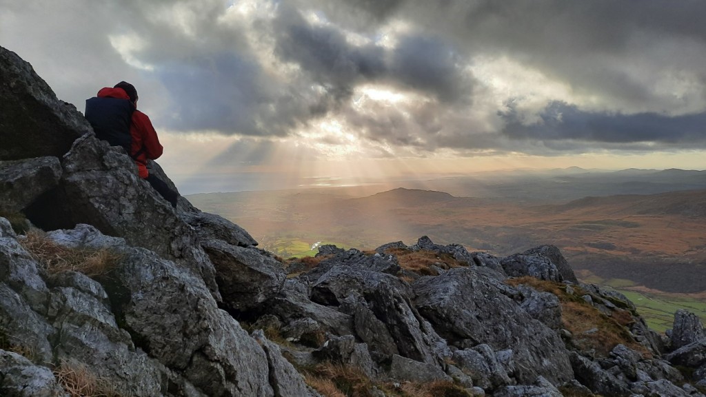
Then we returned to the bwlch and ascended the ridge over Allt Maenderyn, with a little easy scrambling in places, to rejoin the Rhyd Ddu path on Bwlch Main. Even there, at 900m, where some people descending had reported the inversion level to be, we had not escaped the mist, so I was beginning to feel unlucky. But just a little further on, around 950m, we did finally break out into sunshine. We took our time on the final approach to the summit of Snowdon, with lots of photo stops to appreciate the best inversion I’ve seen since 2023’s trip to Norway.
Above the clouds on Bwlch MainThe wider inversion southeast of SnowdonSheena, Ned and Claire below the summit
We found a relatively quiet spot on the east side of the summit – inevitably disturbed by a drone overhead – for a leisurely lunch overlooking Crib Goch and the inversion. The Glyders were also above the cloud, while the Carneddau were totally cloud free to the north.
The view from our lunch spot, with cloud cloaking Y LliweddCrib Goch, with the Glyderau and Carneddau beyond
It would have been easy to stay there longer in the warmth of the sunshine, but the dwindling daylight hours pushed us onward. We followed the main track down to Bwlch Glas with the tourists, then forked left onto the much quieter Snowdon Ranger path down Clogwyn Du’r Arddu, soon re-entering the mist, but getting back below the cloud at around 700m. Moel Cynghorion was just below the cloud base so we included that bonus peak on our walk, as planned.
Looking over Glaslyn and Llyn Llydaw from Bwlch GlasNed, Claire and Sheena at Bwlch Glas
An easy grassy descent took us to Bwlch Maesgwm, from where we followed the footpath fairly directly back to Rhyd Ddu. Beyond where it crossed the Ranger path, it was quite indistinct underfoot and boggy in places, although well marked with signposts. The evening sunshine beyond the Nantlle Ridge and Mynydd Mawr gave good views as we wiggled through the old quarries, and we got back to the car just before sunset. Route map: https://www.plotaroute.com/route/2855720 Our decision to go high was definitely vindicated when we discovered the Nantlle groups had not escaped the mist all day!
Sheena in the sunshine below Cwm ClogwynLate-afternoon sunshine beyond the Nantlle Ridge
Dinner for the meat-eaters was the ubiquitous (but tasty) pasta bolognese, with crumble and custard for dessert. Most of the group who’ve signed up for July’s hut-to-hut tour in the Stubai Alps were present, so we spent the latter part of the evening agreeing our itinerary and possible travel plans. After the very early morning, I didn’t stay up late!
Sunday was a greyer day, with the forecast again saying an inversion was possible at 800m. Although it would have been good to do the Nantlle Ridge when staying so close-by, it didn’t seem like there was much chance it would not be in mist all day. The Carneddau had the best forecast so, after we’d packed up our stuff and tidied the bunkhouse, I headed to the Ogwen Valley with Claire and Sheena. The others chose lower hills near the hut, near Beddgelert, and on the Lleyn Peninsula.
We followed the standard route – although new to Claire – via Ffynnon Lloer and the mildly-scrambly east ridge to Pen yr Ole Wen. The lower part of the scramble was made more interesting by a layer of verglas on the rocks! Chances of inversion didn’t seem good when the cloud base was not far below 900m, but we did at least get some good views over the lake and between layers of cloud in the Ogwen Valley.
Mist in the Ogwen Valley, from the path beside Afon LloerClaire and Sheena, high above Ffynnon Lloer
We continued over Carnedd Dafydd to Carnedd Llewelyn, getting views from the bwlchs but not the summits, and had lunch there next to the shelter cairn. Then we headed down the ridge of Penywaun-wen, soon dropping back below the cloud for some great views over Cwm Eigiau. A little bit of easy scrambling – not icy this time – led us to Bwlch Eryl Farchog. We descended south from there on the well-built zigzag path down to Ffynnon Llugwy, where there were excellent reflections of the snow-patch covered south-eastern slopes of Carnedd Llewelyn.
Cwm EigiauScrambling down to Bwlch Eryl FarchogReflections in Ffynnon LlugwyAwesome reflections
That just left an easy walk down the reservoir road and along the old valley road back to the cars. I was on the road by 4pm and home before 7 after another good drive. Route map: https://www.plotaroute.com/route/2855722
A wall-climbing sheep below Tryfan
In summary, another great weekend in the hills with friends. Dry and fairly calm weather with not much snow on the ground wasn’t particularly wintry, but was made particularly special by Saturday’s excursion above the clouds. Well worth the very early start to drive over on Saturday morning! You can find my full photo album on Google Photo here.
My plan for this weekend had been to attend the Gentian Club trip to the Ogwen Valley in Snowdonia, but sadly that meet was cancelled due to a problem with the bunkhouse. Instead, I headed to mid-Wales for a long weekend of Marilyn bagging.
On Friday morning, it was about a two-and-a-half hour drive to my chosen start point near Llanfihangel-nant-Melan. I arrived around 11am. My first objective, the only Marilyn of the walk, was Gwaunceste Hill. I followed bridleways up onto the plateau, past a stone-row and tumulus, then traipsed through rough heather for the final climb to the summit trig point. The skies had been grey to start off, but were already brightening nicely.
The summit of Gwaunceste Hill
To make a circular walk, I continued to a couple of nearby Humps. First up was Glascwm Hill, reached by an attractive grassy ridge then across the flanks of Little Hill. Then I headed east to the minor (but steep-sided) summit of Yr Allt. Four barky dogs greeted me intimidatingly at the farmyard to the west of the hill, and their owner came out to investigate. When I asked him if that was the line of the bridleway, he gave a disgruntled nod, got the dogs under control, and beckoned me through , then grumpily added “Don’t you have anywhere better to walk than through my b****y yard?”. I didn’t bother to explain that I’ve run out of better places and now have to climb obscure lumps and bumps in Powys to scratch my bagging itch! Anyway, Yr Allt was an attractive ridge with good views, and I had a late lunch on the summit.
The ridge towards Little Hill and Glascwm HillLooking back to Little Hill and Gwaunceste Hill, from Yr Allt
The final Hump of the day was Llanfihangel Hill, reached by the moorland ridge of Colva Hill, and covered in colourful heather and gorse. With not a tree in sight, I was surprised to encounter a squirrel near the summit! Descending to the west, I passed the very remote cottage at Pant-glas, which looked barely weathertight but surprisingly had three small wind turbines and a satellite dish! From there, it was only a short distance further to reach the well-worn byway climbing out of Cwm Ceste, and I followed that most of the way back to Llanfihangel. Route map: https://www.plotaroute.com/route/2745179
Heather and gorse on Llanfihangel HillDescending to remote Pant-glas
Once back at the car, I drove the few miles to Builth Wells, pausing at the Co-op for provisions before heading to the Noyadd Farm campsite a little south of town. This proved a good choice with nobody else staying on the tent field, good flat grass, and a handy picnic bench and tap next to my pitch. I had a quiet evening and, once it was dark, an early night.
I started Saturday with a tourist run at Groe parkrun, beside the River Wye in Builth. By chance it was their 200th event, but that didn’t seem to attract any more participants than usual – probably for the best as, even with just 99 runners, it was a little congested lapping the back-markers on the three-lap course. I managed 3rd place in 19:28.
Afterwards, I drove the short distance to Llanelwedd to start my main walk of the day. I began by ascending to the north over the old hill fort of Caer Fawr. From there, I made my way north across the plateau of Carneddau, taking a short detour to the trig point before going to the 445m Marilyn summit. Significant parts of the hill were covered in thick bracken, and the paths that I followed were unpleasantly overgrown in places. I was glad that there were grassier lines available for the descent towards Cilberllan!
Looking down to Builth WellsDescending through the bracken on CarneddauLooking ahead to Aberedw Hill
After a couple of kilometres on roads, I followed a footpath climbing steeply up the northern slopes of Aberedw Hill, pausing for lunch when I reached the ridge. A bit of misty drizzle passed over as I continued up to the trig point at the Marilyn summit. I descended via the Rhiw Rhwstyn ridge which gave a quick and easy route back to Llanelwedd. Route map: https://www.plotaroute.com/route/2745881
As it was only around 2:30pm, I decided to drive a few miles south for a bonus walk along the ridge of The Begwns, the highest point being another Marilyn. This broad ridge of bracken criss-crossed by grassy paths reminded me of parts of Dartmoor. The summit itself is within an incongruous small circular, wooded enclosure named ‘The Roundabout’. I picked a different set of grassy paths for the 3km return to the car. Sadly I didn’t get any views of the relatively-nearby Black Mountains as there was thin mist all the way. Route map: https://www.plotaroute.com/route/2745883
The Begwns
I went to the campsite to shower and change then popped into Builth to get fish and chips for dinner – particularly tasty despite not being near the coast! Rain was forecast for the evening but arrived a bit later than expected, around 8:30pm. I sat in the car for a while then got another early night. My sleep was frequently interrupted by the heavy rain but at least there was no wind and everything stayed bone dry inside the tent.
The rain had eased by morning, and conveniently it was only spitting as I had my breakfast and packed up camp. The forecast for the day looked very poor but I set off for Llangammarch Wells anyway for a walk up Mynydd Epynt. Actually I managed to get all the way to the summit before the rain started to increase, so I had some good views across the Irfon valley on the ascent.
Cwm Syfien and the Irfon valleyCwm Graig-ddu
The summit gave views towards the Brecon Beacons, with some of those distinctive peaks clear of cloud. It was pretty wet, but again windless, as I walked southwest along the edge of the plateau on the waymarked Epynt Way to reach the mapped monument – unremarkable close-up – and not much better for the descent via Troed-y-rhiw to the car. Route map: https://www.plotaroute.com/route/2746911
Distant views of Fan Gyhirych and the Black MountainsTroed-y-rhiw
Perhaps surprisingly, I had retained enough motivation to drive a short distance and set out for a short second walk of the morning, up the forested Marilyn, Pen y Garn-goch. On a brighter day, I’d have walked up from Llanwrted Wells, but this time I opted for the shortest option, zigzagging up forestry tracks from the east. A ride between the conifers gave easy access to the small summit clearing, which has a large ancient cairn and a trig point. I was glad I’d made the effort, as the rain had been very light throughout the walk. Route map: https://www.plotaroute.com/route/2746914
The summit clearing of Pen y Garn-gochLooking back across the Irfon valley to Mynydd Epynt
The drive home was very wet as far as Telford, then increasingly sunny. Back at home by 4pm, I was able to get the tent mostly dry in the garden, a load of laundry partly dry on the line, and the car washed, before dinner.
In summary, quite a productive three days of bagging, visiting six new Marilyns plus two Humps. These are very quiet, rolling hills with a colourful mixture of grass, heather, bracken and gorse, and not much exposed rock. The original plans in Snowdonia would have been rewarded with grander scenery and I think better weather though! My full photo album can be found here.
As ever, the first Gentian meet of the year was the ‘Welsh Winter’ weekend in Snowdonia. Also in-keeping with tradition, the Welsh winter looked like it would offer mainly extreme winds and heavy rain rather than snow, so as I headed west after work on Friday afternoon with Claire, I was doubtful whether we would manage much quality hillwalking! We arrived at the Rucksack Club’s ‘Beudy Mawr’ hut in Nant Peris soon after 7pm, settled in and cooked a quick dinner before an evening of conversation around the fire as the hut gradually warmed up!
Saturday’s forecast suggested the highest cloud levels and least rain would be found in the far northeast, so I offered to lead a walk from Abergwyngregyn up to Aber Falls and, weather permitting, Moel Wnion. Six others opted to join me, while the remaining four walked from the bunkhouse through the slate quarries to Deiniolen and Llanberis and back up the valley. It did seem brighter near the coast, and it was barely raining as we set off up the popular path to the impressive waterfall. I’m pretty sure I had not actually visited the falls before, and this was a good day to do so, after a wet night.
Heading for Aber FallsThe group below Aber Falls (Petra, Sheena, Mike, Claire, Simon and Jayne)
After a few photographs, we continued west on the North Wales Path, passing the smaller falls, ‘Rhaedr-bach’, then made our way up the valley of Afon Gam – hard work into a strong headwind! Once we were near the bwlch we swung right to have the wind behind us on the final ascent up the grassy dome of Moel Wnion. The summit shelter gave reasonable views up to the snowy tops of Foel Fras, with glimpses of Yr Elen and Carnedd Dafydd further away. It did look decidedly murkier over the Glyders!
Heading up Moel Wnion, with snowy Foel Fras in the background (Jayne, Sheena, Simon, Claire, Mike and Petra)Looking towards Yr Elen and Carnedd Dafydd
We descended the grassy slopes north then west to re-join the North Wales Path, with good views towards Anglesey and even a few patches of blue sky. Then it was just an easy walk back to the village, pausing for a late lunch in the relative shelter of the final zigzags. Route map: https://www.plotaroute.com/route/2495534
A little blue sky over the coast as we descended to Abergwyngregyn
We were back at the hut by mid-afternoon to warm up with a few cups of tea. The other group had had a much wetter day in the Llanberis valley, so I felt it had been worth making the drive. The evening was spent pleasantly over dinner, drinks and conversation.
Sunday looked like it would be even wetter and, problematically, even windier, with 100mph gusts expected on the higher tops. Nobody was inclined to attempt a Snowdonian peak, so we scattered to various lower-lying places: a few to Llangollen for a short walk up Castell Dinas Bran (but I wasn’t that tempted having been there in similar circumstances last year), a couple to the Anglesey coast, and Claire and I to the Clwydian Range.
It was a bit brighter further east but still very windy. My chosen route went up the sheltered side of the hills, fairly directly from Cilcain up to the summit of Moel Famau with its distinctive Jubilee Tower. The wind was pretty ferocious at the summit!
Claire at the summit of Moel Famau
We sheltered in an alcove of the tower to put on gloves and waterproof trousers, then set off north along the ridge. The gusts made for tortuous and unsteady walking but did ease a little as we dropped down and crossed Moel Dywyll. Then it was just a short walk back down to the village via the small reservoir at Garth. The rain had stopped again, so we had lunch outdoors in the churchyard before setting off back to Derby. Route map: https://www.plotaroute.com/route/2495536
Claire by the reservoir above Cilcain
Overall, a disappointing weekend of weather, the winds not permitting any high peaks to be climbed, but it was still good to catch up with the other Gentians over walks and in the hut. There are a few more photos here. Looking forward to the next meet, to Borrowdale in March.
My first Gentian weekend of the autumn took me back to a bunkhouse I had previously stayed in in 2007 and 2012 with CUHWC: the Stafford Mountain Club’s cosy Bryn Hafod hut at the head of Cwm Cywarch, near Dinas Mawddwy. I was looking forward to refreshing my acquaintance with the place, and to seeing the regular club members again, a few months having passed since the last trip.
I took the Friday off work to spend an extra day in the hills. Claire had arranged to get a lift to Wales with me and met me at my house at 9am. The drive west was without significant delay, and we met Sheena in a layby near the bottom of Arenig Fawr soon after 11:30. The weather didn’t look promising so we got our waterproofs jackets on from the start, heading back along the lane for a mile or so, then along the good track to Llyn Arenig Fawr. There we chatted briefly with a couple of men who were whitewashing the inside of the tiny MBA bothy by the dam.
We continued up the well-walked path up the ridge of Y Castell, soon pausing to put on waterproof trousers as the mist was very damp and carried a little light rain with it. Sadly we didn’t get any views higher up the hill. We were surprised to see one other walker going up and two coming down. We paused for a late lunch in a sheltered spot below the ridge, then made our way up over the final craggy section to the trig point and memorial to the American airmen killed in a plane crash on the hill in WW2.
Ascending to Arenig Fawr
The south-westerly wind was pretty severe on the summit ridge, so we abandoned our plan to continue to Moel Llyfnant and instead returned by our more sheltered route of ascent. The cloud had lifted slightly to give somewhat better views over the lake, but there wasn’t much else to note. Anyway, it’s always good to get out on the hill! Route map: https://www.plotaroute.com/route/2412126
Claire and Sheena by Llyn Arenig Fawr
The drive over the steep and narrow Bwlch y Groes road to Cwm Cywarch took around 40 minutes, after which we made two trips on foot from the car, half a mile up the valley to the bunkhouse, to carry all the luggage and provisions in. Ted, Martin and Mick had arrived a short while earlier, and the six of us were the full complement for this trip! Ted cooked an evening meal for us, enjoyed over wine from the Gentian bar as ever.
I was on breakfast duty for the weekend, so rose a few minutes earlier than the others on Saturday morning to prepare the porridge and toast. After that, with the bunkhouse being so well located at the foot of the hills, we all opted to walk directly from there. I led Mick and Claire on a clockwise route over Glasgwm and Aran Fawddwy, while Ted led Martin and Sheena on an anticlockwise one going further north to Aran Benllyn but omitting Glasgwm.
Setting off from Bryn Hafod
We ascended by the good zigzagging track below the dramatic crags of Craig Cywarch to the minor summit of Y Gribin, then continued north up the fence-line to Glasgwm, which has a small tarn near the summit cairn. Although we didn’t have any views up to this point, it was clear that blue skies were not far away, as we had glimpses of them from the top.
Ascending below Craig CywarchCwm CywarchSunshine overhead on Glasgwm
The descent north was quite steep and rocky, which Mick found tricky. By the bottom, he had decided that it would be better if he left Claire and me to walk ahead to Aran Fawddwy while he took the more direct route down over Drysgol. We continued together, enjoying increasing breaks in the cloud, as far as Gwaun Llwyni, where we paused for lunch in the sunshine with a grand view down Cwm Cywarch.
Lunch overlooking Cwm Cywarch
Then Claire and I walked more briskly up the ridge to the rocky summit of Aran Fawddwy, its trig point poised dramatically above the eastern cliffs that plunge down towards the waters of Creiglyn Dyfi. We paused for a while at the summit to take in the excellent views in all directions, particularly towards Cadair Idris and the Rhinogs. The high hills of northern Snowdonia remained in the cloud though.
Creiglyn Dyfi, below the cliffs of Aran FawddwyAran Benllyn, from Aran Fawddwy
We descended by good paths over Drysgol, then over much rougher, boggier ground to the head of Cwm Terwyn to pick up the southern of the two public footpaths shown on the map. Although its line was very clear on an easy-angled, man-made terrace, the going was disappointingly awkward through tussocky grass and reeds, and rather boggy in places, so we were glad to make it down to the easy ground by the farm at Ty’n-y-maes. From there, it was an easy mile or so back up the lane to the bunkhouse.
HengwmCwm Terwyn
By chance, we caught up with Mick right at the bottom of the Hengwm path (by which he had descended) and walked the final few minutes together, arriving around 6pm. We enjoyed tea, cake and hot showers while we waited for the others, who got back an hour later, making full use of the available daylight! Route map: https://www.plotaroute.com/route/2412130
The evening meal consisted of soup provided by Ted, followed by an excellent beef curry prepared by Mick for the meat-eaters, and Sheena’s crumble for dessert. All very tasty and filling! We chatted around the fire until retiring to bed a bit before midnight.
After Sunday breakfast, we all spent some time packing our stuff and tidying up the hut. Claire had expressed interest in a walk up Rhobell Fawr, and I was happy to oblige, it being more than 10 years since my last ascent. The others opted to walk from the hut again, up Glasgwm and Pen y Brynnfforchog, so we said our farewells before setting off for the 20 minute drive to the village of Rhydymain.
This time it was sunny from the start of the day. We ascended on good tracks up the southern flank of the hill to about 450m, before striking off up the steep, grassy and rocky slopes for the final 300m climb to the summit. This side of the hill is more impressive than the north side from which I approached previously!
A mossy wall above RhydymainClaire, and the southern crags of Rhobell Fawr
As we climbed, Aran Fawddwy dominated the view to the east, while the ridge of Cadair Idris looked impressive to the west. Then from the summit, most of the other hills of Snowdonia came into view. We admired the distinctive outline of the Rhinogs, and could clearly see Moel Hebog, the Nantlle Ridge, Snowdon, the Glyders and the southern Carneddau in the distance to the northwest. Arenig Fawr, which we had climbed on Friday, was not far away to the north too.
The view towards Cadair IdrisLooking north to Moel Hebog, the Nantlle Ridge, Snowdon, the Glyders and the CarneddauThe Rhinogs
We descended a short distance to find shelter for lunch, then continued down a grassy path to the edge of the forest to the east. We followed the signposted, but very boggy, rides through the forest to reach the open ground the other side for a very rough ascent over tussocky grass and heather to Dduallt.
Looking back to Rhobell Fawr, with Cadair Idris beyond
After taking in the views there for a few minutes, we weren’t very keen to return to the saddle the same way, so gambled on a descent along the fence-line northwest. This turned out to be much easier underfoot, with another (less wet) forest ride providing an easy escape to the track at the bottom. That just left a few miles of easy track and lane walking, over the ridge and back down to Rhydymain, arriving around 5pm. Another clear drive got us back to my house before 8pm, giving plenty of time to eat, shower, unpack and get things sorted ready for the working week. Route map: https://www.plotaroute.com/route/2412133
It was great to spend another weekend with the Gentian Club, and to return to some excellent hills that I hadn’t been to for ages. I look forward to the Annual Dinner next month! As ever, my full photo album can be enjoyed on Google Photos, here.
This month’s Gentian weekend trip went to the quiet and remote hills of Mid-Wales, staying in the rustic, off-grid hostel at Dolgoch. Unusual for me to spend a weekend so relatively close to home in so unfamiliar an area! Claire, a recent new member from Nottingham on her second club meet, had asked to share a lift with me so we both got an early finish from work on the Friday afternoon and met at my house at 3pm. Conversation made the journey pass quickly and the traffic didn’t cause major delay so, after a stop for fish and chips in Knighton, we arrived at Dolgoch soon after 7pm.
I slept fairly poorly in the unfamiliar bed of an excessively warm dormitory. We gathered for breakfast together, as usual, at 7:30am, then shared our route ideas for the day. Mick and I had actually come up with near-identical plans to head up Drygarn Fawr, but agreed that it was best to keep it as two groups, mine faster and his a little more leisurely. Seven others decided to join me.
We walked directly from the hostel, ascending via the easy forest tracks up to Bryn Crwn, then up easy grassy slopes onto Drum Nantygorlan, which had an unusual large block of quartz at its summit. The large summit cairn of Drygarn Fawr was just visible, pointing above Drum yr Eira to the east.
The view from the hostelThe group on Drum Nantygorlan: Julia, Anne, Martin, Rich, Simon, Sheena and Claire
I had imagined we would head fairly directly across the valley of Nant y Rhestr towards Drygarn Fawr, but given the fair weather we opted instead for a more circuitous (but gentler) route via Cerrig Llwyd y Rhestr. Rough paths led us up to that craggy top, then a quad-bike track led us back south along the ridge past numerous boundary stones. After many weeks of dry weather, the bogs were very firm and progress was unusually easy!
Dry bogs on the ridge to Drygarn Fawr
Soon we were at the summit of Drygarn Fawr, passing the trig point to reach the huge beehive-shaped western cairn. Simon and Claire followed my example by climbing the cairn, while the others were content to watch from below. Then we had a leisurely lunch with hazy views of the Brecon Beacons to the south, and Plynlimon to the north. A few other walkers passing the summit were the only others we would see all day.
Simon on the cairnThe group on Drygarn Fawr
After lunch, we took a scenic detour along to the second large cairn at the east end of the summit ridge, with its distinctive white top, then returned to the main summit. We descended southwest, following the well-worn path to the edge of the forest, as Ruth and I had done on our backpack of the Dragon’s Back race route a couple of years ago. Keen to avoid the heavily-overgrown bridleway down to Llanerch-yrfa, we took the forest tracks on the other side of the valley – not strictly a right of way, but clearly well used.
Llanerch-yrfa Forest
Rather than follow the Devil’s Staircase road all the way back to the hostel, we took a slightly extended route to the top of the pass via some forest tracks on the north side, which just left around 1.5km of descent on the tarmac. We had made good time and were back at the hostel soon after 3pm for tea and good solar-heated showers. A dense congregation of midges soon drove us indoors after we had initially sat on the rear terrace overlooking the river! Route map: https://www.plotaroute.com/route/2290934
The evening followed its usual format, with a three course meal accompanied by drinks from the Gentian bar, then conversation and a bit of ceilidh music by John, Sue and Sheena in the later evening. I headed to bed around 10pm, finding the dormitory less hot than the previous night, but for some reason I didn’t sleep significantly better!
After Sunday breakfast, we did a bit of cleaning and tidying before setting off on our walks for the day. This time, I offered a circular route starting a short distance west of the hostel, taking in a section of the Cambrian Way, while Mick proposed breaking the drive home with a walk up the Radnor Forest hills. Four opted to join me, and we reconvened at the summit of Bwlch Esgair Gelli after a few minutes’ drive.
The walk started easily with a descent of the quiet road towards Nantymaen. There we picked up the Cambrian Way – totally pathless and unevident on the ground – over the undulating ridges of Esgair Cerrig and Esgair Wynt.
Claire, Rich, Sheena and Anne on Esgair Wynt
Beyond there, we reached the end of a better track down the Doethie valley. After a mile or so, we passed the hostel at Ty’n-y-cornel, Dolgoch’s twin hostel, and took advantage of its public tea-making facilities before having first lunch on the terrace and a bit of a chat with the warden.
The next section of the walk, following the Doethie valley downstream, was the most attractive of the day. Shortly after leaving Ty’n-y-cornel, we left the heavily-eroded byway to follow a more attractive contouring bridleway across the bracken-covered slopes below Foel Fraith. We passed a few backpackers heading the opposite direction. A few rolls of thunder were audible in the distance, but never brought rain. The steep valley gave excellent views in both directions, with scattered deciduous trees around the river, and larger coniferous plantations further downstream.
The Doethie valleyClaire in the Doethie valley
We then climbed steeply up to the left to pass over the ridge to Nant-llwyd and continued along bridleways from there to the small chapel at Soar y Mynydd. It was a nice surprise to find a church service in progress, the visiting congregation singing with characteristically-Welsh gusto (and in Welsh). We paused for second lunch nearby but were soon driven away by gathering midges, and followed the lane north for a couple of kilometres below the forest of Esgair Ganol. To return to the cars, we headed up the grassy slopes onto the broad ridge of Gamallt, tussocky in places, but with intermittent sheep trods and quad-bike tracks to help our progress. A heavy flurry of rain sent us diving for our waterproofs, but petered out before we’d finished putting them on! Route map: https://www.plotaroute.com/route/2290936
Looking back down into the Doethie valley
Back at Bwlch Esgair Gelli, we said our goodbyes then set off back home. I had offered Sheena a lift back to Wolverhampton to enable her to join our group for the day, so that was the first stop, before dropping Claire back to her car at my house. TMS coverage of the first Ashes Test provided the entertainment, despite rain having stopped play! It stayed dry in Wales but was pretty wet through England – welcome rain for the plants and reservoirs!
In summary, another very enjoyable weekend away with the Gentian Club. It was great to explore a new area, the remote Doethie valley being a particular highlight. Think I’ll have to wait until October for my next similar weekend away though!
The Gentian Club’s first weekend trip of 2023 went to the Oread Club’s ‘Tan yr Wyddfa’ bunkhouse in Rhyd Ddu, west of Snowdon – a place I had stayed as an undergraduate with CUHWC. I have a few days of 2022 annual leave to use up by Easter, so I took the first of them on Friday to make it a three day weekend. I had advertised my intention to walk on Mynydd Mawr on the Friday, and Simon had decided to join me, and also offered me a lift from his home in Walsall. A pretty early start was required to get to his house around 7:45am for the three hour drive to west Wales. Google directed us around the traffic by recommending the scenic route via Bala and Trawsfynydd.
We parked in Nantlle village and were walking just before 11am, following the Slate Trail around the south side of Llyn Nantlle Uchaf and up the valley. We then zigzagged back left onto the ridge of Mynydd Mawr, enjoying dramatic views over the crags of Craig y Bera on the final section towards the summit. Sunny spells gave dramatic light conditions over all the surrounding peaks, although Snowdon was in cloud.
Snowdon and Yr AranCraig y BeraSunshine over the Nantlle Ridge
We descended northwest to cross the boggy bwlch and reach the minor summit of Moel Tryfan – a HuMP I had not previously visited. The hill is heavily scarred by disused and active slate quarries, but still gave good views. We then rejoined the Slate Trail for the return leg to Nantlle, finishing around 3:30pm.
The view from Moel TryfanSimon above Nantlle village
After a short drive east, we reached the bunkhouse slightly before the appointed arrival time of 4 o’clock to find a few others also just arriving. With a few attendees having dropped out in the preceding few days, the bunkrooms, lounge and dining area were fairly spacious for the ten of us, and the temperature gradually rose as the coal fire burned! I had fresh pasta for dinner before an evening of chat and a couple of glasses of wine.
On Saturday, I led a walk up Moel Hebog, for which I was joined by Simon, Petra, Sheena and Martin. The day had started fairly wet, but it was petering out by the time we set out from Rhyd Ddu, and a couple of light showers in the first half hour of walking were the sum total of rain during our walk. The skies gradually brightened as we followed the Slate Trail south through Beddgelert Forest towards Beddgelert. About 1km short of the village, we turned right to ascend the well-trodden path up onto Moel Hebog, with improving views towards Snowdon – which emerged from the cloud for an hour or so – Cnicht and the Moelwyns. We had lunch in the shelter of a small crag about two thirds of the way up, before the final steep climb between the crags to the ridge.
Yr AranLooking towards Cnicht and the Moelwyns
The summit gave great views both south to Porthmadog and north to the subsidiary tops of Moel yr Ogof and Moel Lefn, with the Nantlle Ridge. However, with a strong and cold wind, we didn’t linger long before starting the descent north. Once we were down at the bwlch, Martin opted to descend east from there back to the forest tracks, while the other four of us continued along the ridge. Short ascents with a little easy scrambling here and there led us up to each hill. The clouds generally got greyer and the wind strengthened noticeably, but there were still dramatic light conditions over the coast, seen best from Moel Lefn.
Descending from Moel HebogMoody skies over Moel LefnLooking out to the coast from Moel Lefn
A steep and fairly rough descent eventually brought us to the shelter of the forest, and easier walking on tracks and good paths back to Rhyd Ddu where we were glad of tea, cake and showers. In the evening, Simon cooked a tasty and filling beef casserole for the meat-eaters, followed by Petra’s bread and butter pudding.
Sunday started very wet, and with low cloud shrouding all the summits. Nevertheless, I trusted the forecast, which only predicted showers, and proposed a linear walk along the Nantlle Ridge, from west to east to have the wind behind us. Simon and Petra chose to join me, while the others mostly did a walk along the Slate Trail from Waunfawr back to Rhyd Ddu – part of which Simon and I had done on Friday.
Simon drove us to the start but, unfortunately, hit a large pothole hidden in a puddle near the top of the low pass, puncturing his front offside tyre. That meant a short stop to change the wheel in the cold rain before we could continue to our start point near Talysarn. The walk started on what turned out to be a very little-used footpath up through trees, undergrowth and a small quarry. It was good to reach the open land above, which gave easier walking with less careful navigation required!
Petra and Simon escaping the undergrowth above Talysarn
We passed the ruined cottage of Brynllidiard and continued up beside the crags of Cwm Silyn. Sadly the thick mist meant we couldn’t see the lakes in the combe below. A light shower blew through as we approached the summit of Craig Cwm Silyn, and I put my waterproofs on in the shelter of one of the large cairns. The descent to Bwlch Dros-bern proved to be the most awkward of the walk, thanks to the patchy covering of slushy snow on the boulders.
After the short but steep reascent to Mynydd Tal-y-mignedd, we paused for lunch at the summit, which was surprisingly sheltered – or perhaps the wind had just dropped – before continuing on the narrower sections of ridge to Trum y Ddysgl and Mynydd Drws-y-coed. Although we never dropped out of the mist, the terrain is interesting enough to be enjoyable even without a view. Soon we had reached the easier ground of Y Garn, which just left the descent of the eroded path back to Rhyd Ddu.
The summit of Mynydd Tal-y-migneddMynydd Drws-y-coed
We were the first back, at least an hour before the slower-moving group on the Slate Trail, so made a good start on the cleaning and tidying while we waited. Unfortunately, Petra had inadvertently left her car keys in Simon’s car, so we were unable to collect it from Talysarn until the other drivers arrived back from their walk to rescue us! In the end, Simon and I set off home around 6pm and had a smooth journey back to Walsall, and then (for me) on to Hilton.
Overall, three good days on the hill with great company. Weather-wise, we got away pretty lightly considering the forecast each day had been for strong winds and heavy showers. Most of the heaviest rain fell overnight, and we had had summit views on two days out of three. I look forward to the next weekend trip, to the North Lakes in March.
My full photo album is available on Google Photos here.
Following on from the ‘Welsh Winter’ meet in January (at which we organised our own accommodation independently due to Covid restrictions), I joined the Gentian Mountaineering and Hillwalking Club again for a more typical weekend trip, staying at the Ceunant Mountaineering Club hut, Ty’n Lon, in Nant Peris. I got an early dinner at home then drove across to Wales, not encountering much traffic and arriving at the bunkhouse in around 2h45. Having settled in and been introduced to the group, we spent the rest of the evening chatting over tea and wine before getting to bed by 11pm-ish.
The next morning we shared a communal breakfast at 7:30am and then made walking plans for the day. Noting that the MWIS forecast said the worst weather would be in the west, I proposed a short drive east to Bethesda for a horseshoe route on the Carneddau. Sheena decided to join me, two others chose a lower-level option near Capel Curig, and the remaining five walked from the bunkhouse up Y Garn and Elidir Fawr (very similar to the route I’d done with Mike and Stuart on the January trip).
We parked on the main street and, after a couple of kilometres making our way up to the top of the village, emerged onto the open hillside. After a slightly boggy and tussocky start, the going soon got easier and, as the ridge to Yr Elen became better defined, turned into a fairly clear path. We made good progress uphill, past the craggy crest of Foel Ganol, then more steeply up the final rocky slopes to emerge very near the summit. We had watched a couple of showers pass over Y Garn and down the Ogwen Valley, and were pleased that they had missed us (but suspected the other group had not been so lucky!). The summit of Yr Elen was a great viewpoint, east to Foel Grach, southeast over Ffynnon Caseg to Carnedd Llewelyn, southwest towards the cliffs of Carnedd Dafydd with Elidir Fawr beyond.
The Y Garn ridge, from above BethesdaSheena on Foel GanolThe summit of Yr Elen, and Carnedd Dafydd beyond
Soon after we set off towards Carnedd Llewelyn, a short but heavy shower passed over, lasting about 15 minutes. Once we reached the top, the rain had stopped, so we paused for lunch in the summit shelter, where we were joined by one other walker who had come up from the south. We were surprised not to see more people up there on a summer Saturday!
Just below the cloud at the summit of Carnedd Llewelyn, with brighter conditions an Anglesey in the distance
From there, our route turned north along the ridge to Foel Grach (in another sleety shower) and then Carnedd Gwenllian (dry again), mostly on a good path, with good views back towards Yr Elen and Carnedd Llewelyn as the weather became sunnier.
Yr Elen
Then we descended west, taking in the attractive rocky tors of Yr Aryg and Bera Bach, then the more rounded (but still rocky) summit of Drosgl. As the afternoon was brightening, we opted for the longer of our two possible descent routes, via Gyrn and Moel Faban, which gave us more excellent views towards the Ogwen Valley and Anglesey.
Looking back from Yr ArygSheena on Bera Bach, and a shower in the Ogwen ValleyLooking over Bethesda to the Glyders in afternoon sunshine
We were back in Bethesda by 4pm and back at the bunkhouse soon after 4:30pm having failed to obtain the updated MWIS forecast (but seen that the regular weather forecast for the Sunday was terrible!). I refreshed with a few cups of tea and a shower, then we all headed next door to the Vaynol Arms for an hour or so, before returning to the bunkhouse to cook dinner and eat. Martin did a tasty chorizo pasta dish for the meat-eaters, and Howard had brought strawberries for dessert.
True to the forecast, it was an increasingly windy night and Sunday dawned very wet. Five of the group had seen enough out of the window by the end of breakfast, and decided to head straight home. The remaining four of us agreed to drive east for an hour or so and reconvene in Llangollen, where it sounded like the weather should be better.
We were in luck, with the rain gradually getting lighter away from the coast. Sheena, Martin and I set off on a longer walk on an improvised route without paper maps, while Ted went for a more leisurely outing. We started by ascending fairly steeply up to Castell Dinas Bran, impressive castle ruins on a hilltop, with good views over the Vale of Llangollen and the hills to the north.
Creigiau Eglwyseg, from Castell Dinas Bran
We dropped down the other side of the hill to pick up the Offa’s Dyke Path along the foot of Creigiau Eglwyseg, impressive limestone cliffs more reminiscent of the Yorkshire Dales than North Wales! We continued as far north as World’s End, with a pause for lunch, then made our way back southwest via lanes and footpaths to Valle Crucis Abbey, from where we could pick up the canal towpath back to Llangollen.
A dry river bed below Creigiau EglwysegSheena and Martin
We enjoyed ice creams as we walked back through town – not how I expected the day to end after the miserable weather at the start – then parted ways. An hour and three quarters of quiet driving brought me back home to Hilton.
A great weekend in the hills with scenic walks, good company and good food, very similar in many ways to the CUHWC trips of student days. Looking forward to a couple more weekend trips in the autumn!
I decided to try out a trip with the Gentian Mountaineering and Hillwalking Club, which seemed like it might be more focussed on hillwalking and less on rambling or rock-climbing than many other clubs, and have members mostly based in the Midlands. Due to the Covid situation, this ‘Welsh Winter’ meet was not based in shared bunkhouse accommodation, but a more informal affair where attendees each found their own places to stay and just met each day for walks. With a few days of carried over 2021 annual leave needing to be used by Easter, I was happy to take the Friday and Monday off to make it four days in the hills. I based myself at the Vagabond Bunkhouse, more of a hostel really, in Betws-y-Coed, which proved to be quiet, economical and convenient but rather chilly!
On the Friday, I had arranged to meet up with Mike and Stuart, two long-time Gentian members, for a walk up the northern Glyderau from Nant Peris. We parked at the Park and Ride car park and soon set off up the footpath up Cwm Cneifio as we got to know each other, with good views towards Crib Goch.
Looking towards Crib Goch and Crib y Ddysgl
Soon after passing Llyn y Cwn, we entered the cloud, which was gradually dropping after a fairly bright start. The top 100m or so of Y Garn had a light covering of snow and rime, and there was the remains of a cornice on the eastern edges of the ridge. Sadly we remained in the cloud as we continued north over Foel-goch and Mynydd Perfedd to the rocky summit of Carnedd y Filiast, finally dropping out of it as we descended towards Marchlyn Bach, revealing good views north over Anglesey.
Mike and Stuart on Carnedd y Filiast
Our descent was on zigzagging tracks through the abandoned Dinorwic slate quarry, which had lots of interesting and dramatic sights to enjoy up close, as well as good views over the valley to the Snowdon range. Afterwards I joined Stuart for a cup of tea at the MAM hut, Glan Dena, where he was staying, before returning to Betws-y-Coed for dinner.
Saturday’s group walk offering was a little short for my taste, on the northernmost reaches of the Carneddau, and nobody else was tempted by my offering on Snowdon. I chose to do my own thing anyway and stuck with my advertised plan, starting in Llanberis. Again, the day started quite bright but the cloud dropped progressively through the morning. Moel Eilio was clear as I set off from the village, but well in the cloud by the time I reached the summit about an hour later. I did drop out of the cloud at the saddles before Foel Gron and Moel Cynghorion at least.
Early morning sunshine through the Llanberis PassMoel Cynghorion
Once over Moel Cynghorion, I joined the Snowdon Ranger path and followed that the rest of the way up Snowdon, reaching the snowline at around 900m and joining the masses where the path converged with the popular Llanberis and Pyg/Miners tracks. An icy cold wind and dampness in the cloud encouraged me not to linger for long at the summit, which was a shame as I could see blue sky above and suspected that lingering might have yielded views if the cloud were just to drop by another few metres! So once I’d donned an extra layer and had some lunch in the lee of the café building, I marched off down the Llanberis path, parallel with the railway (not in operation at this time of year, of course), overtaking plenty of others as I went. Brisk walking and not many stops meant the full walk had only taken me five hours!
I had a leisurely afternoon reading back at the hostel, then met up with a few of the others for dinner at the Plas y Brenin outdoor centre – something I did not previously know they offered to non-residents!
On Sunday, I met up with Mike and Stuart again for a walk that Mike and I had, by chance, independently suggested, around Cwm Eigiau in the eastern Carneddau. As it was a fairly long route, we convened just before 8:30am to make the most of the available daylight. Surprisingly, the small car park at the head of the road was almost full at this early hour!
After an easy approach to Llyn Eigiau along tracks, the initial ascent was on small trods through rough heather onto the north ridge of Pen Llithrig y Wrach. Once we’d passed the northern top, the path became better defined and made for easier going the rest of the way to the summit. We enjoyed fine views over Cwm Eigiau and the route ahead, although Carnedd Llewelyn was in the cloud.
Ascending above Llyn EigiauPen yr Helgi Du ahead
After a snack by the summit, we continued west, dropping steeply then reascending the craggy ridge to Pen yr Helgi Du. The descent west from there required a little easy scrambling, with dramatic views over Ffynnon Llugwy below, before the final ascent up to Carnedd Llewelyn. We entered the cloud not far above the saddle, but could tell at times that there was brightness above and I remained hopeful that the forecast possibility of an inversion might be right. Sure enough, only around 50m below the summit, we did emerge into the clear sunshine to enjoy all-around views over the cloud as we had our lunch. No other peaks seemed to be consistently clear, with only brief glimpses of Carnedd Dafydd to the southwest, and surprisingly none of Snowdon beyond that.
Descending from Pen yr Helgi DuInversion around Carnedd LlewelynMike and Stuart at the summit of Carnedd Llewelyn
We followed the easy-angled ridge north over Foel Grach and Carnedd Gwenllian, then made a pathless descent northeast over easy grass to outflank the crags and steep ground before turning south to reach the pretty hidden lake of Dulyn. A couple of dramatic waterfalls tumble down the cliffs into the northern end of the lake. A short final re-ascent led us to Melynllyn, from where an easy track led us all the way back to the cars. A fantastic day out in the high hills!
On Monday, I finally got the chance to meet all the rest of the Gentian members on the trip, as we all walked together up Moel Siabod. The forecast was for a grey day with low cloud, so I wasn’t hopeful of many views and, sure enough, we didn’t have to ascend far before we entered the murk. We traversed the eastern slopes of the hill, past a couple of small lakes, to reach the bottom of the Daear Ddu ridge, a pleasant easy scramble leading directly to the summit.
To my surprise, it soon became clear that there was blue sky not far above us again, and we were really pleased to break out into the sunshine at around 700m! The peaks of Cadair Idris were visible in the distance to the south, along with others less far away to the southwest – Moelwyn Mawr and Moel Hebog perhaps. We also enjoyed seeing lots of Brocken Spectres to our right, with the cloud below us in the cwm above Llyn y Foel.
Daear Ddu above the cloudBrocken SpectreDeb on the ridge
Once we’d clambered up the remainder of the ridge, the summit of Moel Siabod gave even an better panorama, with the high Snowdonian peaks of Snowdon, the Glyders and Carneddau coming into view. We had lunch in the warm sunshine by the summit trig point, with not a breath of wind to chill us. Then, having said my goodbyes, I made a brisk solo descent of the north ridge then tracks and paths through the forest and along the river back to the start, to make sure I was back in Derby in time for band rehearsal. Not long until the Midlands Championships!
Snowdon, the Glyders and the CarneddauLooking towards SnowdonInversion, from Moel SiabodDeb, Mick, Mike, Stuart, Sheena, Ted, Simon and Danni
All in all a very good weekend away enjoying time in the hills with like-minded companions. Even though many of the members are significantly older than me, it felt like we had plenty in common, and I look forward to trying one of their more normal bunkhouse meets at some point later in the year. The cloud inversions on Carnedd Llewelyn and Moel Siabod make it truly a weekend to remember!
With a little bit of annual leave to use up, I took Friday off work to make a long weekend trip to the Welsh Valleys, an area with quite a few hills of 400-600m, many of them Marilyns, but which I’d barely visited previously.
After an early-ish start from Derby and a good clear drive, I started walking from Abertillery at around 10:15am. My route started up the bridleway to Arail, where the owner, driving up, challenged me where I was going and why! He obviously doesn’t get many walkers passing through, and grumbled that he ‘didn’t really like people walking through the yard’, but clearly knew it was a right of way really and didn’t actually try to stop me. Soon I was on the open ground of the ridge, initially on the west side overlooking Cwm Big, and later on the east with good views of Abertillery and Blaina below.
Abertillery
After a few miles, a short detour from the path led me to the trig point at the summit of Mynydd Carn-y-cefn, the day’s first Marilyn. I descended the bridleway, past the golf course to Nantyglo, enjoying views of the Sugar Loaf and Ysgyryd Fawr to the northeast.
Nantyglo, and the Sugar Loaf in the distance
After some initial difficulty finding the footpath back up the other side of the valley, I paused for lunch near Mulfran before continuing up the ridge, on easy tracks, to Cefn Coch (Dewey), then down and back up to the summit of Coety Mountain, another Marilyn and the high point of the trip at 581m. It doesn’t seem like many people visit the summit as it was deep in tussocky grass and heather away from the main track. Continuing south, I took another short detour off the track to visit Gwastad (another Dewey) before descending back to Abertillery.
A half hour drive brought me to my room at “Sergeant’s Accommodation” in Nelson, well-equipped en-suite rooms in the former police station! I settled in, popped out for provisions from the Co-op and fish and chips for dinner, then relaxed for the rest of the evening.
There were half a dozen parkruns to choose from within a sensible drive on Saturday morning. I picked the most interesting-looking, Coed Cefn-pwll-du, in the forest above Machen. This proved a good decision, as it was an attractive trail course with good views, challenging hills, and friendly volunteers – but fewer than 50 runners!
Once I’d got my breath back and had a Strava faff, I drove a few miles further to Crosskeys, where I started the day’s walk. The first objective was Mynydd y Lan. A bit of online research had suggested there were unmapped zigzagging paths leading most of the way up through the forest, but I clearly chose poorly as I ended up toiling through knee deep bracken for quite a way on the higher ground. It was a relief to regain a path on the summit plateau as I traversed the Marilyn summit and continued past the group of three transmitters nearby. A short distance beyond there, I picked up a well-walked footpath that led back down through attractive deciduous woodland to Cwmcarn.
Nant y CrochanDescending to Cwmcarn
Having crossed the railway, river and roads, I followed by-ways back up onto the ridge of Cefn Rhyswg, where I paused for lunch in an attractive tree-lined avenue. Continuing for a few kilometres above Nant Gwyddon brought me onto the flat plateau of Mynydd Twyn-glas, with a trig point at the summit. Broad tracks led south onto the ridge of Mynydd Henllys and onwards to the Iron Age hill fort of Twmbarlwm, which gave great views of the Bristol Channel to the south, as well as the surrounding hills and valley towns.
Mynydd Henllys, with Twmbarlwm ahead
A short descent took me down to the edge of Risca, where I followed the canal west for a short distance before reascending south, on a lane through the woods then paths up the bracken-covered hillside to the summit of Mynydd Machen, arriving around half an hour before sunset. I enjoyed the evening light on the clouds and the views of Cardiff and the Somerset coast, but didn’t linger long as I still had a bit of a walk down to the car. I followed a longer route via the main ridge path and byways, as I suspected the minor paths down through the woods may not exist in practice and didn’t want to be messing around with forest navigation in the dark! This got me back to the car in twilight and without needing the torch. Quite a busy day with the 5km run and 28km walk!
The summit of Mynydd Machen, before sunset
After an Indian takeaway for dinner, I had another relaxing evening in the room, planning the following day’s activities. I contemplated making a long, continuous walk out of my four Marilyn objectives, but decided the walks between some of the hills looked too dull to be worth the effort. Consequently, I broke the Sunday outing into several shorter walks.
The first started in Trehafod, west of Pontypridd, and went up Mynydd y Glyn. A good bridleway and forest tracks led most of the way, then the final stretch across open ground was on short grass. Temperatures had dropped several degrees compared with the previous two days, and I only just managed without putting gloves on. Although it was a bright and sunny morning, the views were fairly unremarkable, so I didn’t stay long before descending by the same route.
Looking over the Rhondda
The second walk was a very short one, up Cefn Eglwysilan, east of Pontypridd. A lane passes just a couple of hundred metres from the summit, so I was up and down in just a few minutes. There were good views of the Brecon Beacons from the summit.
The Brecon Beacons, from Cefn Eglwysilan
Then I drove a few miles down the Taff valley to park in Taff’s Well, from where I could tackle two more Marilyns, one either side of the valley, in a single walk. First I went west to Garth Hill, clearly a very popular destination among local people out with their dogs and children – perhaps not surprising being only a few miles outside Cardiff. The summit was a great viewpoint, north all the way to the high Brecon Beacons, east to the Severn Bridge, and south over the sea to Exmoor.
Craig yr Allt, from Garth Hill
I had lunch as I descended the sunny, leeward side of the hill, then continued down to Taff’s Well and back up the other side onto Craig yr Allt. This was a quieter spot than I expected, with just a couple of runners. I spotted what looked like a jet engine test bed in the valley below and, sure enough, could see the sign for GE Aviation Wales from a little further on! I took a different route back down to the car, through a large equestrian centre and then woodland.
Garth Hill, from Craig yr AlltEnemy installations below! Cefn Eglwysilan in the distance.
As it was still only around 2:30pm, I decided to take a short detour on the way home to visit another almost-drive-up Marilyn, the highest point of Wentwood, lacking in interesting views due to the trees and undergrowth. From there, it was only a couple of hours home to Derby.
All in all, a productive weekend with ten new Marilyns bagged – none particularly remarkable and maybe not worthy of future return visits, but interesting to explore a new area and there were some good views, different in character to any other area of the UK. Perhaps for my next similar trip I’ll explore the cluster of Marilyns further west, north of Swansea!
The final three days of our trip were heading through the Brecon Beacons National Park: steeper, more mountainous terrain after the rolling, grassy hills of mid-Wales, but shorter distances per day, so not too strenuous.
With a planned wild campsite that we thought would be quite busy with passing walkers, we didn’t want to arrive early, so we had a leisurely start to the day in Llandovery. This also gave chance for the tent to dry out pretty thoroughly before we packed it away, which was welcome with three days of food in the bag. The first hour or so was on lanes, gradually uphill towards Mynydd Myddfai. This gave good views towards the Black Mountain, particularly as we started descending to Usk Reservoir.
The Black Mountain over Usk Reservoir
Lanes and tracks led us easily through the forests, which just led us with a long grassy ascent onto the mountain: an attractive route with good views of the steep escarpments both sides of Fan Foel.
Ruth below the Black MountainFan Brycheiniog
There were plenty of people around on Fan Brycheiniog, and plenty following the path from there down to Llyn y Fan Fawr, where we planned to camp. I had seen from above, on my recent previous visit with Bec, that this looked like ideal camping ground, and so it proved. Quite a few people were wild swimming in the lake, so we just sat and enjoyed the place for a while, pitching our tent when it had got a little quieter. It was much more pleasant in the evening, once the tourists had gone home!
Our seventh and final wild campsite, by Llyn y Fan Fawr
Rain was forecast for much of the day, but particularly for the afternoon, so we got a very early start in hope of avoiding the worst of it. We set the alarm for 5am, and broke camp pretty efficiently, having had our breakfast and got everything packed up by 5:40, just as the first drops of drizzle arrived – already worth it just to be carrying a dry tent!
With the drizzle came the mist, and the start of the path beside Nant y Llyn was a little awkward to follow in the gloom. It soon brightened up though, and the valley below was in the clear. A steep, pathless ascent brought us up to the misty summit of Waun Leuci, which turns out to be a HuMP that I hadn’t previously bagged! An equally pathless descent took us down out of the cloud to the main road, followed by the steepest climb of the day, up to Fan Gyhirych. We were pleased that the rain still hadn’t amounted to more than a few short showers on this strenuous section of the day’s walk.
The summit of Fan Gyhirych
From the summit, we picked up reasonable paths all the way along the ridge, down and back up to Fan Nedd, although most of the way was in the cloud. Another steep descent and reascent brought us to Fan Llia, where more significant rain set in for the next hour or so as we traversed around the head of the valley to Fan Fawr, the day’s highpoint. The summit was a particularly exposed spot, with the wind whipping up the crags and driving the rain horizontally. We were glad to turn back to the north and have it on our backs as we continued to the day’s final summit, Craig Cerrig-gleisiad.
Looking down the Senni valleyRuth below Craig Cerrig-gleisiad
From there, it was just a short descent to YHA Brecon Beacons, our accommodation for the night. Arriving around noon, we were disappointed to find that check-in didn’t open until 5pm. However, a very friendly and helpful member of staff allowed us to put our bags inside in the meantime and gave us a lift down to Brecon where we could spend the afternoon out of the rain! We spent the afternoon relaxing in a couple of cafes, then caught the bus back up to the hostel. Our four-bed room gave plenty of space to spread out our slightly damp gear to dry fully, and the hostel meal of bangers and mash went down very well in the evening!
Our plans to use public transport to get back to our cars in Conwy that afternoon necessitated another very early start, out of the hostel door at 5am this time, just at the start of twilight. We used headtorches to guide our way the first kilometre or so across the valley to the Taff Trail, which was a large enough track to see clearly.
By the time we reached the Storey Arms, it was pretty much fully light. We continued straight up Corn Du and Pen y Fan, making quick progress up the well-surfaced tourist path, and appreciating the lack of rain! Mist obscured any views above about 600m though, and a heavy shower passed over as we traversed down and back up to Cribyn. However, it then brightened up for a spell as we continued over the next bwlch to Fan y Big, with the cloud-base rising enough to give good views of the sandstone cliffs.
A clear spell as we headed to Fan y BigLooking down Cwm Cynwyn
There followed an hour or so of pretty heavy rain, so we kept our heads down and didn’t pause much as we continued to Waun Rydd. It began to ease as we descended the good path down the Twyn Du ridge, and actually our waterproofs were well on the way to drying out by the time we had got down to the bottom and followed the lanes down to Talybont-on-Usk village.
Ruth on Twyn Du
We had made quick progress, and arrived with an hour to spare before our bus. Disappointingly, an hour and three quarters later, it still hadn’t arrived, so we gave up on that plan and ordered a taxi that would pick us up half an hour later and take us to Abergavenny. We had bacon sandwiches from the cafe in Talybont while we waited, and then got second lunch at Greggs in Abergavenny when we found we still had an hour or so to fill before our train.
The remainder of the journey went more smoothly, the first train to Shrewsbury running just a few minutes late, and the second one to Llandudno Junction almost on time. A short walk over the bridge led us back to our start point in Conwy, where we enjoyed a fish and chip supper before saying our goodbyes and driving back to our two homes.
All in all, an excellent fortnight’s adventure, and a worthy substitution for our more usual trip to the Alps. The total distance was around 330km, with over 16000m of ascent (and descent!), much of it over tricky rocky or rough terrain with only small paths and trods. We had enjoyed seven wild camps, four campsite camps, an Airbnb and a Youth Hostel over the fortnight.
The Dragon’s Back is definitely a formidible challenge for the race participants, who complete our 14-day expedition in just five days, albeit without backpacking gear. We didn’t feel we’d missed out on too much by omitting the sixth day of the race route, down through Merthyr Tydfil and the valleys to Cardiff – much less wild and mountainous country. Regardless, this was my longest ever backpacking expedition, in terms of days as well as distance and ascent.
Having spent the first week of our expedition traversing Snowdonia National Park from north to south (see previous post), Ruth and I got into the less steep but more remote terrain of mid-Wales: four days of very quiet walking via Rhayader to Llandovery.
We started early from our wild camp on the hillside above Machynlleth. The tent was damp, but not saturated, after a showery night, so the bag felt pretty heavy on my back. The first few miles of the day were along Glyndwr’s Way, which made for easy navigation following the standard acorn waymarks that denote a National Trail. At Rhiw Goch, we diverted off the trail, continuing south on a high-level bridleway over Bwlch Hyddgen – attractive easy walking with views of rolling hills and forests. Progress was pretty quick and easy all the way over the shoulder of Bryn Moel and down to the barn and sheepfolds at Hyddgen.
Ruth near Bwlch Hyddgen
As we walked south along the track towards the foot of Plynlimon, we were overtaken by an ultra runner, the first other person we’d seen that day. A short conversation revealed that she was heading all the way to the Elan Valley that day, reconnoitring the end of Day 3 and start of Day 4 of the race route, and would be returning as a race participant in September. She seemed to be running strongly after a long day over Cadair Idris and the Tarrens the previous day. We were surprised that she was navigating purely by GPS watch, not referring to her map at all.
Afon Hengwm
We paused for lunch at the footbridge over Afon Hengwm, then set off on the day’s largest ascent, up past Llyn Llygad Rheidol and the north ridge of Plynlimon. The upper slopes were in mist, so we heard the people gathered near the summit before we saw them. We were surprised to find two large family groups at the top on this grey day.
The summit of Plynlimon, not quite clear of the cloud
We didn’t have to continue far beyond the trig point before we began to drop back out of the mist, giving views down to Nant-y-moch Reservoir to the right. Good paths made for easy walking along the gentle ridge, then a smaller and steeper trod led us down to Dyffryn Castell. That just left a short climb back up the other side of the valley to the small lakes of Llynnoedd Ieuan. We found an attractive place to camp near the outflow of the western lake, getting set up relatively early after a day with plenty of good path walking.
The next day started dry but with very wet vegetation on the moor after some overnight rain. The pathless terrain made for very rough going over tussock grass to pick up the obscure footpath down into the steep head of the Myherin valley, which has a surprisingly impressive waterfall that must seldom be seen!
The head of the Myherin valley, a very quiet but scenic spot!
Even with the benefit of having proper 1:25000 maps for this part of our expedition, we struggled to locate the start of the bridleway up through the forest from Blaen-Myherin, despite a couple of waymarks early on, and zigzagged frustratingly around the forest for a while, trying to find a passable route. Eventually we did escape onto a path that wasn’t marked on our maps and led us up to the edge of Cefn Croes wind farm on the plateau above. The next cross-country section, east to Banc Nant-rhys, surprised us by having clear trods over the moorland that appear to be there purely as a result of the Dragon’s Back race. Progress was thus quicker than expected onto the next wind farm track, which we followed down through the forest into the Diliw valley, making up for time lost in the wet tussocks and pathless forest earlier on!
Ruth on Cefn Croes
The bridleway over the shoulder of Craig y Lluest was followable in ascent, but then seemed to peter out to leave a pathless descent through the bracken to the head of the Elan valley. After a couple of kilometres of road walking, we were again pleased to find a decent path up onto the ridge to the east. Reasonable trods led us all the way over Esgair Wen and Gwar y Ty, then past two large, named cairns to Cerrig Llwydion, and back down to the lane.
Looking over the Elan and Gwngu valleysCarn Wen, with a view of Craig Goch Reservoir
At this point, we had decided to take a detour off the official race route in order to procure supplies in Rhayader rather than heading directly to Elan Village. The byway down the ridge made for a good final hour and a half’s approach to town. We picked up a few snacks on our way to our Airbnb accomodation – a night of luxury after nine nights under canvas! Once suitably refreshed with fruit juice, tea, cake and biscuits, and nice hot showers, we strolled back into town for a good pub dinner and to pick up more supplies for the next couple of days’ walking, then returned to the room for a relaxing evening with soft chairs and beds!
After a plentiful continental breakfast in the room, we set off in bright weather, back into the town centre and then along the Wye Valley Walk route for a few kilometres, over a low ridge to a wobbly suspension footbridge over the River Elan, then up steeply onto the ridge of Carn Gafallt. There we turned west, following good bridleways down to Talwrn and then (back on the race route now) along the top of the forest south of Caban-coch Reservoir, the lowest of the chain of reservoirs up the Elan valley. Low water levels made the water less attractive than it might have been another month.
Ascending from Rhayader, with Gwastedyn Hill in the backgroundDolymynach Reservoir
Soon we were heading up the Rhiwnant valley, where we left the main track to pick up more good trods onto the Dalrhiw ridge. There we joined a larger path, wide and grassy, that led us easily all the way to the summit of Drygarn Fawr, the highest peak of the area, which I had visited once before by a different route to bag the Nuttall. Today’s route was much easier! We enjoyed distant views of the Black Mountains, Brecon Beacons and Black Mountain to the southeast, and all the way back to Plynlimon to the north. The summit features two very large and distinctive cairns, despite there being little rock on the surrounding ground.
Hazy views of the Brecon Beacons, our destination in a few daysRuth by the lower cairn on Drygarn Fawr, with the summit beyond
The path continued southwest, quite clear most of the way to the edge of the forest, then more and more indistinct as we dropped down into the Irfon valley. We were relieved to reach the lane at the bottom after a long section bashing through head-deep bracken that had overgrown the path (although its line remained visible at least). Quite a few people were enjoying the river and driving along the valley as we descended through Abergwesyn Common to Abergwesyn village – apparently quite a well-known local beauty spot.
Abergwesyn Common
Once past the village, we started heading up the next valley, Esgair Nant-y-brain, and found a spot to camp a couple of kilometres up, just out of sight of the farm buildings. We were a little worried we might be asked to move on when the farmer passed by on his quad-bike later on, but happily he just ignored us and continued on his way. I guess he doesn’t have many people wild camping in this quiet place and making a mess. A mountain biker passed by later on, attempting to ride the bridleway which, judging by our experience the next morning, must have involved a lot of walking!
Morning mist at our wild campsite above Abergwesyn.
After a cold night, there was a heavy dew on the tent and ground as we packed up, and the bag felt heavy despite having only a small amount of food. We soon regretted not wearing waterproof trousers, as the path deteriorated into very wet tussock grassland over the bwlch. Even my feet were soon saturated, for the first (and only) time this trip! Progress was frustratingly slow most of the way down the other side to reach the lane by Llyn Brianne Reservoir, where we wrung out our socks and then hastily moved on to escape an unexpected cloud of midges.
The reservoir road made for much easier going for the next few kilometres. We took the short detour to the viewpoint over the dam, but it wasn’t worth it as this proved to be a rubble structure rather than the stone we’d imagined! The water levels in the reservoir were also very low, making it somewhat unattractive when seen close-up.
Llyn Brianne
Another hour’s brisk walking down the lane led us to Nant-y-Bai, the end of Day 4 of the race route. Here we turned uphill through the forest of Nant Gwyn, which was more interesting than expected, thanks to passing a disused mine, with abandoned engine house, and giving good views over the rolling hills to the south to the Black Mountain.
Craig ClungwynThe old mine above Nant-y-BaiLooking towards the Black Mountain
A series of lanes and byways led us easily the final couple of hours to Llandovery, where we paused at the post office to send our 1:25000 maps back to my house to save carrying them on the next section of our walk, and at the supermarket for more supplies. Soon we had set up camp at the well-appointed Erwlon campsite, enjoying the luxury of a picnic bench next to our tent, and excellent hot showers. We did a bit more laundry, which dried pretty well in the sunshine and breeze before we walked back into town for an Indian meal for dinner – very enjoyable.
Not wanting to mess around with quarantine rules and PCR tests, Ruth and I chose to spend this year’s summer holiday in the UK. Rolls-Royce had put all of its Civil Aerospace employees on two weeks’ unpaid leave, as a post-Covid cost-saving measure, so that fixed the dates of the trip. Ruth had become aware of the Dragon’s Back endurance race across Wales, and we decided to use that route as inspiration for 14 days of backpacking, covering the first five of the race’s six very long days.
Our start point was therefore Conwy. We met there on the Saturday morning at 10am, parking on a semi-residential street that seemed a safe and considerate place to leave the cars for a fortnight. After a few minutes dividing the shared kit between us and figuring out a way to squeeze it into our bags, we were ready to set off. I took the tent, while Ruth took the cooking equipment and a larger share of the food – similar to our normal arrangement on Scottish expeditions, except we used Ruth’s new, slightly heavier but significantly more spacious two-man backpacking tent, to avoid two weeks of very cramped conditions in my ultra-lightweight one.
We had decided to tackle the race’s first running day over the Carneddau, Glyderau and Snowdon over two strenuous walking days. The route started with an attractive climb, straight out of Conwy village, onto Conwy Mountain, with good views of the day’s hills ahead. Before long, we were dropping down a little to cross the Sychnant Pass and reascending gradually onto Tal y Fan. We passed a large group of wild horses with foals on the lower slopes.
Ruth and brightly-flowering heather on Conwy Mountain
Another short descent led us to Bwlch y Ddeufaen, before the longer ascent up onto the high Carneddau ridge. Good paths and gentle gradients made for relatively easy going, although the bag felt heavy with a full load of food and water, and the warm and humid conditions were energy-sapping. The views were good although very hazy, with the pointy ridge of Elidir Fawr to the right and remote Cwm Eigiau to the left. I had never previously noticed the little bothy on the northern slopes of Foel Grach. It would not be a comfortable place to spend the night – more of an emergency shelter!
Looking south from Carnedd Gwenllian towards Carnedd Llewelyn, and Elidir Fawr in the distance
Carnedd Llewelyn was the high point of the day, and marked the start of a few kilometres of more dramatic ridge walking over Carnedd Dafydd to Pen yr Ole Wen. Only towards the end did we get views down to our planned wild camping spot for the night, Ffynnon Lloer. This proved to be an ideal discreet spot, with a good water source from the outflow stream and plenty of flat grass. One other solo camper appeared a bit later and set up on the other side of the lake. Having had a relatively late start and a long day, we cooked dinner (flavoured couscous, as usual when wild camping) straight away, and not that long later got to bed.
The northern crags of Carnedd DafyddRuth on Carnedd Dafydd, with Pen yr Ole Wen, Tryfan and Glyder Fawr in the background
As usual, the first night under canvas hadn’t brought especially good sleep for either of us, but we’d had plenty of hours of rest so didn’t feel too tired getting up around 6:30 on Sunday morning. Early starts became our pattern for the fortnight, taking down camp before others appeared on the hills and benefitting from the cooler temperatures of the morning. The day started with a steep descent into the Ogwen valley, where plenty of people had already parked up for their walks up Tryfan and the Glyders. We proceeded straight up the other side, taking the quickest route to the summit of Tryfan, up a good pitched path on the grassy lower western slopes, then up the rocky gully that reaches the ridge just north of the summit.
The Ogwen Valley, from part-way up TryfanSeagulls on Tryfan, looking towards Bristly Ridge
Even passing the summit mid-morning, there were plenty of people about. We didn’t linger long before descending the bouldery south ridge to the bwlch and tackling the steep path up onto Glyder Fach, parallel to Bristly Ridge. It was good to reach the flatter ground of the summit area, and continue more easily from there along the ridge to Glyder Fawr. The path from there down to Pen y Pass was boldly marked on the 1:50000 map, but pretty small and surprisingly little used on the ground. Thankfully we had good visibility (if still very hazy) and no difficulty following it!
Tryfan, and the top of Bristly RidgeThe Snowdon range, from Glyder Fawr
We had hoped that an afternoon ascent of Snowdon via Crib Goch would avoid most of the crowds, and so it proved. We overtook a trickle of people as we ascended the lower part of the Pyg track and then the scrambly ridge to the summit of Crib Goch. The steep climb was very hard work in the afternoon heat, and we had to ration our water supplies to make sure they lasted, with no opportunities to refill from a stream until late in the day. The knife-edge ridge was good fun, as always, although with the heavy bag on my back I found myself wanting to keep my hands on the rock a larger proportion of the time. Once down at the next bwlch, it felt a long way up the easier scrambly ridge of Crib y Ddysgl. A coastguard helicopter provided some entertainment by making several passes and waving at the crowds on the Pyg track below!
Crib GochY Lliwedd and Snowdon
We were happy to reach the summit of Snowdon a bit later, with mostly downhill remaining. We didn’t bother joining the long queue for the very highest point, but had a snack nearby then continued down the top part of the Watkin Path, which has been stone-pitched since I last went that way, making the footing much less loose. A short climb led us onto Y Lliwedd, where we finally escaped the rocks and could enjoy grass underfoot for the descent to Gallt y Wenallt. From there, we weren’t sure what to expect from the suggested descent route, quite directly down a ridge and then by a stream (a welcome water supply!), to the Cwm Dyli power station. It proved to be very steep in places, but on easy short grass with sheep trods a lot of the way.
Looking back over Llyn Llydaw to Crib Goch and the Glyders
Then it was just a couple of flat kilometres to the Llyn Gwynant campsite for the night. Luckily we arrived with a few minutes to spare before closing time to take advantage of the campsite shop to replenish our food supplies. We were also pleased to find that take-away hog roasts were on offer, saving us having to cook that night. Then we had enjoyable hot showers and drank plenty of water to rehydrate after a long, hot day.
We were breaking the second stage of the race route into three days, a bit less strenuous than our first two, and were glad not to have quite so much ascent ahead of us as we set off along the shores of Llyn Gwynant, enjoying the morning reflections. The start of the day was lowland walking, following footpaths through the woods above Bryn Gwynant. Working with only the 1:50000 map for this part of the expedition (to save weight), we struggled to locate the path at one point, and wasted some time searching for a good way through. It turned out to be located a bit further west than is shown on the map.
After a bit of lane walking, we began the first proper ascent of the day, up onto Cnicht. We overtook a film crew who were making a documentary about a para-athlete taking part in a triathlon on Snowdon a few days later. Presumably this was a warm-up / training day for her. In general, though, the hill was very quiet, which made a nice change from the previous day. From the summit, we took a fairly direct route around the head of Cwm Croesor, with a very steep, pathless descent initially to Llyn Cwm-y-foel. From there we were mostly able to follow footpaths and trods past the remains of the Rhosydd mines and up the ridge to Moelwyn Mawr. We enjoyed the views back to Snowdon, and towards Moel Hebog and the Nantlle Ridge, once again in hazy sunshine.
The Nantlle Ridge and Snowdon, from CnichtThe old quarry buildings at Rhosydd
I had forgotten how impressive the ridge to Moelwyn Bach is, over Craigysgafn. This was the unexpected highlight of the day, impressively rough and rocky and reminiscent of Knoydart for a short stretch. From Moelwyn Bach, we doubled back to the bwlch and descended to the impressively-situated Llyn Stwlan. Once below the dam, we followed little-used and faint footpaths down to the Ffestiniog railway line, where we picked up faster tracks via Dduallt to Maentwrog.
Moelwyn Bach, from Moelwyn Mawr – a more impressive ridge than I had remembered!Llyn Stwlan
To save carrying dinner for the day, we had planned to get a pub dinner before continuing to camp, and the Oakeley Arms proved a good choice with tasty food, quick service, and plenty of space. Once suitably refreshed, we continued a few miles along lanes and through the forest to the shores of Llyn Trawsfynydd. This turned out to be a popular location for an evening stroll or bike ride. We found a spot to camp just off the track a short distance south of the dam – reasonable ground, and it was fine not to have a good water source nearby as we would be crossing several streams early the next morning.
The day dawned a little cooler – a relief after three hot days – and we didn’t take long to have breakfast and pack up camp. The first half hour of walking was level, alongside a conduit carrying water into the reservoir. This was followed by a very rough ascent of a pathless, tussocky hillside to reach the traversing footpath across the slopes of Moel Ysgyfarnogod towards Llyn Eiddew-mawr – once we got to it, a better path than we expected in these very rough hills, and grassy rather than heathery. We had to don waterproofs for a few minutes as a heavy shower passed through, but it soon stopped and the breeze dried off our waterproofs and bags pretty quickly. From the lake, it became pathless again for a couple of kilometres, over a shallow bwlch and back down to reach the footpath descending to Cwm Bychan. The flowering heather was very attractive with the odd sunny spell illuminating it.
Rhinog Fawr ahead
We took a snack break in Cwm Bychan then set off back uphill, up the Roman Steps path to Bwlch Tyddiad, passing a few other walkers. Just beyond the bwlch, the small path up Rhinog Fawr sets off around the bottom of the crags and up to the hidden lake of Llyn Du, then zigzags up the hillside beyond to the summit. This made for relatively easy progress across rocky, heathery ground that would otherwise be very tough to cross. We were surprised that the cloud levels were significantly higher than forecast, and the summits were clear. From the top of Rhinog Fawr, we could see ahead to our planned campsite by Llyn Hywel, just beyond Rhinog Fach.
Ruth below Rhinog FawrRhinog Fach and Y Llethr ahead, with Llyn Hywel in-between, our destination for the day
The descent to Bwlch Drws Ardudwy is a steep one, mostly down a fairly loose gully, and our progress was quite slow with the heavy bags. We were glad to reach the easy ground at the bottom and start plodding up the trods up the valley towards Llyn Hywel. We resolved not to take the path up the west side of Rhinog Fach, but to continue right up to the lake, set up camp first, and make an out-and-back ascent from there with lighter bags. We had wondered what the ground would be like for camping, but it turned out that there were several areas of good flat grass near the outflow from the lake, and that the knoll to the west made it a really sheltered spot. A beautiful place to spend the night!
Looking over Llyn Hywel to Y Llethr
Rhinog Fach felt easy with not much in the rucksack. We didn’t wait long at the summit as there were quite a few midges – a surprise as we had not been bothered setting up camp in a more sheltered spot by water! Soon we were back down at the tent and had a leisurely late-afternoon and evening, resting, sheltering in the tent from a couple of passing showers, cooking our couscous, and enjoying the views of the mountains and coast.
More rain fell overnight, and in the morning the hills were shrouded in mist. We were looking forward to another campsite night after two consecutive wild camps. As usual, we broke camp early, motivated by the forecast that the morning would be drier than the afternoon. Soon we were in the mist on Y Llethr, where predominant vegetation on the ridge changes from heather to grass.
Looking back to Rhinog Fach
We continued in the mist over Crib y Rhiw to the summit of Diffwys, the cloud damp but not actually precipitating, then retraced our steps a short distance to the top of the old miners’ path into Cwm Mynach. The top is tricky to locate but further down it’s clear with several well-built terraces and causeways as it zigzags down to the forest.
Entering the forest below Diffwys
The remainder of the day’s walking was fast and easy, initially along the forest tracks and then down the lane to Bontddu, where we sheltered in a bus shelter for a few minutes as a short but very heavy shower passed! We took the attractive bridge over the estuary to Penmaenpool, where we duly paid our 30 pence toll for a crossing on foot! There we picked up the Mawddach Trail, busy with cyclists and walkers, all the way to Dolgellau.
The toll bridge at Penmaenpool
By mid-afternoon we had set up camp at the Tan-y-Fron campsite, enjoyed hot showers and done a spot of laundry. The sun shone for a couple of hours, almost enough for the clothes to dry on the campsite fence before we headed back into town for takeaway pizza, a drink at a nearby pub, and a visit to the supermarket to resupply with food as we returned to camp.
The third day of the Dragon’s Back race itinerary starts in Dolgellau. Again, we broke it into three medium walking days, the first of which took us over the Cadair Idris range. The ascent from Dolgellau was initially up lanes to Bwlch-coch, then up grassy slopes on a helpful quad-bike track to the ridge of Gau Graig. We made good time, on much easier ground that we’d got used to in the Moelwynion and Rhinogydd the previous few days. From Gau Graig, the gradient eased as we ascended gradually to Mynydd Moel, which was just below the cloud-base and offered excellent views back to the east over Llyn Arran.
Ruth on Mynydd MoelSunshine on Gau Graig and Llyn Arran
As we continued west to the summit of Cadair Idris, we entered the cloud, so sadly missed out on the best views over Cwm Cae. The ridge had been very quiet but, as expected, we met lots of people near the summit, and the Pony Path was busy with tourists for the next few kilometres. We regained solitude as we reascended to Craig-las, back below the cloud and enjoying the views towards Barmouth and south to the Tarren hills that we would visit the next day.
Looking down to Barmouth
The easy ground continued over Craig-y-llyn, then down the valley to Bodilan. Our destination for the night was the basic but popular Birds Rock campsite, beside the River Dysynni. This seems to be more of a family holiday destination than a walkers’ campsite, despite its location nestled among the hills! The 50p shower was disappointingly lukewarm (Ruth advises that the ladies’ shower was better!). We got an early night and quite a good night’s sleep despite the night being fairly wet and windy.
Pleasingly, the rain had passed over by the time we got up the next morning. The day started with a short crossing of the low ridge over to Dolgoch. Cadair Idris had cleared for a while the previous afternoon while we were in camp, but was back in cloud, as were the tops of the Tarren hills ahead. A good track beside Nant Dol-goch made for easy progress up the slopes of Tarrenhendre, just leaving a short climb up steep grass beside a fence to the summit, entering the cloud at about 500m. Today the cloud was damp enough to merit wearing waterproofs, and the long grass was also very wet to walk through.
Looking back towards Cadair Idris, in cloud againNant Dol-goch, just before we entered the cloud
We continued east along the ridge, over Foel y Geifr and then steeply up to the day’s high point, Tarren y Gesail, where we found a useful zigzagging mountain bike track to aid the ascent. A badly-timed heavy shower passed as we walked up the ridge to the summit trig point and back. The descent to Machynlleth was quick and easy on forest tracks, emerging near Dovey Bridge where we passed the Snowdonia National Park boundary, seven strenuous walking days from its northern edge where we started in Conwy.
Back below the cloud on the descent from TarrenhendreLeaving Snowdonia, at Pont ar Ddyfi
We had reached Machynlleth in the early afternoon, so went to a cafe for a while for tea and cake, then to the supermarket, and finally to the Red Lion pub for a drink followed by an early dinner. As there are no convenient campsites right near town, and to help shorten the next day a little, we continued up onto the hills to the south for the night, following Glyndwr’s Way for a few kilometres until we found a suitable patch of grass beside the path, with good views overlooking the Dovey valley.
Bec and I took a week’s holiday, planning a few days in Brecon followed by a few days at Ruth’s house in Cumbria (while she was away supervising DofE). To start the trip with something different, we had booked to spend half a day canoeing down the River Wye! We found ourselves running early on the drive down, so paused for an hour or so for a stroll around the Cotswold village of Bredon’s Norton, where my grandparents lived and my dad grew up. Not much had changed since my last visit around 12 years ago.
From there it was only an hour or so to ‘Canoe the Wye’ in Symonds Yat, where we were hiring the boat and equipment. After a short dry-land training session and safety briefing, we took a short minibus ride to Kerne Bridge, 13km upstream but only 5km by road thanks to the meandering course of the river! We launched the canoes and spent the next four hours or so paddling gently downstream – mostly very placid water but with a few more rapid sections to add interest without adding much difficulty. We paused for lunch at the riverside about half way, and enjoyed watching peregrine falcons overhead, just as advertised on the map we’d been issued! I kept my phone and camera in the dry barrel, so no photos from the water.
Afterwards, we strolled a little further downstream to try to get a view of the whitewater rapids, but disappointingly found that you couldn’t really see much from the west bank of the river. Some fungi on a log were the most notable feature. Then it was around another hour’s drive to our AirBnB townhouse in Brecon – a very attractive location right by the River Usk with views towards the Beacons.
Giant mushrooms in the woods near Symonds YatOur AirBnB townhouse for the first three nights (the blue one)
Saturday looked like it could offer the best weather of the next three days, so we opted to head to the highest hills: a circuit of Pen y Fan and its neighbours from the north. It was only a short drive up the very narrow lanes to the small car park at the bottom of Cwm Gwdi. The initial part of the walk up gave good views over the Usk valley, but once we got onto the ridge of Cefn Cwm Llwch we soon reached the cloudbase, then remained in the mist all the way over Pen y Fan, Cribyn and Fan y Big.
Bec in Cwm Gwdi
We had lunch at the summit of Fan y Big, and watched the leading runners of a fell race around the horseshoe of Cwm Cynwyn pass by. We passed the rest of the field as we descended the ridge of Cefn Cyff, and soon dropped back out of the mist. Once down at Rhiwiau, we followed the lanes and bridleways around the foot of the hills back to the car, with the cloud breaking at times to give fleeting views up to Cribyn and Pen y Fan. Overall, the visibility was a little disappointing relative to the forecast, but still a good day in the hills. Route map: https://www.plotaroute.com/route/1611661
Me and BecMany fields in the Usk valleyCribyn, from the valley
On Sunday, we had a more leisurely start, spending the morning exploring Brecon itself, particularly the promenade beside the River Usk, the Cathedral Close, and the woodland trails by the River Honddu.
Old stone cottages in Brecon
Later, we took a short drive to Talybont for an afternoon walk up a new Marilyn for me, Tor y Foel. The route initially traversed through woodland on the Taff Trail above Talybont Reservoir, then doubled back up the ridge of the hill to the summit, a good viewpoint towards the high Brecon Beacons (in the clear) and the Black Mountains (mostly in the mist). We descended the east ridge then followed the Monmouthshire and Brecon Canal towpath back to Talybont, making a nice contrast to the outward route. Route map: https://www.plotaroute.com/route/1611670
Looking over the Talybont Reservoir to Waun RyddBec on Tor y Foel, looking east towards the Sugar Loaf
In the evening, we went out for a lovely meal at an Indian restaurant in town, then set about re-planning the next part of our holiday! Unfortunately Ruth had let us know that she had had a positive PCR test result and consequently that we would not be able to use her house in Natland as our next destination as had been the plan. We decided that there was still plenty to explore around Brecon so we would see what accommodation we could find nearby for the next few nights. Surprisingly, another AirBnB turned out to be available just a few doors down the same street from our first, and we were pleased that they were able to accept our last minute booking!
Monday’s weather forecast had improved from earlier predictions, so we headed to more high hills on the Black Mountain, towards the west end of the National Park. We started our walk by the chapel in Glyntawe, and were soon out onto the open hillside, ascending steeply onto the ridge of Fan Hir. The visibility was excellent today, and we enjoyed views both directions along the escarpment as we continued up to the summit.
Fan HirBec on the crags
A short shower passed over as we had our lunch near Bwlch Giedd before reascending to the highest point of the day, Fan Brycheiniog. The next section of ridge, over Bannau Sir Gaer to Waun Lefrith, gave the most dramatic views of the day, with the red sandstone cliffs and the lake of Llyn y Fan Fach below. From Waun Lefrith, where we passed a few other walkers, we headed south across the moorland on sheep trods, soon reaching the main bridleway. This led us all the way back to Glyntawe, past lots of interesting limestone outcrops and shake holes. A great day in the hills in mostly good weather. Route map: https://www.plotaroute.com/route/1611674
Bec on Fan BrycheiniogLlyn y Fan Fach
After heavy rain on Monday night, we decided Tuesday would be the best day to visit the waterfalls at Ystradfellte, something I had not actually done before despite numerous visits to the Brecon Beacons including staying at the bunkhouse nearby. This proved to be a very popular spot, even on a weekday, and we were unable to park at the main car park in Cwm Porth, instead being directed to the alternative at Gwaun Hepste. We followed the well-marked trail down through the forest to the first falls, Sgwd Clun-gywn, then branched off the tourist route to follow the ‘dangerous’ riverside path (actually just the public footpath with a few small rocky steps!) down to the much more impressive Sgwd Isaf Clun-gwyn.
Bec by Sgwd Isaf Clun-gwyn
There we rejoined the main path past Sgwd y Pannwr, then up and over the ridge to the much-celebrated Sgwd yr Eira. The footpath passes behind the waterfall on the undercut ledge! We had our lunch on the far side, watching a few people swimming in the plunge pool, then returned to the car by our outward route. Route map: https://www.plotaroute.com/route/1619210
Bec behind the fallsSgwd yr Eira
Wednesday was a more leisurely day, taking a trip west to the National Botanic Garden of Wales, near Carmarthen. This has been open since the year 2000, and has a mixture of well-established gardens and newer projects that feel like a work in progress. Particularly memorable were the double-walled garden, which also houses the tropical glasshouse, and the Great Glasshouse, the largest single-spanned glasshouse in the world, containing plants from the Mediterranean, California, Australia and South Africa.
Bec under an arch of sweet peasThe Great Glasshouse
We ended the day with a visit to the adjoining Bird of Prey Centre, where we tried a short falconry session, flying a black kite for a few minutes. Impressive to see it so close up, but unfortunately, after a dry and bright day, a heavy shower coincided exactly with the time we were out with the bird!
Bec with a Black Kite!
Thursday was the final day of our trip, so we packed our stuff into the car and checked out of the cottage before heading east for our day’s walking on the Black Mountains, starting at the car park below Hay Bluff. The walk started with a steep ascent up to the summit and Welsh-dragon-adorned trig point. From there, the going was much easier as we proceeded southwest along the escarpment, initially downhill to Gospel Pass where we found a manned checkpoint for a military training exercise, and heavily laden soldiers jogging down from the other side of the pass to reach it. A group of fell ponies added interest to the easy reascent to Twmpa, as did the soldiers running in both directions.
Bec on Hay BluffPonies, looking back towards Hay Bluff
We continued over Rhos Dirion, with a pause for lunch on the edge, then took the descent path from Y Das down to Rhos Fach, which was the end point for another group of soldiers on endurance training. A mixture of lanes and bridleways led us easily back along, below the escarpment, to the car. Route map: https://www.plotaroute.com/route/1619213
The Wye ValleyFoxgloves below Y Das
All-in-all a great week away together exploring some familiar and unfamiliar places, with great scenery, mostly decent weather, and lovely company.
I organised Rolls-Royce (Derby) Band’s fifth biannual hillwalking trip, this time to the Brecon Beacons, with seven others joining me for the weekend this time. We stayed at the remote and rustic but friendly YHA Brecon Beacons hostel near Libanus.
Saturday started with a spot of parkrun tourism at Bryn Bach just outside Tredegar (of brass band fame, appropriately!). Despite being the UK’s highest-altitude parkrun (based on start location), this was a flat and fast course, two and a half times around an attractive lake.
We then headed a few miles northwest for a horseshoe walk from Taf Fechan Forest up Pen y Fan, the highest peak in the National Park. Construction works on the lower Neuadd Reservoir forced us onto a boggy diversion path below the dam, but we soon reached the more solid ground of the steep pitched path up to the Graig Fan Ddu ridge. The morning mist gradually rose to give good views up the valley to Cribyn, with Pen y Fan itself coming into view as we continued up the gentle ridge path.
The group on the ridge below Graig Fan Ddu: Alex, Ian, Jo, Jeff, Helen, Amina and Heather
Sadly the cloud had dropped back down onto the tops and a few showers passed by as we traversed Corn Du and Pen y Fan, so we didn’t linger long at the top. However, conditions improved again as we descended above Craig Cwm Sere, giving great views back across the northern cliffs of Pen y Fan and ahead to our next objective, Cribyn.
The grassy cliffs of Pen y Fan
Once over Cribyn, we continued east to Fan y Big before retracing our steps to the bwlch and descending the good track south across Tor Glas to the cars. Then it was back to the hostel for a few welcome cups of tea, a hot shower, and then a feast of chilli, spag bol, sticky toffee pudding and jam roly poly kindly prepared by Helen!
Sunday’s forecast was wetter, but the reality was actually drier than Saturday! After a leisurely start and breakfast, we opted for a shorter walk up the Sugar Loaf above Abergavenny. We ascended by the Rholben ridge then traversed west before approaching the summit from the southwest, enjoying views most of the way but entering the cloud near the summit. Our descent route was along the Deri ridge then down through the attractive oak woodlands to Twyn-yr-allt.
All-in-all, this was the dampest band hillwalking trip yet, but this did nothing to dampen spirits and we had a relaxing time in great company exploring these attractive hills. Only six months until the next one!
I spent a few days bagging Marilyns (and a few Humps) in North Wales, taking in the Clwydian Range, Anglesey, the Lleyn Peninsula and the Berwyn Hills. On newly-promoted Foel Cedig, I also re-completed the Nuttalls.
Ruth and I tackled the Welsh 3000ers challenge: a long linear walk from Pen-y-Pass over the Snowdon range, Glyderau and Carneddau to Bwlch y Ddeufaen, taking in the 16 Welsh Nuttalls over 3000ft.
I organised a trip to Snowdonia with friends from Rolls-Royce Derby Band. We all walked up Snowdon in sunshine on the Saturday. A few of us then walked up Cnicht in drizzle on the Sunday!