Gentian Howgill Fells Trip (10th-12th October 2025)

October’s weekend trip with the Gentian Club, which looks set to be my last club meet of 2025, was to the Howgill Fells, in the north-western corner of the Yorkshire Dales National Park but actually located in Cumbria. I’ve walked there sporadically over the years, first with CUHWC and more recently to bag the various Nuttalls and Marilyns, but it’s not an area where I’ve spent a lot of time, so I was looking forward to the visit, As I still have a few days of 2025 leave to use up, I again extended the weekend by a day, travelling up to Mum and Dad’s house in Kendal on Thursday evening with Claire.

On the Friday, we chose to walk on the Barbon Fells. Sheena had spent the night at Ingleton Youth Hostel and met us at 9am in Barbon village. The day started grey, misty and damp, but the forecast suggested it might improve by afternoon, so we walked clockwise, starting with the low-level section up the Lune Valley. The footpaths through the fields via Middleton then along the riverside to Fellside were little-used and indistinct, requiring careful navigation, and led us through plenty of long, wet grass that meant we all had damp feet before we even started ascending any hills!

Autumn colours by Millhouse Gill
Looking over the Lune Valley from Fellside

A much better track led from there up over Brown Knott and Long Bank, soon entering the damp cloud, to reach the main ridge, where the path stays quite close to a dry stone wall most of the way. We met one other walker, bagging the Nuttall, at the summit of Calf Top. He set off down after a short chat and we paused for lunch by the trig point, which was intriguingly decorated with 5-, 6- and 7-point stars.

Sheena and Claire at the summit of Calf Top

The continuation of the ridge across the broad saddle to Castle Knott gave the boggiest walking of the day, before we picked up better paths again for the descent via Eskholme Pike – finally back out of the cloud – and Barbon Park to the car.
Route map: https://www.plotaroute.com/route/3133196

Looking over Barbon from Eskholme Pike

It was only about a 30 minute drive to our very comfortable weekend accommodation in a bunk barn at Murthwaite, a few miles up the valley from Sedbergh. After we’d unloaded, had a cup of tea and settled in, I headed out for a short second walk to bag the nearby Hump, Harter Fell. With the weather finally starting to brighten, Claire and Sheena decided to join me again! We ascended steeply and directly up the south-western slopes to reach the ridge for an easy final kilometre to the summit. Thick grey cloud hung not far above us, but we could see that it had a distinct boundary over the Eden Valley and that parts of the North Pennine ridge beyond were in full sunshine! The other direction, we had good views over Adamthwaite and Wandale Hill to the higher Howgill fells.

Wandale Hill from the slopes of Harter Fell

We dropped down the easy north-west ridge then followed the lane and bridleway back to Murthwaite. Most of the others had arrived by the time we got back to the hut, and the final few came not much later. After a quick pasta dinner we spent the evening chatting and planning the weekend’s walks, as usual.
Route map: https://www.plotaroute.com/route/3133199

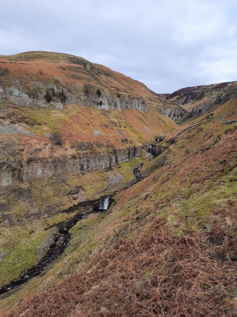
Saturday started with mist hanging fairly low over the hills. I proposed a walk over the highest of the Howgill Fells, starting a few miles down the road at the Cross Keys pub, while others chose slightly shorter routes directly from the hut. Vivienne, Sheena and Claire opted to join me. We started off by ascending towards and past the impressive waterfall of Cautley Spout, then continued into the cloud along the top of Cautley Crag to reach Great Dummacks, where we could tell we were not far below the top of the cloud. Pleasingly, the slight further rise to Calders was just enough to break out of the cloud and gain dramatic views over Arant Haw and the Lune Valley.

Heading towards Cautley Spout
The upper cascades of Cautley Spout
Cautley Crag, with cloud on Great Dummacks
Mist and blue skies over Arant Haw
Looking northwest from Calders

Our high point for the day, The Calf, was not quite clear, but before we’d descended far towards Hare Shaw and Bowderdale Head, we were back below the cloud and the skies were getting increasingly blue. A steep climb up sheep paths brought us to the saddle just south of Yarlside, where we happened to meet Mick’s group completing the ascent from the other side. After a short chat, they continued up, while we paused for first lunch with a lovely view east over Wandale Hill.

Vivienne, Claire and Sheena in Bowderdale

We continued over Yarlside, then dropped steeply down its north-eastern slopes to follow the ridge over Kensgriff and Randygill Top, then more gently along to the trig point on Green Bell, one of just nine Simms outside Scotland that I had not previously visited. We chatted with a group of four from Yorkshire and Cheshire for a few minutes, then had second lunch. Two others came and went as we ate, and a farmer passed nearby on his quadbike – unexpectedly the busiest spot of the day!

Heading off the side of Yarlside
Descending steeply, with a view of Wandale Hill

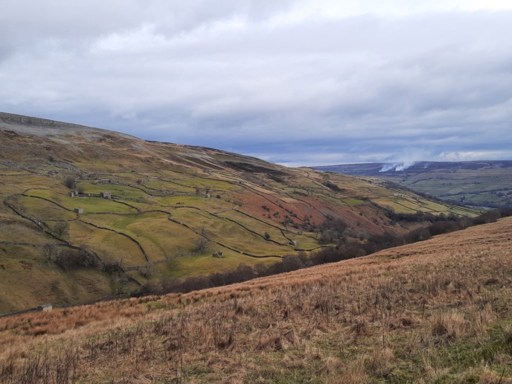
The grassy slopes south of Spengill Head gave an easy descent, followed by a slightly boggier re-ascent to Wandale Hill, another new Hump for me to bag, and an excellent viewpoint over the Yorkshire Dales and Howgills. That just left a descent of the ridge to Narthwaite and a short walk along the bridleway back to the Cross Keys. A lovely day out on the hills, mostly sunny after the initial misty ascent.
Route map: https://www.plotaroute.com/route/3133893

Descending from Spengill Head
Looking over Murthwaite to Wild Boar Fell

Back at the hut, we refreshed with tea and hot showers, and caught up with the other groups. Later we enjoyed an evening meal of soup brought by Jane, chicken filo pie cooked by Claire, and (shop-bought) apple pie from me.

Sunday started sunny, with a cloud inversion visible down the valley over Sedbergh. Sheena and Claire once again opted to join my proposed route, a circuit of Wild Boar Fell and Swarth Fell. I had visited those hills only once before, by chance also in autumn inversion conditions, with Ruth in 2011! We parked on the Fell End road and ascended easily through the pretty limestone pavements of Stennerskeugh Clouds,

Stennerskeugh Clouds
Inversion and the North Pennines

Above there, the going was more tussocky as we crossed over Hushy Gill to gain the Pennine Bridleway where it crosses Scandal Beck. A good track led up to the ridge at the quirkily-named High Dolphinsty. There we gained spectacular views over the Howgill Fells to the Lake District, over the Eden Valley (with cloud inversion) to the North Pennines, over Mallerstang Common to Mallerstang Edge, and along the eastern crags of Wild Boar Fell. Most of the major peaks of the Lakes, Dales and North Pennines were clearly visible. Climbing a little higher, a prominent buttress on High Nab made a great foreground for photos!

Looking over the Howgill Fells to the Lake District (including the Coniston Fells, Scafell massif, Great Gable, Pillar, Helvellyn, High Street, Skiddaw and Blencathra!)
Looking towards Garsdale Head
Looking towards Mallerstang Edge

Further on, we reached a cluster of tall cairns at the East Top, and paused there for first lunch, enjoying the views of Mallerstang and Garsdale Head. We crossed the flat summit plateau to the trig point at the main summit, which was the day’s best vantage point for the inversion in the Sedbergh Valley, with the Howgill Fells beyond. Continuing, an easy grassy path led across the broad saddle to Swarth Fell, again with crags on its eastern side. At the slightly lower summit of Swarth Fell Pike, we left the ridge to drop down rough, tussocky grass over Nettle Brow on intermittent quadbike tracks to the little-used footpath up Grisedale. An old lime kiln was a suitable spot for second lunch.

Inversion, the Howgill Fells and the Lake District
The ridge to Swarth Fell

The next few kilometres were quite rough going on a narrow path through the boggy tussock grass. Clearly not many people complete the long-distance trail of ‘A Pennine Journey’! We paused to look around the smoothed limestone gully of the dry upper reaches of Grisedale Beck, and to look up Rawthey Gill onto adjacent Baugh Fell. Descending gradually into Uldale, we eventually escaped onto a better track at Whin Stone Bridge. From there, it was easy walking along the lanes over Black Moss and Fell End to reach the cars at 4pm. A really memorable day out above the clouds!
Route map: https://www.plotaroute.com/route/3134899

Descending into Uldale
Fell End

Claire and I called in to Natland for a quick chat with Ruth (and baby Chloe) on our way by – my last visit before they move house next week! Roadwords near Carnforth had caused queues on the M6 so we followed Ruth’s recommended diversion through Milnthorpe and Nether Kellet to avoid that without much delay, and were back at my house just before 8pm.

All in all, a fantastic weekend catching up with friends in the sunshine and above the clouds on these quiet but characterful hills. You can find more of my photos on Google Photos here.

A weekend in Kendal (28th-30th March 2025)

I spent a weekend visiting my parents in Kendal, by chance coinciding with Mother’s Day. On Saturday the forecast was for a bright start then a wet afternoon, so a parkrun seemed the ideal activity. We took the short drive to Fell Foot parkrun, at the south end of Windermere, which I had not visited since 2019 despite it being the closest to Kendal. The summer course was in use for the second week this year, and the recent dry and breezy weather had done a good job of eliminating all mud from the grassy path around the meadow. I had a reasonable run, a little under 20 minutes but nearly a minute slower than my previous visit, then joined Dad for his second lap.

Mum and Dad at Fell Foot
Me at the end of lap 1 (photo by Mum)

Once back in Kendal and showered, I spent an hour or so pressure washing the patio. In the afternoon, Mum and I enjoyed a game of Scrabble, then I walked down to town in the rain for a chat wiht the Patricks over a cup of tea – good to catch up for the first time since Ruth’s wedding nearly a year earlier.

Sunday was a sunny day, although quite breezy in the morning. We took a half hour drive to Dentdale for a scenic walk from Dent village. We started with a short but steep ascent on the bridleway beside Flinter Gill, lined with attractive old trees and with sporadic views of the unusual slabby stream-bed (but with very little water flowing down that day!).

The tree-lined bridleway
The slabby river-bed of Flinter Gill

Near the top we passed an unexpected viewpoint with a topograph identifying the surrounding peaks, including the Howgill Fells to the northwest, Aye Gill Pike across the valley and Great Knoutberry Hill to the east.

The view towards the Howgill Fells

A little higher, we reached Green Lane, a traversing track, which we followed to the east, boggy in places, for around a mile. Whernside gradually came into view ahead as we rounded the hillside. We paused for a lunch break below the eponymous Great Combe of Great Coum, then descended by another bridleway, Nun House Outrake. Then it was easy walking along the lane to Double Croft. There we were surprised to find the bridleway down to the riverside flooded, so instead of joining the Dales Way we followed parallel footpaths beside a smaller beck back to Dent. A lovely day out in the sunshine!

Calf Top, to the west
Heading towards Whernside
Descending into Dentdale

We returned to Kendal for the rest of the day, and I headed back home to Derby after roast pork for dinner. You can find more photos here, and a map of our Dentdale route here.

Gentian Yorkshire Dales Trip (1st-3rd December 2023)

The final Gentian weekend trip of the year was to Wharfedale, staying at the cosy Skirfare Barn near Kilnsey Crag. As I often do, I decided to head up a day early and get an extra day’s walking, so I drove up to my parents’ house in Kendal on Thursday evening. After breakfast together on Friday, it was only a 45 minute drive via Sedbergh to the village of Hardraw, at the head of Wensleydale. It had been a cold night, but luckily all the roads had been well gritted.

My motivation for choosing this location for my walk was that an obscure nearby summit, Sails, has recently(ish) superseded adjacent Little Fell as a Nuttall, having been found to be marginally higher. Not having passed over Sails on my previous visit to Little Fell, I needed to return to re-complete the list. I think this was the fourth time I’ve had to re-complete the Nuttalls since my original completion on Mynydd Mawr!

My route was a clockwise circuit of Cotterdale, mostly under a very thin layer of snow. The initial climb up to Cotter End gave excellent sunny views over Wensleydale. Then came a more gradual ascent of the ridge, mostly on ATV tracks but rough and pathless in places, eventually reaching Sails with its small cairn. There were great views towards Wild Boar Fell, to the west.

Widdale Fell, from below Cotter End
Swarth Fell and Wild Boar Fell, from Sails

I continued over Little Fell, then down and back up to the next Nuttall up the ridge, Hugh Seat, which has a more substantial cairn. Surprisingly, I was following a set of fresh footprints for this section of the walk! Then I turned back to the southeast to cross rougher ground, with no footprints, to the day’s high-point, Great Shunner Fell. I chatted with two men at the summit shelter as we ate our lunches and waited patiently for the mist to break up to reveal the views properly – which it duly did. Ingleborough, Whernside and Gragareth were prominent to the south, with Wild Boar Fell still dominating the view to the west.

Looking towards Ingleborough and Whernside, from Hugh Seat
The summit of Great Shunner Fell

The final few miles back to Hardraw were quick and easy, gently downhill on the well-surfaced Pennine Way, with great views across Wensleydale.
Route map: https://www.plotaroute.com/route/2455505

An icy sink hole and tarn
Heading down in to Wensleydale

Then I had a 40 minute drive over the Bardale Head road – 589m above sea level but also gritted and free of ice – to reach Langstrothdale and Wharfedale, arriving at the bunkhouse at around 3:50pm – perfect timing as that was just 10 minutes before we could check in! The evening was spent over dinner, wine and discussion as usual. I had accepted Debbie’s offer to share her tasty vegetarian Moroccan dish.

It was a very cold start on Saturday morning, the car thermometer reading -8 degrees as Sheena and I drove up to Kettlewell to start our walk. Our first objective was Great Whernside. We ascended along Dowber Gill and looked down the entrance to Providence Pot, then zigzagged back up to the left to reach Hag Dyke, a scout centre. It was good to escape the shade of the valley and feel the warmth of the sunshine on the open slopes above!

Looking down Dowber Gill into sunny Wharfedale

Another kilometre of steady climbing brought us to the summit, with its attractive rocky outcrops and trig point, looking particularly good in the snow. Pen-y-ghent and Ingleborough were visible to the west, and Pendle Hill in the distance to the southwest.

Looking towards Pendle Hill (right of centre)
Sheena at the summit of Great Whernside, with Buckden Pike in the distance

Northwards lay our route ahead to Buckden Pike. We followed the flat ridge to Nidd Head then descended fairly steeply down to the road at the col, taking care over a few slippery sections. From there, the re-ascent to Buckden Pike was fairly gentle and straightforward, the boggy sections being easy thanks to being well frozen. We paused briefly to look at the Polish War Memorial, commemorating the death of five airmen, before continuing to the summit trig point and cairn.

On the ridge of Great Whernside
Fountains Fell, Pen-y-ghent and Ingleborough, from the summit of Buckden Pike

Although we were ready for lunch, we decided it was too cold in the breeze near the top, and instead dropped down a bit on the permissive path into the head of Buckden Beck, where we found somewhere warmer and more sheltered. Then we had a quick look at the remains of Buckden Lead Mine before picking up the easy-angled footpath descending south to Starbotton. That just left a few kilometres along the valley to Kettlewell and the car.
Route map: https://www.plotaroute.com/route/2456211

Looking into Langstrothdale
Approaching Starbotton

For the evening meal, we enjoyed hearty servings of red pepper soup, followed by Julia’s excellent pork and cider casserole (for the meat-eaters), and Mike’s delicious apple strudel for dessert. After a good walk and large meal, by 10:30pm most of us were ready to turn in for bed.

A little bit of fresh snow fell overnight, so I was glad that I had decided to leave the car in a nearby layby rather than in the bunkhouse car park at the bottom of a steep slope. We had breakfast, packed up our stuff and cleaned/tidied the barn, then set off on our respective outings. Ted led a few up Buckden Pike (which I didn’t fancy having been there the previous day) while Debbie led a tea-shop walk from Grassington (too low and short to interest me!), so I went for a solo walk from Arncliffe onto the limestone plateau to the south.

Again, the road had been well gritted and was straightforward to drive. Sadly the cloud was very low, so it only took a few minutes walking up the “Monk’s Road” path before I lost any views. I continued south as far as Middle House, where the cloud did lift a bit to reveal some attractive knolls and limestone crags.

Limestone crags on ‘Height’

I looped south to pick up the bridleway along the upper section of Gordale Beck and climb back up towards Lee Gate High Mark. From that saddle, I made two bagging detours, firstly west to Parson’s Pulpit (HuMP and Dewey), and secondly east to Proctor High Mark (another Dewey). Neither gave views, thanks to the thick mist, but it gave me some clear objectives for the day.

Lee Gate High Mark

Back at the saddle, I ate my lunch before following the bridleway north, gently down to Arncliffe Cote. I took a short detour to get a closer look at some very impressive icicles where Cote Gill tumbles down a small crag. Once back in the valley, it was just a couple of kilometres along the riverside back to Arncliffe village.
Route map: https://www.plotaroute.com/route/2456784

Icicles on Cote Gill
The River Skirfare, near Arncliffe

Although unpleasantly sleety much of the way and fairly busy with traffic, my drive home went pretty well, taking a little over 2h30 via Bradford, to arrive soon after 5pm. Although I had walked solo two days and only with Sheena the other, it was good to catch up with everyone at the bunkhouse and enjoy the communal meals together as usual. Three good dry days on the hill, giving a great first taste of winter for this year! I look forward to the Welsh Winter meet in January.

My full photo album can be viewed here.

Birker Fell and Swaledale (3rd-5th March 2023)

Unusually, we both had empty diaries, so I took the opportunity to visit my sister for the weekend. As she wanted to avoid damaging a sore knee, Ruth didn’t want to do long walks, so there was plenty of time for me to fit in a tourist parkrun to start Saturday. The chosen location was Barrow, which was about 45 minutes’ drive from Ruth’s house. Walking into the park at around 8:45, it seemed surprisingly deserted and we began to wonder whether I had somehow missed a cancellation notice, but sure enough a few volunteers were lurking in the bandstand and other runners soon began to emerge. The park is near the town centre, so I suspect a lot of the runners come on foot and don’t feel the need to leave much slack time in their travel plans!

In the end, there were 131 participants. Buoyed by my first sub-20 run for months, two weeks ago on the flat tarmac of Alvaston, I was feeling optimistic for a good time, but doubted I’d be able to achieve that milestone again when I saw the significant hill from lake to war memorial, to be tackled three times. I pushed hard though, and was pleasantly surprised to keep my average pace below 4:00/km throughout and finish in 19:47, just 2 seconds slower than at Alvaston. Four speedy under-16s beat me, two of them in under 17 minutes! Ruth walked around and photographed me at a few locations around the compact course!

Lap 1 at Barrow parkrun, surprisingly already running alone!

Afterwards, we headed north to park at the summit of the Ulpha / Birker Fell road. I had only visited these quiet hills around Devoke Water once before, so it was good to renew my acquaintance. We made an anticlockwise loop around the lake, taking in the rocky summits of Rough Crag, Water Crag, White Pike and Yoadcastle, and enjoying the distant views of the Scafell massif to the northeast, as well as towards the coast.

Looking over Devoke Water into the Lake District
The summit of White Pike, with Yoadcastle in the background

The continuation over Hesk Fell, down to the pass (with a pause for lunch), and back up the other side to Great Worm Crag, was grassier and less steep, From there, it got more interesting again, and it was good to revisit the Wainwright, Green Crag, with its impressive summit tor. Three other pairs of walkers there were the only others we passed all day. Then it was just a short walk back to Birkerthwaite and the car.

Looking past Harter Fell to the Scafell range, from Green Crag
Setting off down from Green Crag

Once we were back in Natland, Ruth had some marking to do, so I gave her some peace and quiet and popped into Kendal to call on Ian and Emma. Great to catch up over a cup of tea, initially with Ian, then joined by Emma and the girls once they returned from a 4th birthday party.

On Sunday we decided to head to the Yorkshire Dales: in particular, to Swaledale, where Ruth had a couple of unbagged Nuttalls. Looking back, I find that I’ve only made one previous visit to that valley myself, on a CUHWC weekend trip 12 years ago to the day! The drive up, via Kirkby Stephen, took around an hour. We parked in a layby just outside the small village of Muker. Once booted up, we headed north up Swaledale and then steeply up the rocky gorge of Swinner Gill – definitely the highlight of the day.

Swaledale, above Muker
Swinner Gill

Once we’d gained the plateau, it was easy walking along tracks to Rogan’s Seat and then on a small path beside the fence to Water Crag, where we had lunch in the large and effective shelter cairn. The moorland views were extensive, north into the North Pennines and south over Swaledale. The terrain was pretty featureless and it didn’t look like the pathless valley from Wham Bottom would give easy walking, so we took a bearing SSE to the end of the bridleway at Blakethwaite, passing over fairly rough heather but surprisingly dry bogs.

Blakethwaite

The tracks down beside Gunnerside Gill gave more attractive walking, with natural limestone crags and various industrial remains from the once-extensive lead mining. There was a lot of lurid green grass and moss in the abandoned mining rakes, presumably affected by the minerals in the soil.

Industrial heritage by the old Blakethwaite Smelter
Fields and barns below Winterings Edge

The final stretch from Ivelet beside the river back to Muker gave an easy grassy finish to the day. We took the 500m detour north to the footbridge once we had confirmed that there was no easy crossing available on the direct path. I paused at Ruth’s for dinner before hitting the road for a quiet and undelayed drive back home. Great to revisit two quiet but pretty areas that I had only been to once before. And less than a week until my next trip to the Lake District!

Maps of our routes are available here (Birker Fell) and here (Rogan’s Seat), and more photographs here.

Bentham visit (28th-30th October 2022)

My parents are in the process of moving from Somerset to South Cumbria, and are currently renting in Bentham, near the border of North Yorkshire and Lancashire, while they house hunt! I visited them for the weekend to catch up and see their rented house. With major delays due to accidents on both the M6 and M1 on Friday afternoon, I knew it was going to be a slow drive north after work. I left at 3pm and plumped for the M1 option. It may or may not have been the best choice, but it was certainly slow, taking around 4 hours to reach my destination. It was good to be there in time for a late dinner and evening chat though.

With rain forecast for most of Saturday, it wasn’t going to be a proper walking day, so we decided we might as well start the day with a parkrun. The nearest one I hadn’t done before was Morecambe Prom. Dad and I ran – there and back along the promenade – while mum spectated. I was glad that my knee, which has been sore lately, didn’t twinge significantly or hamper my running, and was therefore fairly happy with my time of 20:06.

We returned to Bentham for morning coffee and a leisurely lunch. By mid afternoon, it was brightening up, so we headed out for a short walk from home, up the lane and a short distance across the moor to a local landmark, the ‘Big Stone’, or more formally the Great Stone of Fourstones. This is a glacial erratic, and certainly seems out of place on the edge of the moors of the Forest of Bowland. It is not known what became of the other three stones! We had salmon for dinner and a standard evening in front of the television.

The view from atop the Bentham ‘Big Stone’
Dad and Mum by the Big Stone

Sunday’s forecast was a bit more promising – still grey, but dry for the morning at least. We therefore chose to use our extra hour (with the clocks going back) not for a lie-in but to give more dry walking hours, and were underway in nearby Clapham before 9am. We started by followed the bridleway above the forest to Clapdale Farm, then dropped down into the valley near Ingleborough Cave. From there, it was only a short distance up to the impressive gorge of Trow Gill – very different from my one previous visit in snow!

Heading up Trow Gill

Once we’d clambered up to the top, it was easier walking across the moor to Gaping Gill, where the river plunges underground (to later emerge at Ingleborough Cave). A dramatic spot, although the river was not flowing as strongly as I’d expected.

Gaping Gill
Dad and Mum above Gaping Gill

We returned by the paths over Clapham Bottoms and then track down the east side of Clapdale. A few spots of rain fell as we neared the village, but weren’t sufficient to merit waterproofs, and the proper rain held off just long enough for us to have lunch outdoors on a picnic bench before the return to Bentham.

On the track below Thwaite

We had a leisurely afternoon at home. Ruth and Josh came around to join us for roast dinner, after which I returned to Derby, thankfully not meeting any delays on the M6 route and getting home in a much more civilised 2h15!

There are a more photos here, and maps of our walking routes here (to the Big Stone) and here (to Gaping Gill).

Christmas in Natland (19th-27th December 2020)

Ruth and I had hoped to spend the Christmas travel window in the southern Highlands but our plans were thwarted by the last minute reduction of that window to a single day and total closure of the Scottish border to non-essential travel. Instead, we therefore spent the week at her house in Natland and entertained ourselves with a selection of local walks and runs.

Sunday was wet and windy so we opted for a local trail run rather than a trip into the high fells. We started in Kendal and ran together up onto Cunswick Scar and then south along the ridge over Scout Scar. Ruth dropped back down to Kendal for a 10k loop while I continued south past Sizergh Castle and then through Levens Park and back up the old canal to Natland, around 20k in total. The strong southerly breeze made it hard work with a headwind much of the way, but thankfully the rain held off save a couple of showers towards the end. At the end of week 2 of my 16-week marathon training plan, it was good to get the long run ticked off in such scenic surrounds.

On Monday we headed to Patterdale for our walk, with the best of the weather forecast in the northeast Lakes. We parked by the George Starkey Hut and set off across the valley to Side Farm, surprised to find that Ullswater had flooded this far up the valley and had to splash through up to six inches of water on the track. I was surprised to get across with dry feet! We then followed the scenic traverse path parallel to the lake shore, over Silver Crag and on to Martindale where we paused for lunch. Although the forecast had been for improving conditions, the cloud had gradually dropped through the morning, and our return route over the top of Place Fell was mostly in thick and damp mist, with few views until we dropped back out of it at Boredale Hause for the short descent back to Patterdale.

The flooded track to Side Farm
Looking back along Ullswater towards Patterdale
Dropping down into Boredale

Tuesday was a drier and brighter day. We started at the head of Langdale, where Andrena joined us for our ridge walk over Pike o’Blisco, Crinkle Crags and Bow Fell. The ascent of Pike o’Blisco was mostly in sunshine, with excellent views of the Langdale Pikes and down the valley towards Fairfield. After passing Red Tarn, we walked in mist for some of the ascent to Crinkle Crags, but were rewarded at the summit where we broke out of the top of the cloud for a few minutes and enjoyed some impressive cloudscapes. The clouds gradually lifted again as we continued past Three Tarns and up Bow Fell, such that we had intermittent views west to Scafell Pike and northeast towards Helvellyn. Bow Fell is surely one of the finest viewpoints in the Lake District, and the air clarity this day (when outside the cloud!) was superb. We descended via the Band to reach the car just before sunset.

Langdale, with Helvellyn (in cloud) and Fairfield in the distance
Looking over Browney Gill to the Langdale Pikes
Inversion south of Crinkle Crags

It was wet and windy again on Wednesday, so we didn’t go out together. I made the most of a pause in the rain for an interval training session on the flat and almost deserted lanes of the Lyth Valley. The upwind intervals heading northeast were much slower than the downwind ones to the southwest!

Christmas Eve was forecast to have the best weather of the week and so it proved for our walk around the Coledale Horseshoe. We parked in Braithwaite and chose to walk clockwise, starting with the ascent of Barrow. Snow had fallen the previous day to leave a clear snow-line at around 600m, and the ground was frozen hard at all levels. We first reached the snow on Causey Pike, and walked mostly on the white stuff from there all the way around to Grisedale Pike. Once again, the visibility was superb and we enjoyed views of the snowy, sunlit summits of the Northern Fells and the Helvellyn ridge as we continued over Scar Crags to Crag Hill, as well as towards Scafell Pike and High Stile.

Skiddaw and Blencathra, from the summit of Causey Pike
Crag Hill, from Sail
Ruth on Crag Hill, with Helvellyn in the distance

The snow had drifted fairly deeply on the west side of Crag Hill, making for an enjoyable descent before the climb back up Grasmoor, whose northern crags looked grand today. Hopegill Head also gave fine views, east over Grisedale Pike to Skiddaw, south over Coledale Hause, and north over the Solway Firth to Criffel – as clear as I’ve ever seen it! The descent from Grisedale Pike brought us quickly back below the snow-line and onto frozen turf all the way back to Braithwaite. It was unusual to walk all day in the Lakes with no sign of a thaw at any level! Despite the sunshine, it had been bitterly cold in the north wind, and we had not wanted to take our gloves off for more than a moment at any point!

Looking over Whiteless Pike towards Scafell Pike and High Stile
The view from Grasmoor towards Skiddaw
Crag Hill, from Sand Hill
Ruth at the summit of Hopegill Head

We were keen to get out for a walk on Christmas Day, and chose to head to the Yorkshire Dales where we could get up and down Ingleborough before lunch, leaving plenty of time for preparing the Christmas dinner afterwards. The morning started with hazy sunshine that gradually turned to high level cloud as we ascended by the good track from Ingleton – a popular choice as we must have passed around 50 people in total. Having taken in the views from various points around the summit plateau, we descended towards Little Ingleborough and from there took the boggy path (hard frozen again today!) back to the lane and Ingleton.

Heading past Crina Bottom towards Ingleborough

We had a lazier start on Boxing Day with more rain expected in the hills. I jogged into Kendal mid-morning to have a go at the MapRun orienteering course around the town centre before jogging back to Natland for a relaxed afternoon and dinner of Christmas leftovers.

My full photo album is available on Google Photos here: https://photos.app.goo.gl/zEmyi9MnGYM1MrGEA

Maps of our walking routes can be seen here:
Place Fell: https://www.plotaroute.com/route/1381568
Pike o’Blisco to Bow Fell: https://www.plotaroute.com/route/1381571
Coledale Horseshoe: https://www.plotaroute.com/route/1381576
Ingleborough: https://www.plotaroute.com/route/1381577

All in all, a lovely relaxing week in some familiar but very scenic places – a pretty good consolation prize to ease the disappointment at not being able to make a trip to the Highlands this winter!

Yorkshire Dales (24th-26th August 2019)

As I was taking part in another Mini Mountain Marathon in the Lake District on the Sunday, I spent August Bank Holiday weekend in the northwest of England. Having broken the drive up with a dash around Preston parkrun – in an attractive park beside the Ribble – I met up with Ian and Emma (and Ellen) mid-morning and we chose to head to the Howgill Fells for a walk away from the crowds. Starting in Sedbergh, we ascended by Settlebeck Gill to Arant Haw and Calders, returning via Winder, and enjoyed sunshine and very clear views over the Dales to the Three Peaks. Then it was back to Kendal for dinner and chat.

Descending from Calders

On Sunday I took part in the King Mini Mountain Marathon, a four-hour score event, starting in Loweswater and heading up onto the Grasmoor fells. Tough going on a hot sunny day, but great scenery and a great challenge. No time for photos though!

On Monday I was tempted back into the Yorkshire Dales by MWIS’s suggestion that higher summits may be above the cloud. I opted for a round of the Gragareth group from Ireby. Unfortunately these hills proved not to be quite high enough, and I was in damp mist most of the way! On Great Coum, I could see a hint of blue sky above, but still didn’t emerge from the cloud. I descended via Bull Pot Farm and then along the scenic Ease Gill.

The track to Bull Pot Farm

My full photo album is available on Google Photos here: https://photos.app.goo.gl/HfnpJvdgHtd41U6h7

Band trip to the Yorkshire Dales (5th-7th October 2018)

The third biannual Rolls-Royce Band hillwalking weekend went to the Yorkshire Dales to tackle the Three Peaks Challenge. Plus photos of my solo Friday walk on Kirkby Fell, and a few survivors’ Sunday-morning walk around Gordale Scar and Malham Cove!

https://photos.app.goo.gl/zBfiX33vzM5oVES27

The group below Pen-y-ghent: Andrew, Heather, Grahame, Heather, Jeff, Helen, Jo, Pete, Ian and Ben

Wharfedale, Northumberland and Weardale (6th-8th February 2015)

A varied and mostly sunny long weekend based around a visit to Ian and Emma in Chester-le-Street. I broke the drive north on the Friday by bagging Yockenthwaite Moor, in Wharfedale. On the Saturday we pottered around Bamburgh on the Northumberland Coast. And on the Sunday I ticked off three more Nuttalls south of Weardale.

https://photos.app.goo.gl/DiwDTTUnmqBKwEpj9

Sunshine in the fields above the hamlet of Cray

Ian and Emma’s Stag/Hen weekend (28th-30th June 2013)

I went up to eastern Cumbria for Ian and Emma’s joint Stag/Hen weekend, staying at Bents Camping Barn near Kirkby Stephen. Among other activities including canoeing on Ullswater and a pub dinner in Ravenstonedale (of which no photos), we did two short walks in the nearby limestone fells, fortuitously including two HuMPs!

https://photos.app.goo.gl/DZm5NaYytvwvZZJo7

The group above Bents Camping Barn