Rolls-Royce Derby Band’s fourth annual (not)Butlins social weekend went to Priestcliffe, in the heart of the Peak District, organised this year by Tim and Janice. Heavy snow had fallen on the Thursday night, with around five inches on the ground in the High Peak, so we were a little apprehensive about the road conditions for the drive up. However, all the gritted routes had been well cleared by Friday afternoon and the farmer had helpfully ploughed the one mile of lane from the A6 into Priestcliffe, so the journey was straightforward (except for Will and Jane, who inadvertently and unsuccessfully attempted one of the smaller lanes into the village!).
Our accommodation was the luxurious ‘Broadway Barn’, a very smart barn conversion sleeping twelve in six bedrooms. Jeff and Helen prepared baked potatoes for dinner and the rest of the evening was spent chatting over a few drinks.
Bedroom window views
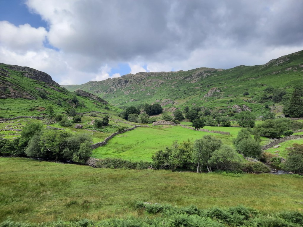
Predictably, both the nearby parkruns were cancelled, so I led our own improvised 5K run from Priestcliffe in the morning instead. Jeff, Helen, Will, Jane and Tim joined me on the perfect crunchy snow with enough give in it for the shoes to grip well but enough firmness not to be hard work or get wet feet. We followed a track and footpath down into Miller’s Dale, turned west up the Monsal Trail for a while, then picked up another footpath back to the barn. A perfect morning with the beautiful snow all around and clear blue skies overhead. We enjoyed coffee and bacon sandwiches for second breakfast to warm up on our return. The others had popped out to the farm shop at Chatsworth for their breakfast.
Sunrise over High DaleLooking back to PriestcliffeJane, Will, Helen, Jeff and Tim on the Monsal TrailJane and Jeff approaching Priestcliffe
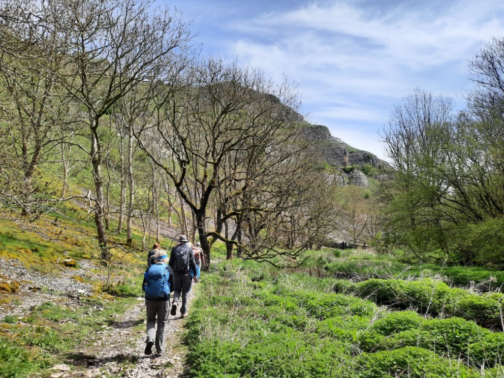
In the early afternoon, we set off in three groups to the Angler’s Rest in Miller’s Dale. I led an 8km route with Jeff, Will and Tim via Blackwell and Chee Dale with its famous stepping stones along the bottom of the cliffs in the narrowest section of the gorge. The stepping stones were, thankfully, not icy, but the same could not be said for some of the other sections of path traversing on sloping ledges above the river – great care required and luckily none of us fell in!
Jeff and Tim traversing an icy path above Wye DaleJeff, Tim and Will on the stepping stonesChee Dale
Another group walked down by a more direct route, while some others drove. We gathered for a drink in the cosy hikers’ bar, then the long-walk group walked the 2km back up the hill to Priestcliffe just before dark. Route map: https://www.plotaroute.com/route/3200432 Jeff and Helen cooked lamb burgers and jam sponge for our delicious dinner, accompanied by a few more drinks and some games and more chat in the evening.
Sunset on the walk back to Priestcliffe
Sunday was a wet day, so there was no temptation to head out for another walk. We had a leisurely start, cleaned and tidied the barn, packed our bags and were on the road by 10am, the remaining ice on the road now mostly turning to slush. We headed to the café at the Pavilion Gardens in Buxton for morning coffee and cake, then went our separate ways.
Back in Hilton, the snow (only ever about two inches) had almost entirely melted and I felt virtuous after running a half marathon around the local lanes in the late-afternoon once the rain had stopped! A good end to an excellent weekend with friends in a lovely part of the county!
I headed to Kendal and Hale for four days with family for Christmas, driving up after work on Tuesday 23rd to my parents’ house for the night. On the morning of Christmas Eve, Mum and I met up with Ruth and Chloe for a sunny stroll up Hampsfell, a Wainwright Outlying Fell above Grange. The low sunshine over Morecambe Bay at low tide was quite spectacular, as were the distant views of the Lake District and Howgill Fells. Route map: https://www.plotaroute.com/route/3190808 After dinner at Mum and Dad’s I relocated to Ruth and Josh’s house for the night.
Looking towards the Coniston FellsMum, Ruth and Chloe at the summit of HampsfellAfternoon sunshine over Morecambe Bay
As has become traditional for me, I started Christmas Day with a parkrun, this year returning to Ford Park in Ulverston, three years after my previous visit. Thanks to a much-improved path surface around the bottom part of the park, the course was faster than last time, and would have been better done in road shoes! 201 runners was a record attendance for Ford parkrun. Afterwards, I headed straight back to Hale, arriving just a few minutes after my parents. We exchanged presents and had Christmas dinner together, then all took an afternoon stroll through the nearby woodland including a visit to some local pigs. Route map: https://www.plotaroute.com/route/3190812
Me at Ford parkrunAscending through the woods above HaleRuth and the pigs
On Boxing Day, I started the day with another run, accompanying Ruth, Josh and (in the buggy) Chloe for a loop through Dallam Deer Park and Milnthorpe. After lunch, Mum, Ruth, Josh (carrying Chloe) and I went for a stroll up Farleton Fell, just across the valley from Hale. It’s always a lovely spot with the extensive limestone pavement and views of the Lake District and Yorkshire Dales. Route map: https://www.plotaroute.com/route/3190821
Josh, Chloe, Ruth and Mum below the crags of Farleton FellLooking towards the Lake DistrictLimestone pavement and the Yorkshire Dales
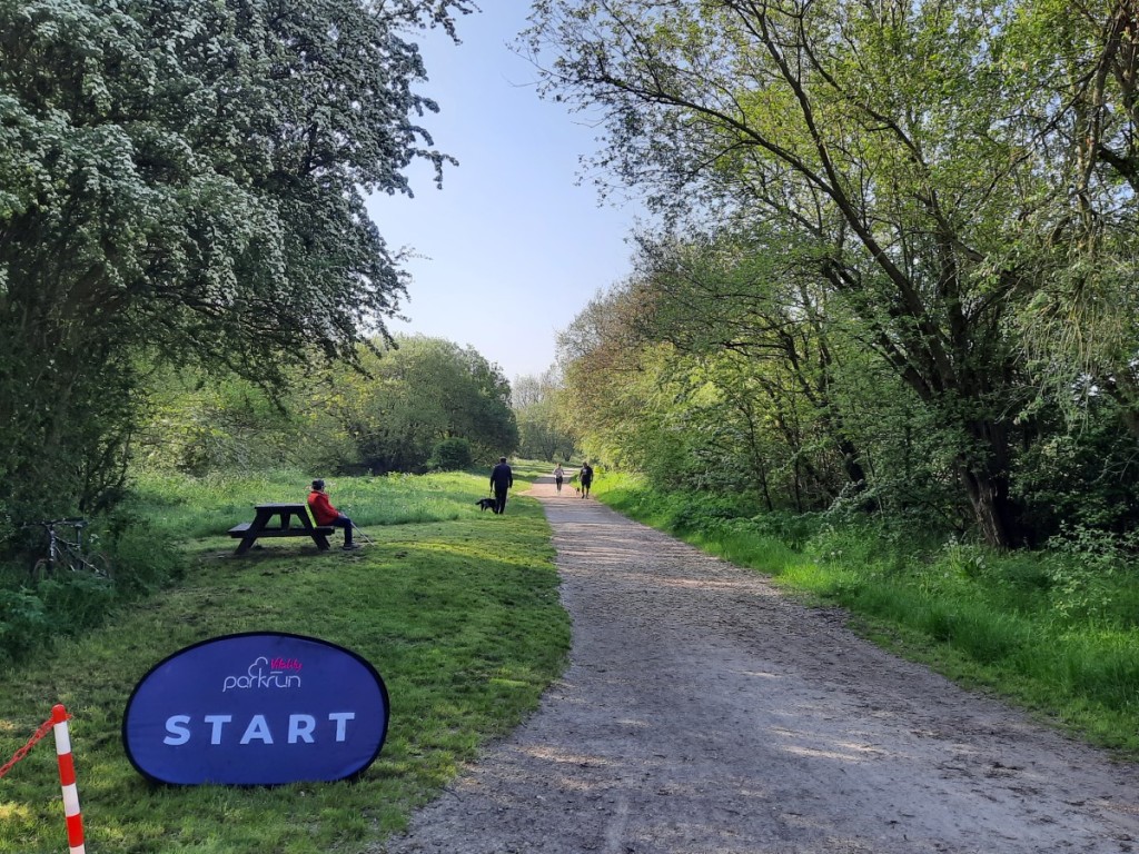
Saturday started, of course, with another parkrun. I had arranged to meet up with Amy and the girls for a walk in Langdale afterwards, so the most convenient choice was Rothay Park parkrun in Ambleside. There was lovely dawn sunshine on Fairfield and Loughrigg. Thanks to a heavy frost, the start on grass was not at all muddy and, thanks to water works, the previously muddy section around Miller Field has been replaced by an out-and-back on gravel, so once again I wished I had worn road shoes! Nevertheless I had a good run and was pleased to be first finisher – my 10th time, all in different locations.
Rothay Park
After the run it was only a 15 minute drive to the Stickle Ghyll car park, where I just had time to get changed into walking gear in the back of the car before Amy, Isla and Lily arrived. We were lucky to have clear blue skies and light winds for our very scenic walk over the Langdale Pikes, taking in five Wainwrights: Loft Crag, Pike of Stickle, Harrison Stickle, Thunacar Knott and Pavey Ark. The paths and rock were generally dry and grippy but there was a lot of water-ice in the streams, tarns and puddles, which the girls were excited to see. It was good to see that Isla was much more confident near steep edges than she had been on our last walk (up Black Combe in August), and even managed the short scrambly sections without hesitation. Lily was also enthusiastic about the scrambling, as expected! It was good to catch up with Amy as we walked. It’s surprising how long a walk takes with two under-10s faffing, and we got back to the car just before dark. Route map: https://www.plotaroute.com/route/3190828
LangdaleCrinkle Crags and Bow FellLily, Amy and Isla below Pike of StickleIsla and Lily on Pike of StickleLangdale and Windermere from Harrison StickleLily, Isla and Amy on Pavey Ark
I returned to Kendal for dinner with my parents, and was well placed for my journey to the Highlands the next day. To be continued… You can find my full photo album here.
I took a weekend trip to the southern edge of Cumbria to visit Ruth, Josh and (now five-month-old) Chloe in their grand new house in Hale. As I’d attended the RR Harriers Awards Night on Friday evening, it was a Saturday morning drive north this time. That gave the opportunity to visit a new parkrun, extending my line of visited events close to the M6 with a small detour into Warrington, 70 minutes from home. A band of rain had been passing over from early morning but conveniently subsided to nothing by the time I was doing my warm-up. The course comprised a 1km loop within Victoria Park, followed by an out-and-back through Black Bear park with a short loop across some playing fields and beside the Manchester Ship Canal at the far end. Flat and fast, but nothing very scenic or memorable on this very grey morning! I finished third in a time of 19:08.
Me at Warrington parkrun
I was back on the road soon afterwards and arrived at Ruth’s before 11am. After a tour of the house and a coffee, we were off out to the make the most of a dry afternoon. I borrowed one of Josh’s bikes to join Ruth for a linear bike ride along quiet lanes to Newby Bridge. I could definitely tell I hadn’t ridden for over two years, with some shaky bike-handling in the low-speed corners to start with! The route was mostly quite flat, except for one steep climb over Tow Top to raise the heart rate! Don’t think I’ll be adopting cycling as a new hobby anytime soon, but it was a good way to spend some time with Ruth while she got some exercise between baby feeds. Josh and Chloe went by car and were waiting for us with sandwiches for lunch on our arrival. Route map: https://www.plotaroute.com/route/3172504
After a short drive into Grizedale Forest, it was time for the day’s third physical activity: a walk up Carron Crag, a Wainwright Outlying Fell I had not previously visited. We followed a signposted loop on forest tracks and paths. DIsappointingly, no summit view as the cloud was extremely low all day! We all returned to Hale by car and spent the rest of the afternoon and evening in the house. Route map: https://www.plotaroute.com/route/3172501
Josh, Chloe and Ruth at the summit of Carron Crag
Sunday was wetter, and we had a relaxed morning. After lunch, a drier spell allowed us to get out for a short walk to explore some of the local footpaths. The woods west of Hale are, surprisingly, dotted with sections of limestone pavement! We passed through the hamlet of Slack Head then took another path up to the Fairy Steps, a popular local landmark. The footpath squeezes through a narrow crack in the rock to get up/down a small limestone crag. We descended to Beetham then followed more footpaths through the fields back to Hale. Route map: https://www.plotaroute.com/route/3172505
Limestone pavement in Beetham ParkRuth on the Fairy Steps
I headed home after an early roast-chicken dinner, the journey taking an easy 2h01 on quiet roads with no roadworks at present. It was great to see the new Livesey house, to catch up with Ruth and Josh, and to see how much more Chloe is interacting with the world now. There are a few more photos here.
My parents came down to Derbyshire to visit me for the weekend, making the journey by train for the first time. It’s not a bad option, their house only being a few minutes from Oxenholme station, and a single change in Crewe gets them onto my local line for an easy pickup at Tutbury & Hatton, just a few minutes from mine. Nearly as quick as driving, providing the 10-minute connection works out – which it did both ways this time! They arrived around lunchtime on Friday and I worked from home in the afternoon while they took a stroll around Hilton Nature Reserve.
We started Saturday with a visit to Markeaton parkrun, me running and Mum and Dad supporting. James, Gemma and Andy from Rolls-Royce Harriers were all celebrating landmark birthdays and there was a good turnout from the club, as well as a few of my regular parkrun companions from the brass band.
Rolls-Royce Harriers at Markeaton parkrun
We returned home for coffee and a shower, relaxed until lunch, then took a short drive to Calke Park for an afternoon stroll. We parked in the Round Car Park, near Staunton Harold Reservoir, and basically walked the perimeter of the park: along the reservoir shore, around the Deer Park, through the woods, along the Tramway Trail for a bit, then back past the church. Route map: https://www.plotaroute.com/route/3073359
Dad and Mum by Staunton Harold ReservoirA deer in the Deer Park
On Sunday morning, we headed into the Peak District in search of flowering heather, the season having started promptly this year after all the warm weather. Stanton Moor was my chosen spot, and provided us a great display of purple interspersed with yellow gorse, red-tipped bilberry and rich green bracken. We parked in the Birchover car park, and followed the main path via the Cork Stone and trig point to the Nine Ladies Stone Circle. From there, we looped back around the far side of the moor then took a footpath across the fields to Birchover village to pick up an old bridleway back up the ridge to the car. Route map: https://www.plotaroute.com/route/3073364
Dad and Mum among the heather on Stanton MoorBanks of flowering heatherMum and DadNine Ladies Stone Circle
We took a short drive to Winster for a picnic lunch then returned home for a relaxing afternoon, including a game of Scrabble for Mum and me.
We were disappointed, on checking the train status on Monday morning, to find that Mum and Dad’s train from Crewe had been cancelled, which would add an hour and probably some overcrowding to their journey home. Then an hour later, we were relieved and surprised to find that the service had been reinstated! So it was back to Plan A and a slightly late start at work for me enabled me to do the station drop-off without giving them too long a wait for the train to Crewe. The trains were busy but they managed to get seats and were not significantly delayed getting home.
It was great to host Mum and Dad for the weekend again and I was glad their new travel option went to plan, hopefully smoothly enough not to be off-putting for next time!
June’s Gentian Club meet was to the North-western Fells of the Lake District. Due to a mix-up with the hut booking, there had been a late rescheduling of the trip, a week earlier than originally planned – not particularly convenient for me as I had entered and was keen not to miss the Carsington Hill Race on the Friday evening! A good choice as it was a perfect dry and breezy evening for a fell race, and it turned out to be a very enjoyable course with a very steep (walked) ascent from the village to start off, then nice runnable undulations on bridleways and footpaths around the back of Harborough Rocks, and a lovely fast descent on grass to finish. Surprisingly, I was not the only Gentian Club member running – Sue was also there and we had chance to chat briefly before the start and after the finish. I was pleased to finish in 10th place, accruing a useful 27 points for the Rolls-Royce Harriers championship!
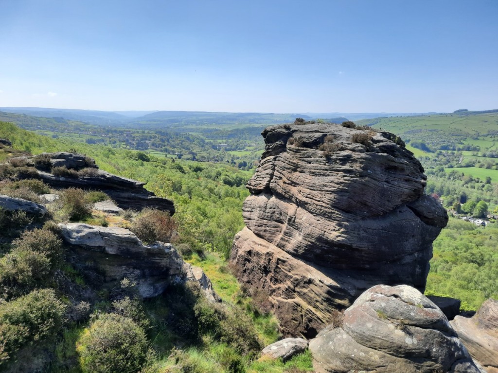
The view from Carsington Pastures (taken on my warm-up!)
Chilli and cake were available in the church after the race, and that was a convenient option for me, avoiding the need for a separate dinner stop on my drive north. To avoid an extremely late arrival in the Newlands Valley, I only drove as far as my parents’ house in Kendal that night, getting there a little before 11pm. Mum kindly stayed up to welcome me, and got up to see me off again the next morning! Another hour’s driving got me to Little Town, from where it was a very slow 10-minute drive up the gravel track to the Carlisle Mountaineering Club hut, near the head of the Newlands Valley. It was my first visit to this hut and it’s a delightfully secluded spot!
The remote and basic Carlisle Mountaineering Club hut
The others were just discussing their routes for the day when I arrived. The fairly wet forecast had convinced them that lower-level walks were the best option but, obviously, I was more optimistic and offered to lead an anticlockwise round of the Newlands Horseshoe. Sheena chose to join me, and Vivienne as far as Hindscarth (but then she wanted to turn the other way to bag Robinson!).
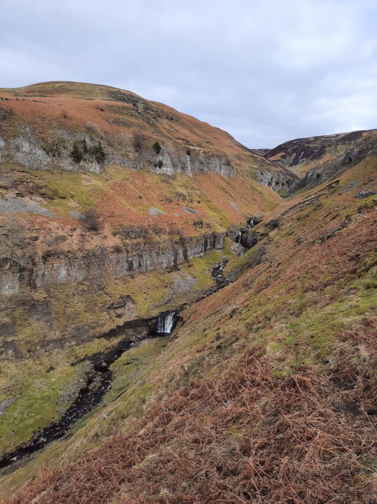
It’s a scenic ascent up the north ridge, clambering up a few easy rocky outcrops to reach the terrace of Scope End, then up steep grass to the summit. After a mostly dry start, a spell of moderate rain did blow in for the second half of the climb, lasting a bit over half an hour and just about petering out by the time we got to the top. There were fleeting views through breaks in the cloud across Buttermere to Haystacks, High Stile and beyond.
Looking back down to the hut from Scope EndLooking down the Newlands Valley from Scope End, as the rain arrivedCloudy views towards High Stile
As planned, Vivienne went her own way at Littledale Edge, and Sheena and I continued up to Dale Head in brightening conditions. We paused at Dale Head Tarn for first lunch, then continued along the ridge over High Spy and Maiden Moor. Keeping to the left hand side gave the best views over the impressive crags.
Sheena at the summit of Dale HeadLooking towards Coledale over the crags of High Spy
Coincidentally, just as we arrived at the saddle between Maiden Moor and Catbells, Howard and Claire also arrived, coming up from the Derwent Water side having been to Castle Crag! We merged groups for the rest of the walk. We didn’t pause long at the summit of Catbells – a great viewpoint but busy as always – but dropped down to Skelgill Bank for a quieter second lunch. Then it was an easy walk walk back up the track to the hut, finishing with dry kit thanks to the sunny spells and fresh breeze. A better day than expected, with just the one heavy shower and plenty of sunshine. Route map: https://www.plotaroute.com/route/3005308
The Newlands and Coledale hillsThe very green Newlands Valley, from Catbells
The evening followed the usual format with plentiful tea, dinner together, then drinks and chat until bed. Steve did a tasty chilli for main course for the meat-eaters, and generously shared around a bottle of port afterwards. The pot-bellied coke stove was very effective at keeping the room warm, but not particularly well sealed and it was smokier than I would have liked.
Sunday’s forecast was better and the day started brightly, so I proposed a round of the Coledale Horseshoe. That would also be very productive for Claire’s Wainwright-bagging! She, Sheena and Vivienne opted to join me. Sadly, the early sunshine had gone by the time we had packed up and left the hut, and we drove in rain down the valley to Braithwaite, parking near the bottom of the Whinlatter Pass.
On-and-off rain, with only short dry interludes, continued for our ascent up the grassy ridge to Barrow, then across the heathery saddle to Outerside, and it was only when we completed the rising traverse back to our left onto Causey Pike that it really felt like it might brighten again. I had forgotten what an excellent viewpoint it is over the Newlands Valley – I think I have gone straight from Scar Crags to Outerside on my last few (anticlockwise) rounds.
Rather wet as we headed up BarrowLooking along Ard Crags and Scar CragsSheena, Claire and Vivienne at the summit of Causey Pike, looking towards misty Skiddaw
Thankfully, after a damp couple of hours, it did stay generally dry from then on. We continued, in and out of mist, over Scar Crags and up the unattractive bulldozed zigzags to Sail, then stopped for lunch in a sheltered spot on the slopes of Crag Hill, with excellent views down Coledale.
Looking back down the zigzags from Sail
The cloud base was hanging persistently around 800m so it didn’t seem worth including Grasmoor this time – we descended by the upper part of Gasgale Gill instead to reach Coledale Hause, followed by the short climb up the scree path to Hopegill Head. It’s a lovely well defined ridge from there to the final peak of the day, Grisedale Pike – which was another one on Vivienne’s wish list – and mostly easy walking on the descent back to Braithwaite. Again, the late sunshine and breeze had dried us out nicely – always good not to have a pile of wet gear to dry on getting home! Route map: https://www.plotaroute.com/route/3005314
Crag Hill over Coledale HauseLooking towards Grisedale Pike, with Blencathra and Clough Head beyondLadyside PikeLooking back from Grisedale Pike – Grasmoor had cleared eventually!
I paused on the way home to join Mum and Dad for roast chicken dinner in Kendal, then had a quiet drive the rest of the way to Derby. A busy weekend squeezing in the fell race as well as the club meet, but definitely worth the effort for two good ridge walks and time spent with friends. You can see my full photo album here.
I’ve established a tradition of visiting my favourite local parkrun, Bestwood Village, to celebrate the milestone whenever I reach a multiple of 50 parkruns. This week was my 200th, and thus my 4th visit to Bestwood! I love the hilly challenge (100m ascent equals or matches anything else in the area), the mixed parkland and woodland scenery, and the fact it’s a genuine single-lap course with no out-and-back or repeated sections. Jeff and Helen, Will and Jane, Jonathan and Andy kindly turned out to celebrate with me.
I’m in pretty good form at the moment so was hopeful of setting a course PB and ran hard from the off. As always, I’m better on the ups than the downs, and I was leading at the top of the first hill, dropped to third place on the descent, regained the lead by the top of the second hill, and dropped back to second soon after that. I was glad of the pacer to drag me along though, and finished about 10s behind him, in 20:05, a full minute ahead of third place. Tantalisingly close to a sub-20 (would have been well within if the course were not 150m over distance, but that’s part of the challenge at Bestwood)!
Will, Jane, Helen, Jeff, me, Andy and Jonathan after parkrun (thanks Will for the photo!)
Afterwards, I decided to make the most of having driven to central Nottinghamshire by having a drive-bag-repeat day, touring around some of the county’s Tumps. Not the most inspiring list but it’s been in the back of my mind as a small local project for a while.
1) First on the list was Ramsdale Hill, near Calverton. This one’s a drive-up, the highest natural ground being within the car park of the Priory mental health hospital. I walked a few metres to a nearby artificial mound in the grounds, then got back in the car!
2) Next up was Loath Hill, north of Oxton, which at least had a rural setting. The highest point is near the trig point and a couple of transmitters, on a field edge above some woodland. Better views were on offer from the adjacent Robin Hood Hill.
The track up Loath Hill
3) I continued north to Redgate Wood, near Eakring, for the next summit. After visiting the trig point and nearby high-point in the woods, I took the time to explore the marked trail around the adjoining Duke’s Wood, where I was surprised to find several restored ‘nodding donkey’ oil pumps. I associate these with childhood walks in Purbeck when visiting my uncle Michael. The information boards advised that this was the UK’s first onshore oil field, established urgently and in great secrecy at the start of World War 2, when German U-boats were very effective at cutting off our previous supplies from the USA and Iran. A number of American oil-men came across to help establish the field, and there’s a also memorial to their efforts on the site. It remained operational until the 60’s.
A nodding donkey in Duke’s WoodMemorial to the US oilmen who helped establish the field
4) I had to drive through the rather congested centre of Newark to reach my next objective, Beacon Hill. The highest natural ground is just outside a fenced reservoir compound, although the embankments inside are obviously higher. I followed the advice of previous visiting baggers and went up through some woodlands on the south side of the hill. It didn’t seem worth exploring further.
5) Starting to head back towards home, the next stop was near East Bridgford for Old Hill, situated above the south-eastern bank of the River Trent. There’s an attractive escarpment here with several spurs and re-entrants, and an undulating bridleway crossing over them leads very close to the summit, with decent views over the river. Unfortunately the only way into the (private) summit field (without coming from the other side and blatantly trespassing in view of houses) is to crawl under/through a prickly hedge – not much fun! As so often with these obscure hills, there was a transmitter near the high point.
Looking over the Trent valley from near Old Hill
6) Continuing southwest to Radcliffe-on-Trent, I reached Dewberry Hill. The western slopes are a nature reserve with a good signposted circular route through it, but nothing particularly memorable to see. Reaching the high-point just required hopping over a fence onto the adjacent golf course. I think I managed not to disrupt any of the golfers’ games!
7) The seventh hill of the day was another very quick one – Wilford Hill is just a short stroll up a bridleway behind Wilford cemetery, with another transmitter at the summit. There were quite a few locals out for a walk.
The summit of Wilford Hill
8) I parked in Barton-in-Fabis for my walk up nearby Brands Hill, another one on the escarpment south of the River Trent. A bridleway leads through the woods below the ridge, but then it’s a very steep clamber up the slopes to reach the summit at the edge of a crop field. The woods unfortunately block any view of the river.
Looking down from Brands Hill to the recently-decommissioned Ratcliffe-on-Soar power station
9) The final stop of the day had the bonus of offering two Tumps that it actually seemed worthwhile to walk between! I parked by the church in Gotham village and followed bridleways onto Gotham Hill then a footpath through the woods to the highest point in the woods. A wide bridleway, gravel and then grass, led directly to the final summit, Court Hill, on the edge of another golf course. A short descent on a bridleway through sheep pastures led me back to Gotham. Route map: https://www.plotaroute.com/route/2997341 (don’t think I’ll bother for the others, which were no more than a couple of kilometres each!).
Gotham from Gotham HillThe track to Court Hill
That’s ten new Tumps bagged in total. Added to the three Nottinghamshire hills I’d already done, that takes me almost half way through the county’s 27 in total! If you’re really keen, there are a few more photos here!
I spent a weekend visiting my parents in Kendal, by chance coinciding with Mother’s Day. On Saturday the forecast was for a bright start then a wet afternoon, so a parkrun seemed the ideal activity. We took the short drive to Fell Foot parkrun, at the south end of Windermere, which I had not visited since 2019 despite it being the closest to Kendal. The summer course was in use for the second week this year, and the recent dry and breezy weather had done a good job of eliminating all mud from the grassy path around the meadow. I had a reasonable run, a little under 20 minutes but nearly a minute slower than my previous visit, then joined Dad for his second lap.
Mum and Dad at Fell FootMe at the end of lap 1 (photo by Mum)
Once back in Kendal and showered, I spent an hour or so pressure washing the patio. In the afternoon, Mum and I enjoyed a game of Scrabble, then I walked down to town in the rain for a chat wiht the Patricks over a cup of tea – good to catch up for the first time since Ruth’s wedding nearly a year earlier.
Sunday was a sunny day, although quite breezy in the morning. We took a half hour drive to Dentdale for a scenic walk from Dent village. We started with a short but steep ascent on the bridleway beside Flinter Gill, lined with attractive old trees and with sporadic views of the unusual slabby stream-bed (but with very little water flowing down that day!).
The tree-lined bridlewayThe slabby river-bed of Flinter Gill
Near the top we passed an unexpected viewpoint with a topograph identifying the surrounding peaks, including the Howgill Fells to the northwest, Aye Gill Pike across the valley and Great Knoutberry Hill to the east.
The view towards the Howgill Fells
A little higher, we reached Green Lane, a traversing track, which we followed to the east, boggy in places, for around a mile. Whernside gradually came into view ahead as we rounded the hillside. We paused for a lunch break below the eponymous Great Combe of Great Coum, then descended by another bridleway, Nun House Outrake. Then it was easy walking along the lane to Double Croft. There we were surprised to find the bridleway down to the riverside flooded, so instead of joining the Dales Way we followed parallel footpaths beside a smaller beck back to Dent. A lovely day out in the sunshine!
Calf Top, to the westHeading towards WhernsideDescending into Dentdale
We returned to Kendal for the rest of the day, and I headed back home to Derby after roast pork for dinner. You can find more photos here, and a map of our Dentdale route here.
I always like to take a trip to the Highlands in the autumn – although the weather is often unsettled, the vibrant colours and low sunlight are often beautiful. This year I took a full week’s holiday and based myself in Fort William for four nights then by Loch Ness for three, with a focus on bagging a few Grahams.
I drove up as far as my parents’ house in Kendal on the Friday evening and got an early start from there on Saturday to head to Lanark Moor parkrun. The later 9:30 start in Scotland made this a fairly civilised choice despite the two hour drive. The course was an attractive and unusual one, starting with a loop of a small loch (with beautiful reflections) on flat tarmac, followed by a twisty and undulating loop of a mountain bike course through the woods (surprisingly suitable for road shoes, as the Run Director had advised me beforehand), with another lap of the loch to finish. I ran well but ended up with a time a little over 20 minutes, due to the hilly middle section and the distance being (by my reckoning) well over 5km!
A lovely morning for a parkrun!
I didn’t hang around long afterwards as I had plans to bag a Graham on my way north. I had picked Creag Mhor in the Trossachs near Balquhidder, as it was not far off my driving route and only required a circular walk of around 8km. I parked at the end of the Glen Buckie road in Ballimore and headed directly up the hill by the grassy southeastern slopes. From the ridge, there were good views over Loch Voil towards the Crianlarich Munros, as well as east towards Loch Earn and Ben Vorlich. I descended into the upper reaches of Fathan Glinne and followed tracks and paths back down the valley to the car. Route map: https://www.plotaroute.com/route/2791183
Looking towards Loch Earn and Ben VorlichLooking over Loch Voil towards the Crianlarich hills
Afternoon rain had been forecast but luckily did not arrive before I finished the walk. It was certainly very wet as I drove over Rannoch Moor and down Glen Coe though! Once in Fort William, I picked up some provisions at Morrison’s then headed to the Backpackers hostel, where I had a bed in a fairly spacious four-bed ensuite dormitory. Cooking, eating and route planning filled the rest of the evening.
Sunday was again forecast to start dry but become wet by lunchtime, so I got up promptly. I decided to bag a pair of Grahams on the north side of Loch Arkaig: Sgurr Choinnich and Meall Blair. My route started at the Coire Mhuic nature reserve, where rare butterflies can apparently be seen in the Spring. It did not look like many visitors ever walk the poorly-signed loop through the woods either side of the river, and there were no butterflies to be seen on a grey October morning! Nevertheless, the path gave easy access to a hydro track higher up, which led me easily into the head of Coire Mhuic.
Autumn colours and a little blue sky by Loch Arkaig
Once off the track, I found a series of helpful deer trods that making a rising traverse across the eastern slopes of Sgurr Choinnich, and I was soon at the foot of its well-defined northeast ridge. There were excellent views northeast over Loch Garry and west to the hills around Loch Cuaich (formerly Quoich).
Looking towards Loch Garry
I only paused briefly at the summit as the wind was cold and fairly strong. It was a welcome surprised that the cloud-base was well above the summit. A line of old fenceposts led west, about half way along the watershed towards my second peak, Meall Blair. The remainder of the broad ridge was unmarked and pathless, but the way was clear, over Meall Lochan nan Dubh Lochan then up rough slopes to the summit trig point. The cloud had dropped by this point, and the top 50m or so was in damp mist – worth putting on the waterproof jacket but not trousers.
The view towards Loch Cuaich
I descended southeast then south to reach the Loch Arkaig road pretty easily near Rubha Cheanna Mhuir, enjoying good views both directions along the loch once I got off the plateau onto the steeper lower slopes. That just left a couple of kilometres along the almost traffic-free lane through the beautiful mixed woodland back to the car. Again I was pleased to finish in the dry – as it turned out, rain never really arrived that day. Route map: https://www.plotaroute.com/route/2792079
Looking over Loch Arkaig towards Beinn Bhan
The forecast for Monday was dry but with very low cloud, and that was pretty accurate! I decided it would be a good day to do two short walks up Grahams that would not be too fiddly to navigate in poor visibility. The first was Stob a’ Ghrianain (a.k.a. Druim Fada) on the south side of Glen Loy. Surprisingly, there’s a dedicated car parking area at the bottom of the forest track near Inverskilavulin, with a signposted route up into Coire an Lightuinn. I suspect extremely few people seek to climb this obscure hill, but perhaps its proximity to Fort William makes it an occasional bad-weather choice among Munro-baggers!
Coire an Lightuinn
Once out of the trees, a small bridge gave an easy way across the burn and an ATV track led most of the way up the waterlogged east ridge. I must have entered the cloud at around 400m, but visibility was not too bad. Higher up, the ground got much rockier and there were a few crags around the top of Coire Odhar, with a large cairn above them. A short distance beyond that, the actual summit was marked only by a small pile of stones.
Misty glasses by the large cairn just below the summit of Stob a’ Ghrianain!
I continued around the adjacent lochan then descended beside a small waterfall and burn onto the rough southeast ridge. It was pretty slow going with a few peat groughs on the way to the minor top of Sron Liath, and it was only as I started to descend north back into the corrie that I broke back out of the cloud, still around 400m. That just left a short walk back along the marked forest path to the car. Route map: https://www.plotaroute.com/route/2792946
Back below the cloud with a view over Glen Loy
For my second walk of the day, I returned to the shore of Loch Arkaig, parking near Achnasaul to climb nearby Glas Bheinn. A good hydro track led well up beside the Allt Dubh, turning into a smaller stalkers’ track higher up. I had started in mist almost down to loch level, but broke out into a clear layer between clouds for much of the ascent. I doubled back up the steep northwestern slopes of the hill to reach the ridge half a kilometre north of the summit, which was sadly again in mist. I found the cloud had dropped significantly since I’d ascended, and I had to descend quite a long way on compass bearings, south then west, before eventually getting back into the clear and gaining very murky views along the loch for the final section down the track. Route map: https://www.plotaroute.com/route/2792950
As clear as it got on the way up Glas Bheinn
Tuesday’s forecast was again for low cloud so I was pleased to find there were a few sunny breaks when I got up. My targets for the day were a pair of Grahams in Ardgour, up the Callop glen near Glenfinnan. I parked by the bridge and set off briskly up the valley track with an extensive area of blue sky over the Corbett to the west, Sgurr Craobh a’ Chaorainn. Once beyond the forest I crossed easily over the burn and gained the well-defined north ridge of Meall nan Damh. It was clear much of the way up but did have a cap of fairly thick mist over both summits.
Brightness over Glas Bheinn but gloomier over Meall nan DamhSgorr Craobh a’ Chaorainn hogged the sunshine most of the day!The ridge to Meall nan Damh
Continuing along the ridge, I did drop just below the cloud as I crossed the bealach to Glas Bheinn, and had fleeting views of Loch Eil through sunny breaks as I reascended. It was still mostly misty around the trig point but I was optimistic of getting views and found a sheltered spot for lunch. It did gradually get brighter and by the time I was ready to continue I could see more of Loch Eil and Callop with some very atmospheric light conditions.
Loch Eil, from Glas BheinnDramatic cloud and sunshine at the summit of Glas Bheinn
The north-western slopes gave an easy descent to pick up a disused (and quite boggy) hydro track back through the forest and regain the main Callop track. Sgurr Craobh a’ Chaorainn was still mostly in sunshine – apparently the gaps in the cloud were created by the terrain rather than passing in the wind! Route map: https://www.plotaroute.com/route/2793759
The cap of cloud never shifted off Meall nan Damh
I stayed at Fort William Backpackers for one more night but was moving on towards Loch Ness in the morning, so I bought more groceries and filled with petrol on my way back from the walk. Wednesday looked like the sunniest day of the week so I decided to do what looked like the most scenic of the three walks I had planned in the Invermoriston area. It was about an hour’s drive up the Great Glen to my start point at Alltsigh, actually just across the road from my hostel for the rest of the trip.
The first few kilometres of the walk were up hydro tracks through scattered trees. Once outside the deer fencing I struck off across the moor on an ATV track to gain the ridge of Meall Fuar-mhonaidh, sticking close to the left hand side for the best views along the cliffs to Loch nam Breac Dearga. The guidebook had said that this is quite a popular hill but the standard route is from the north so there were only faint traces of path on my route. The summit area did have several large cairns and well-worn paths between them though. There were excellent views along the full length of Loch Ness – I would guess this is the best vantage point over the loch, explaining its popularity (for a Graham!). I did not actually see any other walkers though.
Heading through the scattered trees above AlltsighLoch Ness from Meall Fuar-mhonaidh
As it was clear and bright, I included a few minor tops on the way to my second Graham, heading over Nighean a’ Mhill and Mac a’ Mhill to reach Glas-bheinn Bheag, with good views back along the crags and lochan. After some lunch, I continued along the broad ridge to Glas-bheinn Mhor, which was a particularly good viewpoint for many distant Munros, including the ones around Loch Cluanie, Glen Affric, Loch Mullardoch, Loch Monar and Glen Strathfarrar. The wind was chilly though, so I only paused for a few minutes before descending south over easy moorland to reach the end of the hydro track and follow it back to the car. Route map: https://www.plotaroute.com/route/2794641
Glas-bheinn Mhor over Loch nam Breac DeargaLoch Ruighe an t-Seilich, with Meall Fuar-mhonaidh beyondLooking towards the Cluanie, Affric and Mullardoch hills, from Glas-bheinn Mhor
The Lochside Hostel is a former SYHA hostel but now privately run. I’d probably have preferred it in its SYHA days as there was unwanted (by me) organised entertainment that took over the common room every evening, catering mainly for the 20-something international backpacker market rather than hillwalkers and families! Nevertheless, the four-bed dorm was comfortable and the kitchen well-equipped, and the location right on the shore of the loch was pretty.
Thursday was another day with a poor forecast that turned out not so bad. With wind and rain expected, I opted for my shortest walk option, up Burach. This is one of the hills only recently promoted to Graham status thanks to the change in minimum height from 2000ft to 600m. The guidebooks and most previous visitor reports described a rough ascent beside Allt na Criche but that wasn’t particularly appealing. I knew that the new high-level variant of the Great Glen Way would get me up from Invermoriston to near Loch a’ Mhuilinn, east of the summit, and it looked like one could easily ascend the ridge from there. This proved a good choice, as the Great Glen Way was a very well-made path with excellent views over Loch Ness, and I picked up a good deer trod all the way across the moor from the lochan to the foot of the ridge, only leaving about a kilometre of pathless ground to cross.
Loch Ness from the Great Glen Way
Although it was as windy as expected, it was dry and the summit just about clear to give views over Glen Moriston from the large cairn. I descended the same way, surprised to get back to the car with dry kit again, and had a quick stroll around the Invermoriston Falls before returning to the hostel. In the evening, I avoided the official Halloween party by sitting in the dormitory doing some brass band admin and solving a cryptic crossword! Route map: https://www.plotaroute.com/route/2795384
The summit of BurachInvermoriston Falls
My final walking day was up two more Grahams on the north side of Glen Moriston. The weather was supposed to improve as the day went on, so I started as late as I thought I could while finishing in daylight. I parked on the verge at Bhlaraidh and marched up the massive new wind-farm roads past numerous turbines to reach almost 550m near the far end of Loch a’ Chrathaich. It wasn’t raining hard but the low cloud above about 450m was wet enough to need full waterproofs for the first time this trip. I traversed the ridge from Meall nan Oighreagan to Meall a’ Chrathaich, bagging three extra Simms as well as the Graham, then picked up the end of another branch of the wind farm track network.
The wind farm road had regular height markersBhlaraidh Wind Farm
I had dropped back out of the cloud by the time I passed Loch Liath and stopped for a bite to eat before setting off across the rough moor via Carn na Caorach to the day’s second Graham, Carn Mhic an Tosich. The summit was in damp cloud again so I didn’t get any views. It did begin to clear out as I began the descent back to Loch Liath, with a layer of wispy cloud sitting on the ridge of Burach to the south. I was finally able to take off my waterproofs for the 6km walk back along the tracks to the car, arriving in hazy sunshine just before sunset. Route map: https://www.plotaroute.com/route/2796396
Brightening conditions over Loch Liath and the wind farmAlmost sunny back at Bhlaraidh!
I started Saturday with another tourist parkrun, at Torvean on the edge of Inverness. This was a fairly fast course, two and a half laps around a purpose-built compacted gravel path loop that was bent into a U-shape to feel more like five loops! Although there was nearly 50m of ascent, I ran well and equalled my best recent time of 18:49.
Torvean parkrun
That just left the long drive back to Derby. I paused for a comfort break at Perth and lunch at Abington, and took a three-hour break for dinner with my parents in Kendal. That just left the final couple of hours to get home a bit before 10pm ready for a cross-country race the next morning!
In summary, the trip was a good break and a productive one for Graham-bagging (12 in total). Perhaps not a vintage autumn week to remember though, thanks to very grey weather most days. I had not been tempted to venture up larger hills any day and if I had it would generally have meant even cloudier summits. My full photo album can be viewed on Google Photos here.
I thought it would be nice to mark my round-number birthday with a trip to the Lake District, and was really pleased that 19 of my friends from the band running club, Gentian Club and Old Duffers were able to join me. Our base for the weekend was YHA Borrowdale, but Kate and I travelled up as far as Ruth’s house on Thursday night to get an extra day on the hill.
On Friday morning, we drove up to Buttermere to meet up with Gentians Claire, Sheena and Vivienne for a walk along the High Stile ridge. Sunny spells and crystal-clear visibility made for a super day on the hill. We ascended fairly steeply to Red Pike via Bleaberry Tarn, pausing regularly to enjoy the views over Buttermere and Crummock Water. From the summit, we gained views the other direction to Ennerdale Water, Pillar, and the Isle of Man in the distance.
Buttermere village and GrasmoorLooking along Buttermere to Fleetwith PikeEnnerdale Water and the Isle of Man
The rest of the walk was much less strenuous, with easy going on the undulating ridge over High Stile to High Crag, where we paused for a lunch break overlooking Ennerdale with fine views of Great Gable and Scafell Pike. We had plenty of time so opted to continue over Haystacks and descend by Warnscale Bottom then the north shore of Buttermere, getting back to the cars around 4:45pm – perfect for getting over Honister Pass to the hostel in time for first check-in at 5! I had a bar meal at the hostel for dinner and relaxed over a couple of drinks as the others gradually arrived between 5:15 and 11:30. High Stile route map: https://www.plotaroute.com/route/2769130
High Crag, from High StileLunch overlooking EnnerdaleVivienne, Sheena, Claire and Kate on HaystacksButtermere from Warnscale Bottom
We had a prompt start on Saturday as most of us were keen to go to parkrun, Keswick being the nearest and one that I’d been looking forward to trying. The course is a fairly flat out-and-back on the old railway line, now a cycle path, and had beautiful views of the River Greta below the numerous viaducts and of the surrounding hills, particularly Blencathra. The benefit of the slightly uphill first half was a flying second half and I was surprised to cover the final 2km in little over 7 minutes and achieve my best parkrun time since 2019 (1 second quicker than 2 weeks ago in Lichfield!). Thanks to my birthday, my age grade was also pleasingly boosted by around 0.5% to 72.54%. Several of the others also had good runs, with Jeff, Jo and Steve all beating their all-time PBs!
Once we’d caught our breath, we strolled down to the Museum Café for a quick coffee. Then we returned to the cars and drove the few miles east to Threlkeld, parking at the cricket club (except for the Farrows, who headed to Latrigg for a more child-friendly stroll). I had picked Blencathra as the destination for our walk, a 10km loop ascending via the Doddick Fell ridge and returning via Blease Fell.
The weather was still quite bright as we set out and traversed below the end of Hall’s Fell, but we could see drizzle blowing in over the valley by the time we started to ascend the steep nose of Doddick Fell. It got gradually damper as we climbed, and was pretty heavy for the final 250m or so of ascent! Ruth and Josh turned up at Threlkeld about an hour later (Ruth had had DofE commitments in the morning) and set off in pursuit, catching us shortly before we reached the summit. Despite the rain, mist and chilly wind, everyone managed to look happy for the summit photo and tuneful rendition of Happy Birthday (the advantage of hillwalking mostly with musicians!).
Heading up the Doddick Fell ridge (Heather, Heather, Will, Steve, Jake, Ashleigh, Helen and Rob)Doddick FellThe wet summit of Blencathra (Heather, Heather, Jeff, Helen, Will, Jane, Jake, Ruth, me, Rob, Claire, Sheena, Ashleigh, Kate and Steve. Photo by Josh.)
Soon after we set off walking again, it began to clear, with intermittent views appearing towards Skiddaw and Great Calva. By the time we were heading down the easy slopes of Blease Fell, the rain had pretty much stopped and we enjoyed some good views of Derwent Water, the Vale of Keswick, and St John’s in the Vale. As we descended the lane from the Blencathra Centre back to Threlkeld, we passed lots of participants in the Five Valleys Ultra race going the other way, generally walking but not looking especially tired considering they were 45km into their 55km race! We were back at the cars at around 4:30pm and at the hostel half an hour later for tea, hot showers and a pre-dinner drink. Blencathra route map: https://www.plotaroute.com/route/2769132
Heading along the ridge of BlencathraDerwent Water and the Vale of KeswickDescending with views towards the Dodds
Based on a second-hand recommendation via Ruth, I had reserved us tables for dinner at the recently-opened Yew Tree pub in Seatoller. This was around a 20 minute walk up the lane from the youth hostel. Although only a small place, they were able to accommodate us comfortably on two tables of 10. Everyone enjoyed the excellent food and a few drinks after a busy day (and a couple of cold and wet hours) in the fresh air. We walked back by headtorch and chatted for a while longer in the bar before heading to bed.
The Yew Tree, Seatoller
The brass banders all declared themselves too tired to walk again on Sunday, and duly headed to the Pencil Museum in Keswick. Naturally, the walkers were full of energy and raring to turn out again. The Farrows headed to Fleetwith Pike while the others joined me for a walk from Seathwaite up Scafell Pike – the most scenic route, in my opinion.
It was an overcast day with barely a glimpse of the sun, but stayed dry and we had views almost all the time. We ascended via Stockley Bridge to Sty Head then followed the Corridor Route – with its dramatic views of Great Gable and Piers Gill – up to Lingmell Col, pausing on the way for first lunch. Claire had not bagged Lingmell so we took that short detour before joining the busy tourist path for the final short climb to Scafell Pike, where the mist was intermittently clearing to give fleeting views of Mickledore and into Eskdale.
Approaching Stockley BridgeStyhead GillLIngmell BeckPiers Gill and LingmellKate, Ruth, Claire, Sheena and Josh on Lingmell
It was a cold wind, so we didn’t delay long before continuing along the bouldery ridge to Broad Crag – again making the short detour to the summit despite its non-Wainwright status – and on to Great End, another new tick for Claire. We dropped down to Esk Hause and were glad to drop back out of the wind for second lunch at the head of Ruddy Gill. That just left an easy descent of the fairly gentle path beside Grains Gill back to reach Seathwaite around 4pm. Scafell Pike route map: https://www.plotaroute.com/route/2769133
The view from Broad Crag to Lingmell and Great GableGrains Gill
Despite a short queue on the M6 near Lancaster in the aftermath of an earlier vehicle fire, I was able to get Kate to Derby station to catch her train back to Leicester soon after 8:30 and was home by 9pm.
All in all, a brilliant weekend with a selection of my best friends to start my fifth decade! Thanks to everyone for taking the trip and putting up with the poor weather on Blencathra. You can find my full photo album here.
On the mid-January weekend previously occupied by the Butlins Contest in Skegness, I organised Rolls-Royce Derby Band’s second annual “(not)Butlins” social weekend. This year we headed to the Peak District, hiring the YHA hostel at Eyam for our exclusive use.
Heather met me at the bandroom after work on Friday and we travelled up together from there in my car, arriving a little before 4:30pm to find a few other early birds already unpacking provisions in the kitchen. We soon settled into our rooms, then the evening passed quickly, chatting over dinner (baked potatoes and toppings prepared by Helen), a few drinks and games.
On Saturday morning, the majority of us headed to Hassop Station to take part in Monsal Trail parkrun, my second visit to this event. A cold but calm and bright morning made for ideal running conditions, and quite a few of the group ran times close to their best. I was happy to knock 30 seconds off my previous time for the course.
Early morning at YHA EyamRRDBRC parkrunners
After returning to the hostel for showers, and bacon sandwiches for brunch, we divided into two groups for the afternoon. Ashleigh led a shorter walk down to Stoney Middleton and Eyam village with a couple of pub stops, while I led a slightly longer one up over Eyam Moor to Bretton Clough, returning via a drinks stop at the Barrel Inn (Derbyshire’s highest pub), We enjoyed extensive views of the eastern Edges and Kinder Scout from the hill summit, and the attractive woodland and steep-sided grassy knolls in the clough. Route map: https://www.plotaroute.com/route/2488889
Looking towards Kinder Scout, from Sir William HillBretton CloughAbney CloughThe group in Bretton CloughPub stop at the Barrel Inn
Helen led the preparation of delicious pulled pork rolls and macaroni cheese for dinner, followed again by chat, banter, drinks and games until late.
We had a more leisurely start on Sunday, with French toast for breakfast followed by packing up all our stuff, cleaning and tidying to check out of the hostel at 10am. Some headed home to relieve relatives on childcare duties, others went for another potter around Eyam village, and I led a group of six on a fairly gentle 15km walk from Grindleford.
The morning was another beautiful sunny one with excellent air clarity. Padley Gorge looked pretty as we ascended in the dappled sunshine before heading towards Longshaw Lodge.
Ascending Padley Gorge
There we turned south, passing the Grouse Inn then following Froggatt Edge (with a lunch break on a rocky outcrop) and Curbar Edge as far as Curbar Gap.
Froggatt EdgeCurbar EdgeCurbar Edge
We dropped down a bit then followed footpaths traversing the lower, wooded slopes to Froggatt village, where we picked up the Derwent Valley Heritage Way back to Grindleford. We had second lunch in the Station Café, then set off home. Route map: https://www.plotaroute.com/route/2488897
Returning to Grindleford along Spooner Lane
A great weekend with the brass band to start the year, hopefully kindling some good team spirit as we head towards the Midlands Regional Championships at the start of March. There are more photos on Google Photos here. Here’s to another great year of banding!
After a year’s break while they were in rented accommodation, my parents returned to hosting our Christmas family gathering, at their new house in Kendal. I took the Friday off work and travelled north in the morning, thus avoiding the evening rush. In the afternoon, I made a start on pressure washing the patio and paths around the perimeter of house.
Saturday was a fairly wet day, but started with a dry weather window for a visit to Penrith parkrun. Dad participated in the run and Mum came along to spectate. A strong westerly wind made parts of the course hard work, but gave me a good excuse for being 40 seconds slower than on my previous visit in the summer. After I’d scanned my barcodes, I caught up with Dad for the remainder of his second lap. We stayed at home in the afternoon, and Mum and I enjoyed a game of Scrabble.
Dad and me, post-parkrun
Christmas Eve was a little brighter. I finished off the pressure washing in the morning, then Ruth and Josh joined us for a pre-lunch walk from Sizergh Castle up the ridge to Helsington church and back. We enjoyed good views over the Lyth Valley and Morecambe Bay.
On the track near Helsington church
On Christmas morning, Ruth and Josh took the opportunity to join me for a bonus parkrun. This year we chose Lancaster, where we knew there would be a chance to see Joe and Andrena, and Josh’s brother Toby. The course was exactly as tough as I remembered it from my one previous visit in 2017, with two steep climbs on each lap, and a very muddy section beside the small reservoir. I couldn’t keep up with Ruth’s fell-running colleague, Richard Mellon, but was pleased to be within 10 seconds and to finish in under 21 minutes.
Once back in Kendal, and showered and changed, we sat down by the Christmas tree to open the presents. Then we enjoyed our traditional roast turkey dinner before a lazy afternoon. I helped Dad set up his new tablet while Ruth, Mum and Josh played a couple of games.
Boxing Day looked like the one nice day of the visit, so we took a morning trip to Tarn Hows for a family walk, arriving fairly early in anticipation that the car park would get busy later on. There were beautiful reflections as we set off around the west side of the tarn.
Reflections in Tarn HowsPoorly-camouflaged Belted Galloways!
Then we picked up some tracks through the forest to reach the slopes of Black Fell, and followed the grassy path up to its summit for views over Coniston Water. We could see that an unexpected rain shower was approaching over Wetherlam, so we didn’t hang about long before setting off back down to Tarn Hows, completing our circumnavigation by following the paths on the east side back to the car.
On the track below Iron KeldDad, Mum, Ruth and Josh at the summit of Black Fell, with views of Coniston Water
I took Friday off work for a long weekend visiting my parents in their new home in Kendal. I drove up after dinner on the Thursday night on fairly quiet roads to arrive around 9:45pm with just time for a short chat and supper drink before bed.
Friday morning was showery but forecast to brighten up for the afternoon, so we had a leisurely morning and a prompt lunch before driving to Grasmere for an afternoon walk. Even on a weekday, it was pretty busy in the Lakes, and we only just found space in the free parking layby on the main road. Plenty of others had chosen to follow the same route as us, up Easedale to Easedale Tarn, but the valley was still quite peaceful and the surrounding fells looked good in the sunshine. We admired the waterfall on Sourmilk Gill as we climbed, with Tarn Crag gradually coming into view above and eventually the tarn itself.
EasedaleWaterfall on Sourmilk Gill
It was breezy by the tarn so we didn’t stop long there, dropping down slightly for our snack break. We returned by the same route, with views of Helm Crag and Fairfield ahead, and took the short detour into Grasmere village to pick up some gingerbread before heading home.
Easedale TarnLooking towards Helm Crag and Fairfield
Saturday’s forecast was for continuous heavy rain. I was keen to attend a parkrun but by the time I went to bed had not managed to decide between heading west to Millom, north to Penrith, or south to Morecambe Prom. I got up early to leave all options open and, reviewing the overnight radar data and morning forecast, decided that Penrith had been the driest and had the lowest chance of rain. It didn’t seem promising as I drove through persistent rain over Shap Summit, but pleasingly it cleared about five miles south of Penrith. It had clearly not been a very wet night there, as I found on my warm-up that the course was not even puddly, whereas I had seen that it had flooded during the previous week’s parkrun!
The River Eamont, by the parkrun course
Hoping for a good time on the flat, gravel-surfaced course, I decided to set off at about 19-minute pace and see what happened. I was really pleased that I was able to cling on to that speed all the way and finish in 19:09 – my best since before the pandemic. I had passed the 5km mark in 18:57. Drizzle started to blow in as I caught my breath, so I didn’t hang around for long before setting off back to Kendal.
It actually stayed fairly dry for much of the day. We went out for a local walk through Kendal Parks after lunch, and only got caught in one short shower. It was good to explore the immediate surroundings of my parents’ new house a little.
Mum and Dad above Kendal Parks
Sunday had been supposed to be a better day than Saturday but actually turned out much wetter, the rain barely stopping at any point. We had a game of Scrabble in the morning, then an early lunch, then got our waterproof jackets and trousers on for an afternoon stroll down to the River Kent. Plenty of water was flowing around the big meander and over the weir at Watercrook, with even the ducks choosing to stay on the bank!
The weir at Watercrook
After enjoying roast dinner with my parents, I had a wet but undelayed evening drive back to Derby. Overall, not a good weekend to have chosen to be in Cumbria, but I was glad that I’d taken the Friday off and enabled that one good outing to the Lake District! There’s a map of our route up Easedale here, and a few more photos here.
Summer has definitely arrived this weekend in Derbyshire, so I celebrated with two days of walking and running in the Peak District.
Saturday started at Monsal Trail parkrun. I haven’t run it officially before – only a freedom parkrun on the old Bakewell parkrun course before it was re-branded post-Covid. It was a warm and sunny morning but the trees lining the trail offered frequent shade. I reached the 5k mark in around 19:45 but couldn’t quite get to the finish line under 20 minutes this time, clocking 20:01 in the results. At least I managed to get ahead of the man in the inflatable alien costume, even if only after 4km!
Monsal Trail parkrun
After parkrun, it was only a few minutes’ drive down to Baslow to start my day’s walk. I had planned to take in a few of the woodlands below the various eastern Edges in hope of some good displays of bluebells and spring foliage, and I was not disappointed!
Yeld Wood
Following my circuitous ascent to Wellington’s Monument, I followed the traversing paths below Baslow and Curbar Edges, finding more bluebells among last year’s dead bracken.
Scattered bluebells below Baslow EdgeHeading through the woods below Curbar EdgeCurbar Edge
Then I continued along Froggatt Edge and down through Hay Wood to Nether Padley, before ascending Padley Gorge, with beautiful dappled sunshine among the oak trees. Some of the faster runners of the Hathersage Hurtle race were descending as I climbed.
Dappled sunshine in Padley Gorge
Once I’d escaped the woods, I followed paths to Longshaw Lodge and there turned south to return to Baslow via White Edge and Baslow Edge, with super long-distance views over the moorland and the Derwent Valley. A map of my route is available here.
White EdgeCurbar Edge from Baslow Edge
Ruth drove down to my house in the late afternoon. We ate together, then spent the evening comparing plans for the next Peak Raid MapRun event, which we would tackle the next morning. The race started in the small village of Combs, northwest of Buxton. I’ve explored Combs Moss in the past but not really the valley and village to the west.
My route was generally clockwise, up onto Combs Moss and south along the edges, then back north past Combshead and Allstone Lee farms. I then zigzagged west on various little-used footpaths through the farmland to pass over the southern shoulder of Ladder Hill, looping back down to the shore of Combs Reservoir for the final stretch back to Combs village. The terrain gave more technical running and more challenging navigation than the first race of this year’s series, so I covered about 1.5km less in the two hours, but was pleased to set the highest score so far on this course, having visited 29 of the 35 controls and finished with 2 minutes to spare.
My Peak Raid route
Ruth’s route started similarly but omitted the big loop around Ladder Hill – good enough to be the leading female runner so far. We had lunch in the small park by the finish line, then took a short recovery stroll back down to Combs Reservoir. After that, we drove up onto the Cowlow road for another short walk onto the end of Combs Edge, to appreciate the scenery at leisure and take a few photos, before heading back to Hilton.
Combs EdgeRuth above Combs Reservoir
Two cracking days on and around the eastern and western gritstone edges in the sunshine! More photos can be found on Google Photos here.
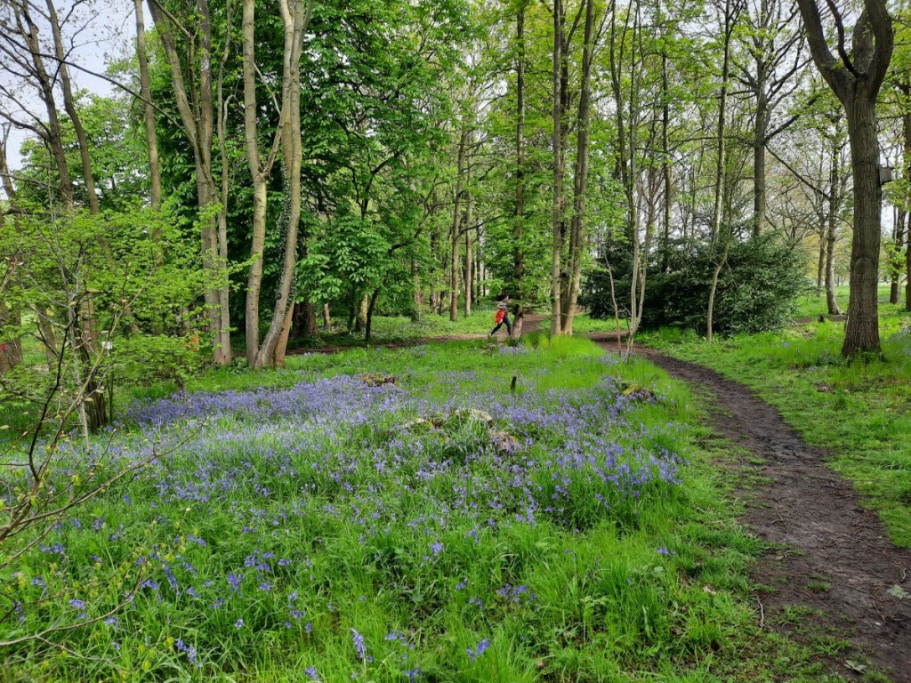
I had wondered about going for a backpacking trip to Mid-Wales, but the wet forecast made it clear that was unlikely to be a very enjoyable experience, so I opted for another local weekend instead. I was keen to visit a new parkrun on Saturday and, given the royal connection, Market Bosworth Country Park seemed the obvious choice among the various options within 45 minutes’ drive. That choice was further corroborated when the parking marshal commented, on handing me my ticket, that there were lots of bluebells to enjoy around the course this week!
It was an undulating mixed-terrain course, with a long section of uneven grass in the first kilometre, then mostly dirt trails thereafter, with a few muddy patches. With hindsight, I went off too hard at the start and paid for it on the uphills in the final 2km! Given my sub-20 run at similarly-hilly Rosliston the previous week, I was a little disappointed with the time of 20:27, even if about 15s of that was beyond the 5km mark. It was an attractive location for a run though, and there was indeed a good display of bluebells in the woods on the western half of the course.
After the run, I picked up my phone from the car to grab a few bluebell photos, jogged back to the car park machine to make my payment just before the hour was up, and headed straight home to arrive just before 10:30, thereby only missing the first few minutes of the Coronation parade to Westminster Abbey. I enjoyed watching the rest of the historical event. Rain from lunchtime onwards discouraged any further outdoor ventures.
Bluebells in Market Bosworth Country Park, and a passing parkrunner
Sunday was the one sunny day of the weekend. I spent it on a day walk from Monyash with the Gentian Club, led by Steve. We had a fairly leisurely start, meeting at 10am on the village green. Our route went all the way down Lathkill Dale as far as Alport, with lots of spring foliage and flowers to enjoy as well as the usual crystal-clear river waters and limestone crags. Helen did a good job of identifying many of the wild flowers for us, as well as a few birds and butterflies.
Heading down the upper section of Lathkill DaleFurther down Lathkill DaleA short pause by the waterfall
We then headed up Bradford Dale past Youlgreave to pick up the Limestone Way back over the fields to Monyash. With a little bit of post-running soreness in my knee, the easy pace was quite welcome to avoid further damage. I enjoyed the good company and conversation as usual. We stopped for a quick drink at a café before heading home. A map of our route can be seen here.
Looking over Lathkill DaleCales Dale
Monday was even wetter than Saturday afternoon, so I had a fairly lazy day. There was a relatively dry spell around midday which I used for a stroll around Hilton Nature Reserve. Other than that, just a few chores and band rehearsal later to end the day.
Hilton Nature ReserveBluebell woods
A few more photos from the weekend are available on Google Photos here.
I stayed close to home for the Bank Holiday weekend, joined by Ruth for Saturday and Sunday. We started Saturday at Rosliston parkrun, me running hard to finish in 19:59 (my fastest Rosliston parkrun since 2019) while Ruth jogged around with Jo, pushing Claire in the buggy on Jess’ first 5k parkrun.
After bacon sandwiches in the café for second breakfast, Ruth and I headed off to Wootton for an afternoon stroll. It was only a short climb up from the village to the ridge of the Weaver Hills, where we followed the fence-line at the edge of the open access land to reach the summit. As our arrival coincided exactly with that of a large rambling group, we didn’t linger by the trig point but descended west to pick up the little-used and overgrown public footpath through the Wredon quarries.
Heading up onto the Weaver Hills
Better footpaths led us south through farmland and woods – the bluebells not yet at their best – to reach the very attractive and well-maintained grounds of Wootton Park. We paused for lunch below Ramshorn with extensive views south over the Churnet Valley and Staffordshire plains, and faint sounds of thrill-seekers at nearby Alton Towers.
Wootton Park
We continued through the parkland and past a few ornamental lakes to pass Wootton Lodge, today the home of Lord Bamford (handy for the JCB Headquarters and factories in Rocester), which just left a short climb up through the woods back to Wootton village. A map of our route can be seen here.
One of the lakesWootton Lodge
On Sunday, we headed to Great Longstone to have a go at the first of this year’s Peak Raid MapRun events. I chose an anticlockwise route, heading northeast up onto Longstone Edge then steeply down into Coombs Dale. Then I continued generally west, over High Fields and Middleton Moor, finishing with a crossing of Longstone Moor – the only pathless running of the day – and a long zigzagging descent back to Great Longstone. I was pleased that my pace matched my plan and I finished just over 4 minutes inside the two-hour time limit, having visited 31 of the 35 controls. That puts me in 2nd place for now. Ruth also had a good run, 12th place overall and 1st female. We will see how many others can get ahead of us before the event closes at the end of August.
Once we’d got our breath back, and eaten our lunch back at the car, we went for a leg-loosening stroll over to the fields Monsal Head then back along the Monsal Trail – see map here.
Upperdale from Monsal HeadMonsal Dale from the viaduct
I was busy with the band on Bank Holiday Monday, playing at the Castle Donington May Market. We played two sets in the Market Place, and I also enjoyed listening to the Leicestershire and Rutland Pipe Band.
Pipe band in Castle Donington
A good varied weekend, and only a week until the next Bank Holiday! More photos are available here.
Unusually, we both had empty diaries, so I took the opportunity to visit my sister for the weekend. As she wanted to avoid damaging a sore knee, Ruth didn’t want to do long walks, so there was plenty of time for me to fit in a tourist parkrun to start Saturday. The chosen location was Barrow, which was about 45 minutes’ drive from Ruth’s house. Walking into the park at around 8:45, it seemed surprisingly deserted and we began to wonder whether I had somehow missed a cancellation notice, but sure enough a few volunteers were lurking in the bandstand and other runners soon began to emerge. The park is near the town centre, so I suspect a lot of the runners come on foot and don’t feel the need to leave much slack time in their travel plans!
In the end, there were 131 participants. Buoyed by my first sub-20 run for months, two weeks ago on the flat tarmac of Alvaston, I was feeling optimistic for a good time, but doubted I’d be able to achieve that milestone again when I saw the significant hill from lake to war memorial, to be tackled three times. I pushed hard though, and was pleasantly surprised to keep my average pace below 4:00/km throughout and finish in 19:47, just 2 seconds slower than at Alvaston. Four speedy under-16s beat me, two of them in under 17 minutes! Ruth walked around and photographed me at a few locations around the compact course!
Lap 1 at Barrow parkrun, surprisingly already running alone!
Afterwards, we headed north to park at the summit of the Ulpha / Birker Fell road. I had only visited these quiet hills around Devoke Water once before, so it was good to renew my acquaintance. We made an anticlockwise loop around the lake, taking in the rocky summits of Rough Crag, Water Crag, White Pike and Yoadcastle, and enjoying the distant views of the Scafell massif to the northeast, as well as towards the coast.
Looking over Devoke Water into the Lake DistrictThe summit of White Pike, with Yoadcastle in the background
The continuation over Hesk Fell, down to the pass (with a pause for lunch), and back up the other side to Great Worm Crag, was grassier and less steep, From there, it got more interesting again, and it was good to revisit the Wainwright, Green Crag, with its impressive summit tor. Three other pairs of walkers there were the only others we passed all day. Then it was just a short walk back to Birkerthwaite and the car.
Looking past Harter Fell to the Scafell range, from Green CragSetting off down from Green Crag
Once we were back in Natland, Ruth had some marking to do, so I gave her some peace and quiet and popped into Kendal to call on Ian and Emma. Great to catch up over a cup of tea, initially with Ian, then joined by Emma and the girls once they returned from a 4th birthday party.
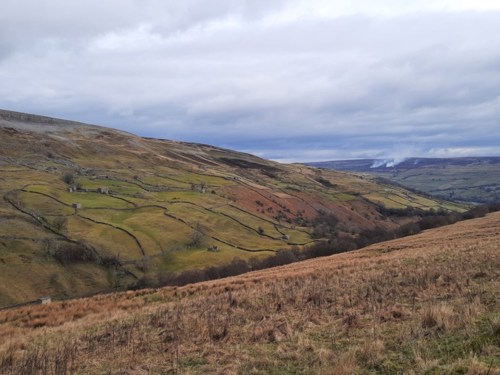
On Sunday we decided to head to the Yorkshire Dales: in particular, to Swaledale, where Ruth had a couple of unbagged Nuttalls. Looking back, I find that I’ve only made one previous visit to that valley myself, on a CUHWC weekend trip 12 years ago to the day! The drive up, via Kirkby Stephen, took around an hour. We parked in a layby just outside the small village of Muker. Once booted up, we headed north up Swaledale and then steeply up the rocky gorge of Swinner Gill – definitely the highlight of the day.
Swaledale, above MukerSwinner Gill
Once we’d gained the plateau, it was easy walking along tracks to Rogan’s Seat and then on a small path beside the fence to Water Crag, where we had lunch in the large and effective shelter cairn. The moorland views were extensive, north into the North Pennines and south over Swaledale. The terrain was pretty featureless and it didn’t look like the pathless valley from Wham Bottom would give easy walking, so we took a bearing SSE to the end of the bridleway at Blakethwaite, passing over fairly rough heather but surprisingly dry bogs.
Blakethwaite
The tracks down beside Gunnerside Gill gave more attractive walking, with natural limestone crags and various industrial remains from the once-extensive lead mining. There was a lot of lurid green grass and moss in the abandoned mining rakes, presumably affected by the minerals in the soil.
Industrial heritage by the old Blakethwaite SmelterFields and barns below Winterings Edge
The final stretch from Ivelet beside the river back to Muker gave an easy grassy finish to the day. We took the 500m detour north to the footbridge once we had confirmed that there was no easy crossing available on the direct path. I paused at Ruth’s for dinner before hitting the road for a quiet and undelayed drive back home. Great to revisit two quiet but pretty areas that I had only been to once before. And less than a week until my next trip to the Lake District!
Maps of our routes are available here (Birker Fell) and here (Rogan’s Seat), and more photographs here.
Usually, the weekend after New Year, a few of us from Rolls-Royce (Derby) Band take a trip to Butlins in Skegness for a social weekend at the annual Mineworkers Contest. However, there was no contest held this year, so I organised an alternative, “(not)Butlins” weekend away. The destination was Ironbridge, where we stayed in the spacious and well-equipped YHA hostel at Coalbrookdale.
As the lead booker, I felt I ought to arrive promptly on the Friday afternoon, so I got an early finish from work at around 2:30pm, picked up Becky from Littleover, and drove down to arrive in Ironbridge around 4pm – a surprisingly smooth journey for a Friday afternoon. Jeff and Helen had arrived a few minutes earlier and opened up. They had volunteered to lead the group catering, so we helped them unload the groceries into the large commercial kitchen before getting the kettle on and starting some advance food preparations for Saturday dinner. The others – 21 of us in total – arrived over the course of the evening and we had a sociable evening over dinner and a few drinks.
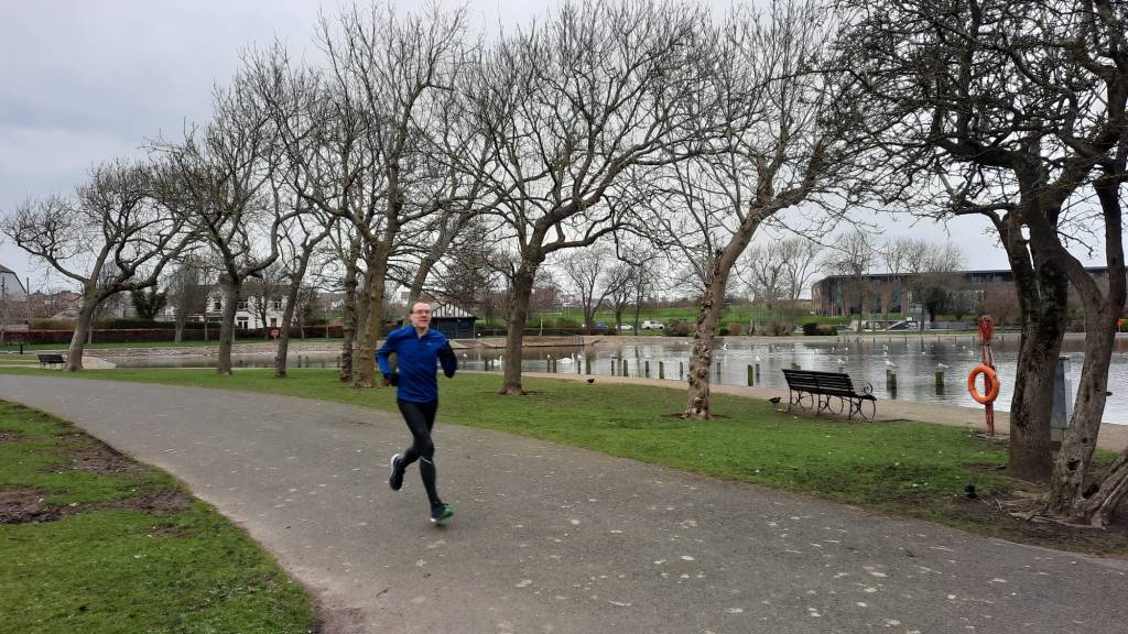
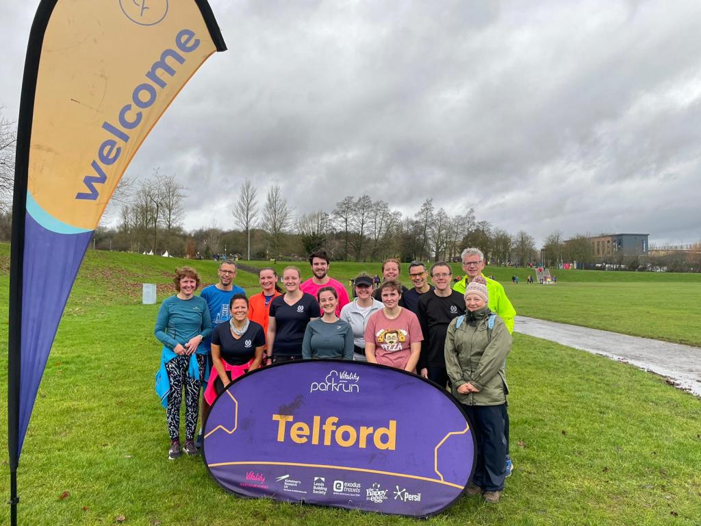
Saturday began with most of us heading to the nearby Telford parkrun. Fortunately, fairly heavy rain as we drove into town began to ease by around 8:45am and had fully stopped by the time the race briefing was underway, so we avoided a soaking! The course was comprised of two laps, one short and one long, mostly on tarmac, with a significant downhill to start and, of course, a significant uphill back up to the finish. I was first finisher from our group (as usual), but Tim’s run, around 90 seconds slower than mine, achieved by far the highest age grade, just over 70%. I strolled back down to the bottom of the hill to run back up with Heather D offering ‘encouragement’. She and several others ran good times. Afterwards, we got coffee and cakes at Costa before returning to the hostel.
Team photo after parkrun: Jane, Tim, Heather H, Hayley, Ashleigh, Jake, Meg, Heather D, Becky, Helen, Jeff, me, Will and Janine.
For the afternoon, I led some of the group on a walk up The Wrekin, while the others went for a sightseeing stroll by the bridge and river. We took the main path up from the east, enjoying clear views in all directions in the sunny spells. It was dramatic to see the flooded River Severn below, with the main Shropshire hills beyond. We continued along the ridge to descend to the lane to the west, then took lower-level tracks around the south side of the hill back to the cars.
Setting off from the summit of The WrekinDescending the steep west ridge
We were back at the hostel by teatime to shower and change before a big effort to prepare the group dinner under Helen’s leadership. After the meal, the evening continued with drinks and games in the lounge until late.
Sunday started with a full cooked breakfast together, after which we cleaned up and packed away all our stuff into the cars to check out by 10am. A few headed home or to other commitments, while most of us returned to the Ironbridge riverside for a stroll and/or coffee at a café. After that, we headed to the Exotic Zoo, close to where parkrun had been held in the Town Park, to potter around looking at the animals before another café stop for lunch before the drive home.
The Iron Bridge
In summary, a well-attended and very enjoyable social / team-building weekend away for the band before our main preparations begin for the Midlands Championships at the end of February. Perhaps, if the Butlins contest doesn’t resume, we’ll do something similar again next year.
There are a few photos here, and a map of our route up The Wrekin here. Telford parkrun results are here!
A local weekend this week, but a well-filled one! Saturday morning started with a volunteering session at Rosliston parkrun. This was my 25th time volunteering, earning me a T-shirt, so I marked the occasion by picking my favourite role, timekeeping. I arrived quite early so had time for a peaceful stroll around the forest before the run started.
Morning reflections before parkrun
After parkrun, I headed up to the White Peak for an afternoon stroll, taking advantage of the fair weather after lots of rain recently. I parked by the church in Elton. My first objective was one of the eight hills on the ‘Ethel’ list that I hadn’t bagged prior to that list’s creation, Harthill Moor. I would dispute whether the designated location is really the summit of a hill at all, as it has minimal prominence and there are several higher points further up the broad ridge, but it does have the distinction of a trig point. The “summit” offered decent views to the north and west.
The disused quarry on Anthony Hill
From there, I descended northwest into the head of Bradford Dale, and followed the valley downstream as far as Youlgreave, pausing for a late lunch on one of the benches.
Bradford Dale
I then followed the Limestone Way up to Robin Hood’s Stride, always a worthwhile objective with its distinctive rocky tor. That just left a short walk down past Dudwood Farm and back up to Elton.
Autumn colours near Harthill Moor FarmRobin Hood’s Stride
On Sunday was the third of this year’s series of four Peak Raid 3 events (I had missed the second for the last Gentian trip, but can still quality for a series result as they take the best three results). The venue this time was the Goyt Valley, to the west of Buxton, with registration at Errwood Sailing Club. Ruth had decided to come down from Kendal to take part too, so we met in the large car park on the west side of the reservoir dam, and walked over to the start together. Although they had been forecasting rain or showers all week, it actually turned out to be a fairly sunny morning, the heavy rain having fully passed overnight.
Pre-race sunshine over Errwood Reservoir
The race went fairly well. I opted for a clockwise route, taking in 15 of the 19 controls and earning 500 out of a maximum 600 points. With hindsight, I did not visit the controls in the middle part of my route in the most efficient order, and could have saved nearly 1km and 90m ascent, perhaps saving enough time to visit an extra control within the three hours. I was happy with the start and end of my route though, and enjoyed the strenuous running through varied terrain and scenery. I finished with just 6 seconds to spare – judged to perfection! By chance, I had also passed over the summit of another of my missing Ethels, Foxlow Edge.
My chosen route
Ruth had also had a good run – a slower pace than mine but she had partly compensated for that by spotting that more efficient route. After we’d recovered and enjoyed the usual post-race coffee and flapjack in the clubroom, we returned to the cars, got changed, and then headed into Buxton for a café lunch and more discussion of our routes before we set off back to our respective homes.
Ruth and I had said many times over the years that it would be really interesting to enter a mountain marathon together and see whether we’d be a competitive pair. 2022 was the year it became a reality, and we picked the inaugural Kong Mountain Marathon, to be held on the Isle of Arran. I’ve enjoyed several of Kong’s ‘Mini Mountain Marathons’ in the Lake District over the last few years – four-hour score events – so was keen to support the organisers in their attempt to re-establish a Scottish mountain marathon following the demise of the LAMM and Highlander.
For the uninitiated: a mountain marathon is not a marathon held on mountainous terrain. It’s an endurance race held over two days (generally), with pairs of runners backpacking through the mountains via a series of checkpoints, only made known at the start of the race. The course is unmarked and you’re responsible for your own route choice and navigation, and have to carry all the kit and food required for the two days and overnight ‘mid-camp’. Generally there’s a choice of linear courses (a set of checkpoints to be visited in order) and score courses (score as many points as possible by visiting checkpoints in a time limit). For this event, we chose the middle of the three linear courses (‘B’), which we hoped would present a achievable challenge. (Even if we’d wanted, we weren’t eligible for the ‘A’ course, neither of us having previously completed a similar event.)
I took the Friday off work to make the journey up to the Highlands easy. We shopped for race provisions in Kendal in the morning, then made our way north to Ardrossan, where we enjoyed fish and chips for lunch. We then headed to the port to catch our 3:20pm ferry to Brodick, a fairly quiet and very smooth crossing, with lots of other race competitors also travelling as foot passengers.
Once on the island, it was only a 15 minute walk along the sea front to Arran Sports Association, which was the location of the event centre and base camp. We pitched our big tent (on the rugby pitch!), went to registration to collect our SI cards and commemorative T-shirts, and then enjoyed the pasta dinner offered at camp. A folk band provided ceilidh-style accompaniment inside, and the local pipe band unexpectedly (at least by us!) turned up for a rehearsal outside. We got a fairly early night to be as well rested as possible before the race.
Base camp in Brodick at sunset
On Saturday morning, we had a fairly early start to have our breakfast (bacon rolls again laid on by the race organisers) and pack up our race bags. Paring down our kit a bit compared with our regular Highland backpacking list, we easily fitted everything into 32 litre rucksacks that didn’t feel too heavy on the back. With hindsight, and with a bit of refinement, we might just about have managed with 25 litre bags (not that I own a suitable one!).
It was a couple of kilometres’ walk to the start, the other side of Brodick Bay at the Castle, and a very scenic walk along the beach in the sunshine at that. Our allocated start window was 8:30-8:45am, and we were underway promptly at the start of that period. We picked up up our maps and control cards and spent a few minutes marking on the map which 10 of the 70 controls we needed to visit that day. It turned out, as we’d guessed, that the mid-camp was in Lochranza at the north end of the island.
Our strategy was that, as the stronger runner, I would take the lead on the navigation, to allow Ruth to concentrate on just covering the ground as quickly as possible. The day started with a few fairly flat kilometres on paths into Glen Rosa, which we could mostly jog. Then the going got steeper, with a long climb up Beinn Nuis, taking a couple of diversions off the path to visit controls 2 and 3. Control 4 was by a rocky outcrop, just off the summit.
On the way up Beinn Nuis
That was pretty much the end of the path-work for the day! A descending traverse north took us over quite rough ground to control 5 at a stream junction in Garbh-choire Dubh. Then we turned west for a long, hard trudge through Glen Iorsa – exceptionally tussocky! – and past the south end of Loch Tanna to reach control 6 by the higher-level Dubh Loch. Next, heading northeast, we ascended onto Beinn Tarsuinn’s west top and control 7 (the 556m Beinn Tarsuinn, that is, not the Corbett).
Looking back across Glen IorsaClimbing above Loch Tanna
From there, we contoured around Beinn Tarsuinn’s east top and the slopes of Beinn Bhreac (more awkward ground) to reach the minor summit of Beinn Bhiorach (control 8). Some boggy but welcome trods eased progress from there down to control 9 by the Abhainn Bheag (river), before the trickiest navigation of the day led us down to control 10 on the coast path. That just left a flattish run-in to the finish by the castle on Loch Ranza. We were glad to reach the end of the day, but not totally exhausted, probably because the terrain had necessitated a high proportion of walking, and we’re well practiced at long, hilly walks!
We called in at download in the village hall before heading to mid-camp, a little further up the road at an outdoor centre. Soon we’d pitched our tent and done some useful refuelling and rehydration. It had stayed pretty sunny all day, but we could see that it was clouding over quite quickly, so decided to cook our dinner (flavoured couscous, as usual when backpacking) quite early, around 5pm. This proved a good decision as by 6 there were a few drops of rain falling and the midges had started to come out for dinner too! We escaped both by heading back to the village hall, where we could look at the results for the day, and see maps of all the courses. We were pleased to find that we’d finished in 6th place for Day 1, out of 43 pairs on our course. The organisers had put on a ceilidh for the evening. Like most of the race participants, we saved our energy by enjoying the music but not dancing!
Light rain continued on-and-off through the night, but had just about stopped by the time we were thinking about getting up, around 6:15am. It didn’t take very long to have our breakfast and pack up, and we were on the start line for Day 2 by around 7:15. We had thought the course would be significantly easier than Day 1, but it turned out only to be slightly shorter in distance, and with similar ascent. Lucky we hadn’t used up all our energy!
The start was up Gleann Easan Biorach for a short distance, then very steeply uphill onto the crags of Torr Nead an Eoin (control 1). We’d have located it more quickly if we’d read the control description, telling us it was above the crag, not below in the gully as I’d incorrectly inferred from the map! We then had a boggy jog on various trods along the Clachan ridge and down to the main road. It was back to walking pace as we climbed straight up the other side (via control 2 at a fence corner) to the ridge of Fionn Bhealach and very steeply back down (through heather and bracken – not much fun) to the coast near Millstone Point (control 3).
Then came the easiest running of the event, several kilometres of flat coast path to North Sannox, where control 4 was near the far side of the stepping stones across the river. Then came the main climb of the day, initially on paths to control 5 by the stream below Coire na Ciche, then much more steeply and roughly south onto Am Binnein (control 6). We were glad to reach the flatter, rockier ground of the ridge, which had traces of a path, and very good views of Goat Fell and the coast.
Ruth on Am Binnein
The hard work was now mostly done. We followed the ridge up to the summit of Goatfell (control 7 was hanging on the trig point), and then jogged down the tourist path to control 8 by Cnocan Burn. Forest paths then led us down via the final control to the finish, back at Brodick Castle. A classic finish to a great mountain expedition! We had covered a total of around 57km and 2800m ascent over the two days.
Cir Mhor and Caisteal Abhail
We were randomly selected for a kit check, so had to show the finish marshal that we did indeed have everything on the mandatory list. Then we ambled back along the beach and coast path to Brodick village to download our results. We got changed into clean clothes, then enjoyed the vegetable chilli and cakes provided for lunch, although we felt the portions were a bit disappointing!
Having taken down the base camp tent and packed our bags, we returned to the download room to check out the results, and were pleased to find that we’d gone one better to come 5th for Day 2, and that that had been enough to move us up to 5th place overall! 14 of the 43 pairs had failed to complete the full two-day course, as had 9 of the 18 on the ‘A’ course! So we were quite proud of our result on our first mountain marathon!
We caught the 4:40pm ferry back to Ardrossan and drove back to Ruth’s house for the night, and I continued to Derby on Monday morning for an afternoon of washing, drying and sorting gear.
In summary, a really enjoyable weekend in the mountains, and definitely the type of event I’ll do again. I gather that the event didn’t quite break even, so I hope that the organisers do find a way to make it profitable and organise more editions in future years. It was very well organised, with well-designed courses to provide physical and technical challenge, and deserves to be a success.
Heading abroad for the first time since the pandemic, I took a long weekend in Switzerland to visit Alex and Ausma, who relocated from the Black Forest a couple of years ago. They are now based in Yverden-les-Bains, at the south end of Lac de Neuchâtel. I flew with easyJet from Manchester to Geneva, taking the Thursday afternoon off work to drive up to the airport. I was pleased that, despite the airline’s suggestion to get to the airport two and half hours early to clear security, I was through in 30 minutes leaving plenty of time for an early dinner before boarding. The flight was also on time, arriving around 9pm, and with no queues for passport control I was soon on the train. With typical Swiss efficiency, the short connections in Geneva and Renens went smoothly, and I made it to Yverdon by 11pm. Alex and Ausma met me at the station, from where it was only a few minutes’ walk to their flat near the lake.
Friday was a fairly leisurely day spent in and around Yverdon. We started by cycling around the lake shore to Grandson, where Alex and Ausma went for a short swim in the lake, as they often do. Then we went for a coffee at the café at the castle. Ausma headed home while Alex and I continued our bike ride through a few neighbouring villages to call in at a few farm shops to pick up provisions for the week. We rode through a few spots of rain, and just made it back to Yverdon before a lunchtime downpour.
Looking over a sunflower field to Mont de Baulmes
In the afternoon, Alex had to dial into a meeting for a bit, so Ausma took me on a tour of the local nature reserve and along the lakeside, where there were lots of water birds and good views over to Grandson. In the evening, we enjoyed a barbecue with local chicken and sausages on the balcony.
Looking over Lac de Neuchâtel to Grandson
Saturday was forecast to be a much sunnier day, so Alex and I took a train trip to the bigger mountains near Martigny. A rack railway leads from the town over a pass to Chamonix and beyond. We just went up a few stops to the village of Les Marécottes, from where we took the gondola up to the hamlet of La Creusaz, saving ourselves around 800m of ascent through the forest. Our objective for the day was the scrambly peak of Le Luisin, at a lofty 2786m. An alpine path, marked in blue on the map and signs, leads directly up the ridge from La Creusaz, initially zigzagging up through forest and brush. As we gained height, we soon gained excellent views of the Mont Blanc massif, as well as down into the valley at Martigny.
Looking towards the Mont Blanc massifAlex on the ridge, with views of Dent d’Enaney
The path gradually got rockier further up, with short sections of easy scrambling protected by fixed ropes and cables, and very dramatic views down huge gullies both sides of the ridge. The views over Vallon d’Emaney were particularly fine. The final section to the summit was steeper, slightly trickier scrambling with the aid of a couple of short fixed ladders.
Looking over Vallon d’Emaney towards Mont BlancThe crags of Le Luisin
The summit was actually in mist as we arrived, so we settled down for lunch a short distance along the ridge in hope that it would clear to reveal the full view. We were in luck, and the mist gradually lifted off so that we could see Mont Blanc again, as well as the nearby peaks of Dents du Midi, Tour Salière and Fontanabran.
Tour Salière
After lunch, we descended by the easier, red-signed path to Col d’Emaney and then down into the head of Vallon d’Emaney, with the impressive strata of Pointes d’Aboillon above. Once in the valley, the walking was easier for a while, on larger tracks. We paused at a ‘buvette’ (mountain café) for a drink, before continuing down the valley. A long, steep descent through the forest eventually brought us down to the railway station at Trétien, just a couple of stops up from Les Marécottes,. A couple of hours of travelling brought us back to Yverdon, where Ausma had prepared burgers to barbecue for a well-earned dinner! Route map for the day: https://www.plotaroute.com/route/1990073
Looking back up Vallon d’Emaney
Sunday was another sunny day. Alex and I headed to a ridge with distant views over Yverdon and the lake, close to Montreux. Today’s mountain railway wasn’t quite steep enough to need rack propulsion, but still took an impressive route with zigzags and tunnels under the Col de Jaman to the hamlet of Allières. We headed steeply uphill on quiet footpaths through pasture land and patches of forest to the farmstead at Orgevau and on up to the head of the valley at L’Urqui. There were good views down the valley towards the adjacent mountain group of Vanil Noir.
Looking towards Vanil Noir
At L’Urqui, we left the path and headed up through rough grass to reach the col between Le Pila and Vanil des Artses – a knife-edge grassy arête! Alex led me on a route he’d taken previously, up the crest of the very dramatic ridge to the summit of Vanil des Artses (1992m). I was glad of his local knowledge to reassure that it was actually easier in descent, and locate the fixed cables that protect the most exposed section, traversing along a grassy ledge above cliffs just off the crest of the ridge.
The narrow ridge to Vanil des ArtsesLe Pila and beyond, from the summit of Vanil des ArtsesLooking north to Dent de Lys
Having admired the view from the summit for a few minutes, we retreated the way we’d come until we were past all difficulties, then paused for lunch while contemplating the route up Le Pila the other side of the col, where the guidebook advertised ‘practically vertical vegetation’! A few lines looked plausible, but it was very hard to judge the gradients and the sizes of the rocky steps from a distance.
Once we’d moved closer, a steepening grassy ramp on the right hand side seemed promising, but after a while we reached some very steep and exposed steps that we were not convinced we’d be comfortable to descend, and turned back. It looked like another rake a little further left might be easier, so we gave that a try too, getting slightly higher up and tantalisingly close to the ridge line, but again decided it was too risky to continue. Perhaps Alex will feel braver or find a better line another day and be able to lead me next time!
The view from part-way up Le Pila, towards Vanil NoirVanil des Artses
To make a circular walk, we contoured around below the crags of Le Pila to cross the col to Joux des Heures. Easy paths led us down the valley from there to the station at Les Cases, where we got ice cream at another buvette as we waited 45 minutes or so for the train. Once back in Yverdon, today’s culinary treat prepared for the barbecue by Ausma was salmon and prawns, with chips and salad – delicious! Route map for the day: https://www.plotaroute.com/route/1990084
Monday was my final day of the visit, and was a public holiday in Switzerland, Swiss National Day. After two fairly long train trips into the mountains at the weekend, and with a long journey for me at the end of the day, we opted for a more leisurely start and a day spent nearer to Yverdon. The Jura mountains run west of the town and lake, and Alex suggested we go for a trail run up the highest nearby peak, Le Chasseron. We caught the rail-replacement bus up to the small town of Sainte-Croix, from where it was about 5km and 600m climb on pleasant footpaths, initially steep enough to merit walking as we ascended the forest, but then more runnable on the gentler open ridge to the subsidiary peak of Petites Roches, then a little down and back up to the main summit at 1607m.
Petites RochesAlex on Le Chasseron
After a pause for photographs and water, we continued a little further north along the ridge before dropping down west to Chalet des Roches Eboulées. From there, undulating footpaths led us back through the forest to Sainte-Croix, for a total run of around 15km and 750m ascent. Route map: https://www.plotaroute.com/route/1990096
After salad for lunch back in Yverdon, we went for another short bike ride to the lakeside for the Tucks to swim, and then it was time for me to head to the station to start the journey home. This time I caught the express intercity train directly to Geneva Airport, where I again had a smooth passage through security. Not so lucky with the flight this time, with an advertised delay of 60 minutes that gradually increased to 90 and, by time we took off, 120. That meant I wasn’t back in Manchester until just after midnight. I finally made it home around 1:45am and was glad to get to bed.
It was fantastic to get away to some larger mountains again after three years in the UK, and to spend time with Alex and Ausma again and catch up on all the developments in their lives – the new location, jobs, Swiss Birman cats, and a baby on the way! Now for a few days at home, before heading back out to Switzerland by car for my main summer holiday!