After our weekend on Skye, we headed further north for the next few days of the holiday. We had a night of relative luxury at the Caledonian Hotel in Ullapool, then drove up to Assynt for a walk up Braebag, a Corbett outlier of Ben More Assynt. The main unusual attribute of the hill is its limestone geology, a rarity in the Highlands, and this was apparent straight away as we walked up Allt nan Uamh to a spring where this significant river wells up apparently from nowhere. The valley is dry beyond this point, except in spate conditions, and we passed several caves and a dry waterfall before eventually finding flowing water again high on the slopes of Braebag.


Sadly the conditions that day meant that a thin sheet of cloud was flowing briskly over Braebag all day, from east to west, and from the summit we only had very fleeting glimpses of the view over Assynt, whenever a gap in the cloud passed over our location. We sheltered in the summit cairn for at least half an hour, hoping for improvement, but none came, so we descended by more-or-less the same route, taking a short detour to explore the largest caves a bit more thoroughly.

That night we camped semi-wild, in an idyllic spot just off the road at the head of Loch Assynt with a view of Ardvreck Castle.

The next two days had a dry forecast so we opted to tackle the most strenuous of our planned walks for this trip, a one-night backpacking expedition from Strath Carron (the one near Lairg) to the very remote Corbetts of Carn Ban and Carn Chuinneag. We set off around 9am from Glencalvie Lodge, heading initially up the large tracks of the Alladale estate, run as a project to return the Highlands to its natural ecosystem with a hope of re-introducing wolves as the apex predator. Luckily there are not yet any wolves to trouble hillwalkers!
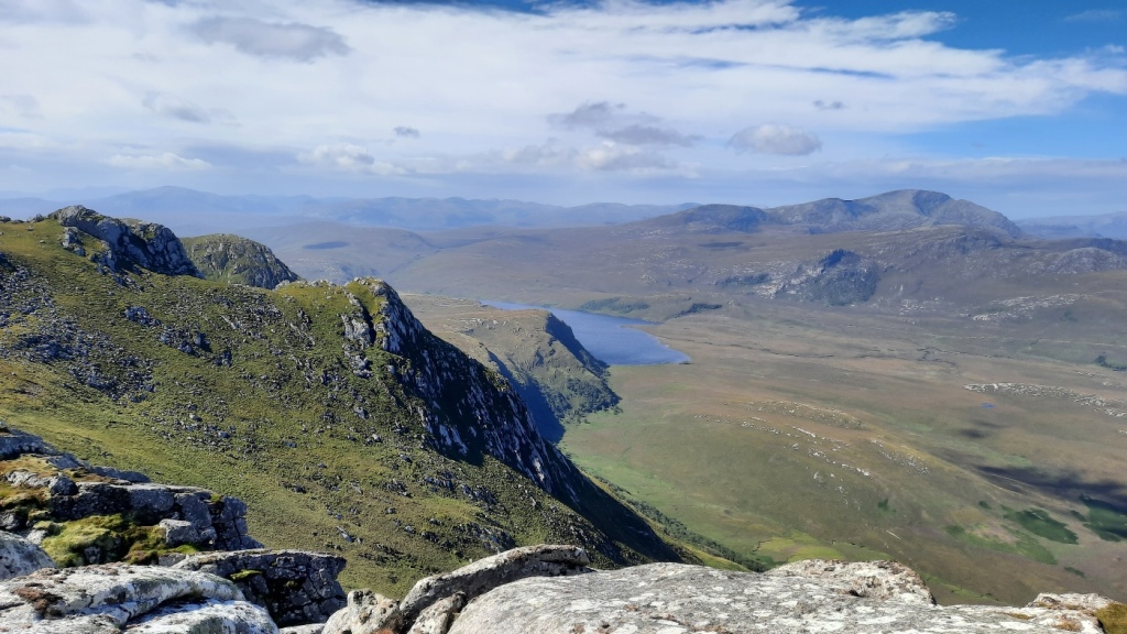
We were pleased to find that a branch of the track had been built onto the long ridge of An Socach, not marked on my ten-year-old map, saving us a rough slog through deep heather. The valleys either side the ridge were filled with cloud but the ridge crest was just high enough to be clear and make the navigation easy. Quite a few miles of fairly easy walking took us over the summit of An Socach, then down and back up to Bodach Beag, which gave grand views over a large corrie to our first target, Carn Ban, perhaps the most isolated of Corbetts. Another descent and re-ascent around the head of the corrie led us to the summit, where we enjoyed the views of Seana Bhraigh, the Beinn Dearg hills and Assynt as we ate our lunch.


From there the route continued south along the main ridge of Carn Ban then steeply down a zigzagging stalkers’ path into Gleann Beag. We followed the large track down the valley for a few kilometres then struck off onto rough, pathless ground again to re-ascend to Crom Loch, which we had picked out as a suitably high and breezy place for a summer wild-camp. The best patch of flattish ground we could find turned out to be close to where an upturned rowing boat had been left on the shores, which served as a comfortable bench for us! It must have been a mission to get the boat here, as it’s tussocky ground all around the loch and there’s no track nearby!


We were glad that the good breeze we had enjoyed all day continued as we set up camp and cooked and ate our dinner, and was enough to keep the midges totally at bay. However, mid-evening the breeze suddenly disappeared and within minutes we were forced to dive into the tent for the rest of our visit, the density of the midge swarm being the worst I’ve ever experienced. There was an audible hum as they buzzed around the outside of the tent, trying to find the tasty carbon dioxide source, and the outside of the flysheet was black with midges at times, sliding down as they clambered over each other! Conditions were not much improved in the morning, so we ate our breakfast inside and got ourselves sealed up with head nets, gloves, and trousers tucked into socks before venturing outside safely to take down the tent and pack up. Luckily our sealing proved effective!
The mist had descended overnight so, once we’d reached the western end of the loch, we needed to follow compass bearings and count paces over the fairly featureless ground for a few miles to reach the minor summit of Creag Ruadh. There we just about came out of the cloud sufficiently to be able to identify which way the ridge was leading, and follow it onward to the unexpectedly-bouldery twin summits of Carn Chuinneag, the second (and higher) of which is marked with a trig point. This brought the cross-country section of the expedition to an end, as a good stalkers’ path leads all the way down into Glen Calvie to join an estate track back to the lodge. Despite the midges overnight, it was a really enjoyable trip into a true wilderness area where we had seen almost nobody over the two days – just a pair of people in the distance in Gleann Beag and one man walking up Carn Chuinneag as we walked down.

For the next two nights, we stayed at the comfortable and welcoming Carnbren B&B in Lairg. This was about as convenient a base as can be found for our next two objectives, Ben Loyal (up by Tongue on the north coast) and Ben Hee (at the other end of Loch Shin to the northwest). We had a leisurely start on Thursday, enjoying the full Scottish breakfast before embarking on the one hour drive along single-track A-roads to Tongue. After a greyish start, the day became clear and sunny, particularly in the far north – perfect for what is one of the most iconic and celebrated mountains in the Highlands!
We started our walk at Ribigill, following tracks and then small paths most of the way up onto the ridge, with only the last couple of hundred metres of ascent made over steep, pathless grass! This brought us to the northern top of Sgor Chaonasaid, an impressive rocky tor with even more impressive views of Ben Hope to the west, the Kyle of Tongue to the north, and the whole of Caithness to the northeast, with Orkney visible in the distance. We enjoyed the view for a while then continued south to the highest summit, An Caisteal, then on to the south top, Beinn Bheag, before returning roughly by our route of ascent. A short but awesome walk over a really grand peak!


We were less optimistic about conditions for Friday on Ben Hee, with frequent and heavy showers forecast, but when we set off from West Merkland it was dry and the summits almost clear. A small stalkers’ path leads up the corrie most of the way to summit, making for easy progress up the not-too-steep ground. The cloud cleared the top just as we arrived, unveiling good (but still fairly grey) views of Ben Hope, Ben Klibreck, Foinaven, Ben Stack and Quinag, to name just the most distinctive peaks. We descended by the same route, passing one other bagger on the way, an elderly gentleman who must have been in his late 70s but still making good progress over rough ground in the hills. A few spots of rain fell at times, but with hindsight we could have got away without waterproofs all day!


We ended the day with a drive to Dingwall for a night in another B&B, en route to the final phase of the holiday, which was to be spent in the Cairngorms.
Maps of our routes can be seen via the following links:
Braebag: https://www.plotaroute.com/route/1255822
Carn Ban and Carn Chuinneag: https://www.plotaroute.com/route/1255830
Ben Loyal: https://www.plotaroute.com/route/1255833
Ben Hee: https://www.plotaroute.com/route/1255834
My full photo album is available here: https://photos.app.goo.gl/dvmP1CUEjo76Y2288


