Ruth and I took a five-day trip to the Highlands to bag a few more Corbetts at the start of her half term holiday. We drove up as far as Perth on the Friday evening and stayed in a Travelodge for the night, which was far enough north for our drive to Garva Bridge, up the valley from Newtonmore, to be manageable before our walk the next day. As it turned out, the forecast was for improving conditions as the day went on, so we had quite a leisurely start and set out walking at around 10:30.
The first section was up the lane along the glen to Melgarve, getting the lower-level walking done first to give the hills time to clear a bit. From there, it was a fairly steep, pathless ascent over fairly easy ground to the ridge of Gairbeinn. A shower came through as we ascended, transitioning from rain to sleet and eventually snow as we gained height and the temperature dropped. It settled for long enough to make the ground white as we traversed the ridge over and beyond the summit, but soon melted again as the sun came out as we descended east.


A pair of parallel lines of fence posts made for easy navigation across the high plateau, and also kept us clear of the roughest and boggiest ground, so we made good time to Meall na h-Aisre, our second Corbett of the day. From there, reports on WalkHighlands had revealed that a new track had been built to service an underground cable from the nearby wind farm, not yet marked on the OS maps, and we were able to pick this up not far below the summit and follow it all the way back into the valley, leaving just a couple of km back along the lane to the car.


We headed to Glen Nevis SYHA for the night, where we had a smart and comfortable twin room. The next day we set ourselves two more Corbett objectives, a bit of a drive apart but each only a walk of around 3 hours. We set out from the hostel before dawn as the forecast was for the weather to deteriorate through the afternoon this time. First up was Meall Dubh, an obscure but prominent hill in the area between Glen Garry and Glen Moriston. Much of the hill has been covered with a new wind farm, and the sprawling service tracks have made the ascent of the hill from the west much quicker and easier than it used to be! We picked a route using the tracks where convenient, but cutting directly up the hillside to avoid large zigzagging detours. The tracks led us around 1km south of the summit, from where it was a simple climb up grassy ground to the summit – sadly in mist but we had enjoyed views over Loch Loyne and Glen Garry during most of the ascent. We returned by a similar route with a couple of variations that turned out to be rougher and boggier than the ascent route! A few spots of rain had blown through at times but not enough to need waterproof trousers.

Second up for the day was Carn Dearg, east of Glen Roy. We parked and crossed the bridge over the River Roy at the foot of Coire na Rainich, then followed the east bank south as far as Brunachan Bothy, pleased that the rain had still not arrived. From there, it was a steep and pathless ascent up Coire Dubh and from there up the west ridge of Carn Dearg to the summit. From there it was a short walk north into the very steep head of Coire na Rainich. Once down this awkward and very slippery ground, it was an easy walk down the rest of the corrie to the car. Light, wind-blown rain gradually increased through the walk, but never amounted to much really, and we were happy to end the day without seriously-wet gear.


On Monday we had booked onto the afternoon ferry from Uig (Skye) to Tarbert (Harris). With another early start for the drive from the hostel, this gave us just enough time to nip up a Corbett Ruth needed at the bottom of Glen Shiel – Sgurr an Airgid – in the morning. Although we set out in the dry, this was the wettest walk of the trip with light but persistent rain soon setting in. A good stalkers’ path made for easy going up to the bealach and from there up the ridge right to the summit, and an equally easy descent. Sadly, low cloud prevented views, except looking over Loch Duich from the lower slopes.

A further 90 minute drive got us along the coast to Kyle and all the way across Skye to Uig, with a little over an hour to spare before last check-in for the ferry. The crossing was surprisingly smooth after windy weather over the weekend, and we were greeted on the approach to Harris with a very intense rainbow over Scalpay.

Once disembarked in Tarbert, it was only a few minutes’ drive to our hostel accommodation in Drinishader. We were pleased to find that we had the whole hostel to ourselves, including use of the self-catering kitchen. We spent the evening eating, drinking tea, and drying out all our wet gear in front of the coal fire.
Another early start was called for on Tuesday, as a band of heavy rain was forecast to arrive on Harris around noon, and we were keen to get as far around the An Cliseam Horseshoe as we could before it arrived. It was only a short drive to Gleann Sgaladail from where our walk would start at sunrise (a not-too-uncivilised 7:30am!). The first part of the ascent was on the ‘Harris Walkway’ path up onto the shoulder of Tomnabhal. Easy grass and slabs led us from there to the top of Tomnabhal, with good sunrise views east over Loch Seaforth from part-way up.

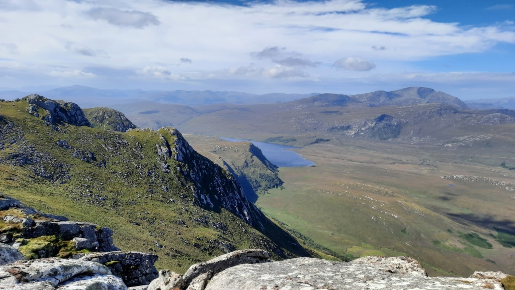
The top was in cloud though, so we took a bearing down to the bealach before climbing steeply but easily back up onto the summit ridge of An Cliseam. Frustratingly, we could tell that the summit was just a few metres too low to enjoy inversion conditions, and we had to make do with just fleeting glimpses of the hills and lochs both sides. However, descending west to the next bealach brought us back out of the cloud, with very good views south to Loch a Siar and north over the corrie.

A small but well-trodden path led us easily over Mulla Fo Dheas to Mulla Fo Thuath, where the cloud cleared out fully to give good views west to the neighbouring Graham, Uisgneabhal Mhor – looks like a good hill for another day! After a scenic lunch break looking north over Stuabhal and Loch Langabhat, we continued over Mullach an Langa and then east over pathless but fairly easy ground to Gleann Sgaladail. By then, the summit of An Cliseam had cleared and we enjoyed looking up at it, but only for a short while before we could see that the expected rain had reached the higher parts of the ridge. Pleasingly, however, we made it all the way down the valley to the car before the rain reached the lower ground, and completed the entire walk without getting wet at all! A really good day (well, morning!) in these attractive hills.


We returned to the hostel for the afternoon to drink tea as the heavy rain passed over. As it had cleared out again by 3:30pm, we decided to pop across to the west coast to enjoy the end of the day on the celebrated white sands and dunes of Luskentyre Beach. This proved a great decision as the sunset was spectacular over the bay to the southwest. A beautiful end to the day and our short visit to Harris.


In the morning, we caught the early ferry back to Skye. The plan had been to tick off another Corbett in Glen Shiel, but Ruth’s knee was sore and the rain was heavy and persistent, so we instead made contact with Amy Ottway to arrange to meet up for a coffee and chat in Kyle. Then the rest of the day was spent on the long drive back to Kendal, pausing in Fort William for lunch.
All in all, a really enjoyable trip, making good use of the best bits of the weather and with the full range of autumnal conditions! Five new Corbetts for me over the course of the trip leaves me with only one remaining: Streap, near Glenfinnan, which I hope to climb at Spring Bank Holiday next year.
Maps of our routes are available here:
Gairbeinn and Meall na h-Aisre: https://www.plotaroute.com/route/1330010
Meall Dubh: https://www.plotaroute.com/route/1330016
Carn Dearg: https://www.plotaroute.com/route/1330029
Sgurr an Airgid: https://www.plotaroute.com/route/1330030
An Cliseam: https://www.plotaroute.com/route/1330036
My full photo album is available on Google Photos here: https://photos.app.goo.gl/1VgLB5EvuweS4urr8