Gentian Blencathra Trip (10th-12th March 2023)

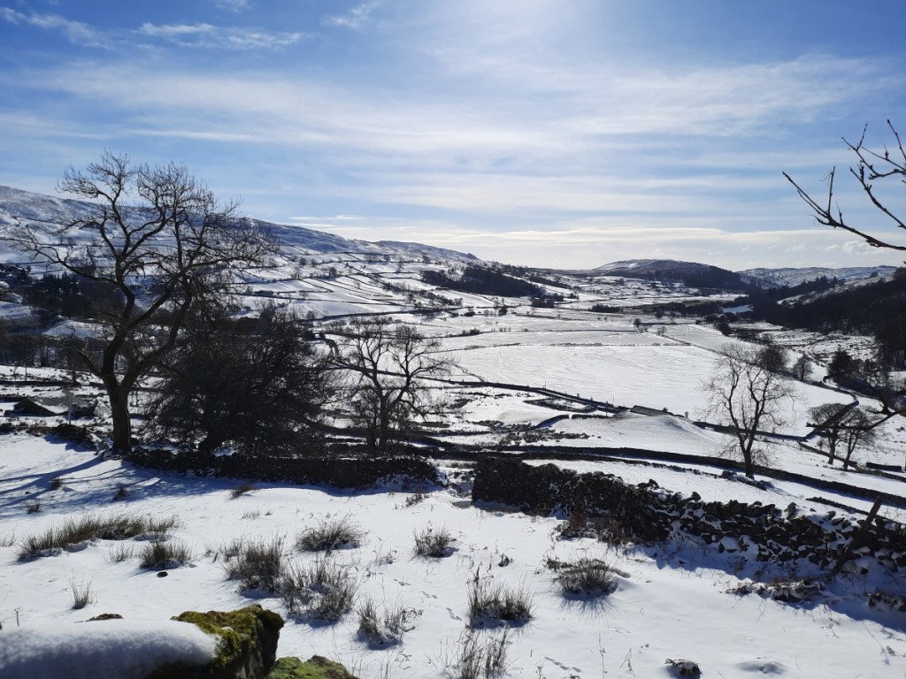
Only a week after my previous visit, I headed back to the Lake District for another weekend, this time with the Gentian Mountainering and Hill Walking Club. Coincidentally, all my previous weekend meets have been in Wales, so this was my first time with them in the Lakes. Using up another left over day of 2022 annual leave, I again took the Friday off work to enjoy an extra day in the hills. Thursday had been a snowy day in northern England, so I had been worried that the evening drive up to Ruth’s house could be difficult, but it turned out that the roads were totally clear, with nothing worse than sleet falling.

I had advertised my intention to walk on the Friday to the other trip participants, and was pleased that Mike had accepted the invitation. We had arranged to meet in Staveley, with a view to then popping up the valley to Kentmere village for a walk around the horseshoe. He texted me when he arrived at Wilf’s cafe, having got an early start and driven up from Coventry, and I headed across from Ruth’s, via Asda to refuel, while he had his breakfast. Heading up the valley, we found that the farmer had helpfully ploughed the lane all the way, so there was no difficulty reaching the small car parking area by the Kentmere Institute.

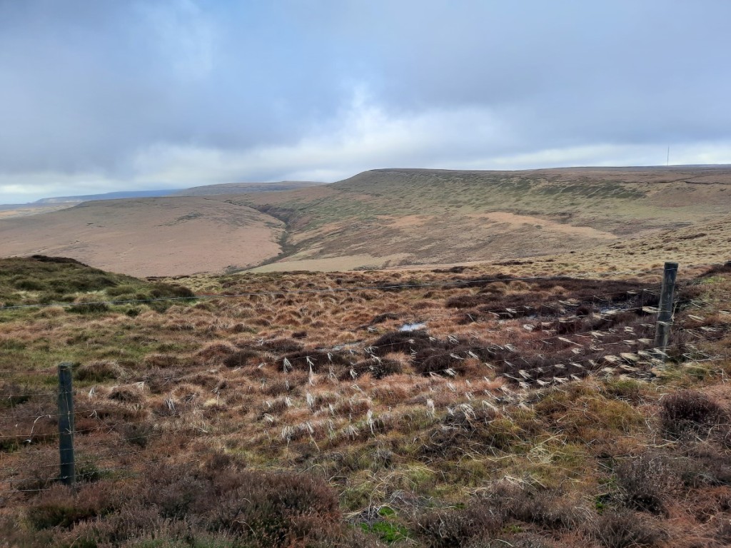
It was a perfect, blue-sky day with a good covering of snow at all levels. As we got our boots on, we decided that it was not worth carrying an ice axe or crampons as we would not be crossing any really steep ground and the snow would be fresh and soft. Soon we were heading up the Garburn Pass track, which provides an easy route to the ridge. Continuing gently up to Yoke, we found that in many places the wind had already scoured the path entirely of snow, and progress was consequently fairly easy, except through the occasional deep drift.

Kentmere valley

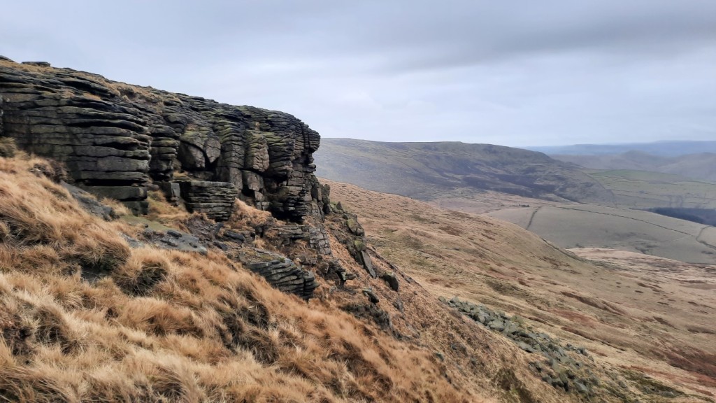
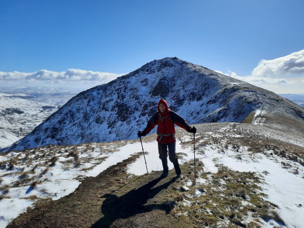
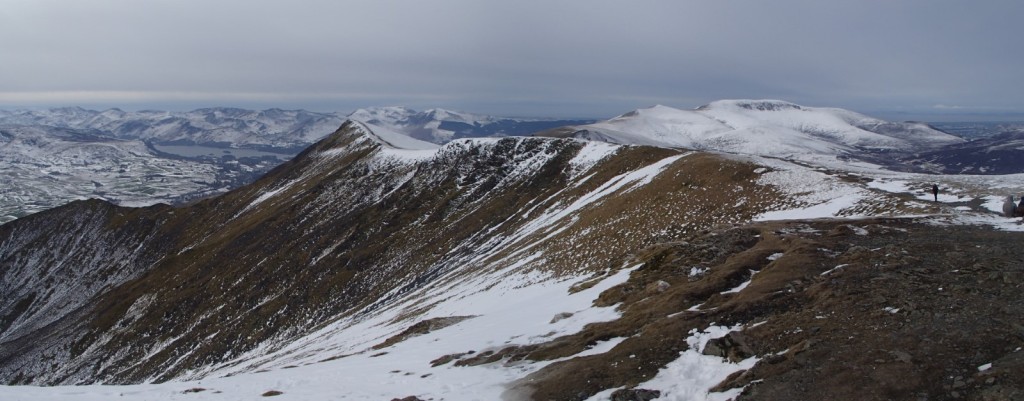
The ridge from Yoke to Thornthwaite Crag, via Ill Bell and Froswick, is one of my favourites in the Lake District, and did not disappoint. The light covering of snow nicely accentuated the crags, and with excellent visibility we could see clearly as far as the Coniston Fells, Langdale, Scafell Pike, Fairfield and Helvellyn to the west. We had first lunch in the disappointingly-ineffective shelter of Thornthwaite Beacon, not lingering on before getting moving again to warm up.

Looking north from Ill Bell to Froswick and Thornthwaite Crag
Mike on Froswick

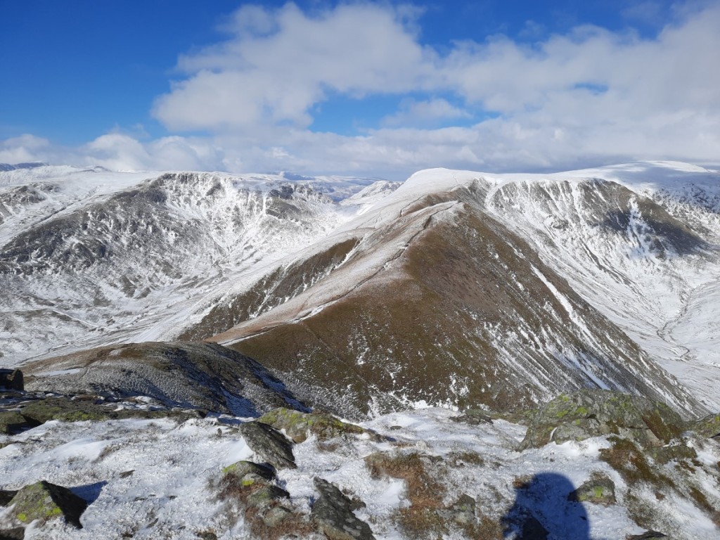
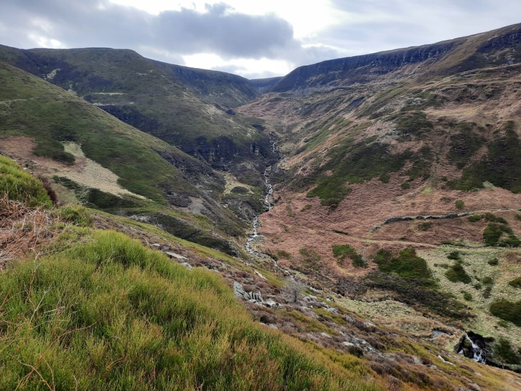
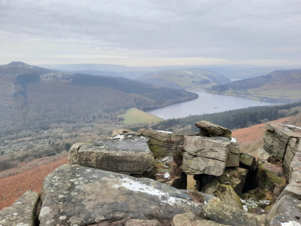
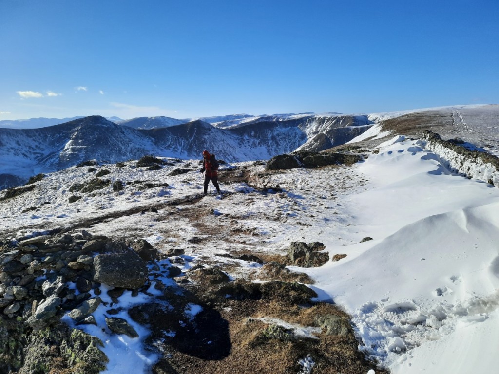
The next section of the walk, over the shoulder of High Street to Mardale Ill Bell, had the deepest snow covering of the day, with at least six inches most of the way and deeper drifts in places. As always, the views back to Ill Bell and its neighbours were magnificent. Crossing Nan Bield Pass to Harter Fell, we gained spectacular vistas north over Small Water and Haweswater, and paused in a relatively sheltered spot for second lunch.

Looking back to Yoke, Ill Bell and Froswick
Small Water and Haweswater
Looking over Small Water to High Street

I had expected more deep snow on the long, gentle ridge to Kentmere Pike and Shipman Knotts, but that proved not to be the case, with the stony path blown totally clear most of the way. Nevertheless, it felt like quite a long way down the ridge, particularly as we ended up taking a rougher line than intended down to the bridleway at Stile End. From there, it was just a couple of kilometres along the lanes back to Kentmere village. A perfect winter day in the sunshine!

Snowdrifts on Kentmere Pike, but little snow on the path

I dropped Mike back to his car in Staveley, then continued via Ambleside and Dunmail Raise to our accommodation for the weekend, the Blencathra Centre, above Threlkeld. Most of the others had already arrived. It was quite a luxurious bunkhouse, with small en-suite bedrooms and a comfortable lounge-dining area with panoramic views over the Vale of Keswick, Once I’d said my hellos and taken a few minutes to settle in and make my bed, a few of us set off down to Threlkeld for a hearty pub dinner at the Horse and Farrier. Once back at the bunkhouse, we had time for a glass of wine and some more chat before bed.

On Saturday, I offered to lead a walk around the horseshoe to Blencathra from Mungrisdale village. I was surprised that Mike was the only one to sign up, with many preferring to walk directly from the bunkhouse even though Howard’s route (also up Blencathra) was longer, and a few others heading to Skiddaw. Nevertheless, the two of us set out again, and I drove us the 15 minutes or so to our start point. We were not sure to what extent the partially-thawed snow at lower levels would have re-frozen into hard ice overnight, so opted to wear winter boots and carry crampons, although not ice axes. It turned out the snow remained soft at all levels and no winter gear was necessary.

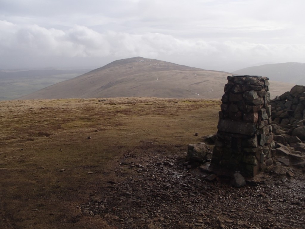
Our route started over Souther Fell, which always offers excellent views of Bannerdale Crags and Blencathra to the west – views in fact of our route for the rest of the day! I thought Souther Fell was a quiet hill but we found at least a couple of dozen others making their way along the ridge, so perhaps it has become a popular route. Deservedly so, in my opinion!

Bannerdale Crags

A gentle descent was followed by a long, gentle ascent over Scales Fell to the summit of Blencathra. This offered great views of Sharp Edge and Scales Tarn to the right, and improving views over the very snowy Dodds, less snowy Central Fells, and beyond, to the left. There was only the odd sunny spell, the weather being mostly overcast, but the air clarity was still excellent.

Looking over the Vale of Keswick
Scales Tarn
Looking towards Skiddaw

Turning north, we continued over Atkinson Pike then descended (with great views back to the snowy side of Sharp Edge) and reascended over easy ground to Bannerdale Crags, where we paused for lunch. The ridge onward to Bowscale Fell gave easy walking with a light covering of snow, before the final descent into Mosedale via the attractive Bowscale Tarn. That just left a couple of miles of easy track and road walking back to the car.

Looking back to Blencathra from Bannerdale Crags
Bowscale Tarn

We were the first back to the bunkhouse, so I was able to enjoy a couple of cups of tea and a shower before the others began to return. We enjoyed discussing our excellent, snowy days on the hill over the preparation and eating of dinner – spag bol for the carnivores. In common with the others, I got a fairly early night, but did not sleep well – not sure why!

On Sunday, I again offered to lead a walk, this time up the Ullock Pike ridge southwest of Skiddaw, but did not get any takers. So instead I joined Howard’s walk from Mosedale village over Carrock Fell and High Pike, in the northeastern corner of the Northern Fells, behind Blencathra. Mike, Marie, Simon and Jayne also came along, but unfortunately Jayne left her boots behind so she and Simon had to return to collect those and ended up doing a similar route separately, a little later.

Almost all the snow had melted with a rise in temperatures and some heavy rain overnight, so the ground around Bowscale Tarn (looking up the valley) had changed from white to brown. Howard led us up a small and attractive path that I didn’t know existed, directly up the end of Carrock Fell from the southeast. In the past I have always used the one marked on the map on the northeastern side. Winding through the heather and past a few sheepfolds, we soon reached the old fort at the summit.

Looking back down over Mosedale village

The winds were pretty ferocious in the immediate vicinity of the cairn, so we didn’t stop there, dropping down to the west and continuing along the flat ridge over Milton Hill. We had seen a couple of race marshals near the summit, and were soon being overtaken by the leaders in the Carrock Fell Race, and thereafter by progressively slower fellrunners further back in the sizeable field! I did not envy them racing in shorts and singlets in the strong, cold wind while I was comfortable in base layer, micro-fleece and two jackets!

When we reached the junction with the Cumbria Way, the others opted to skip the small detour to High Pike and head south directly. I thought I’d have a quick yomp up to the summit and back, and catch them back up on the descent. It proved a good decision as the mist lifted off the top as I ascended to leave good views in all directions, with even Blencathra and Skiddaw clearing for a bit.

Carrock Fell, from High Pike

I found the others having lunch in the ‘Lingy Hut’, a small MBA bothy on the side of Great Lingy Hill, offering welcome respite from the wind. Once we’d eaten, we continued down the Cumbria Way into Mosedale, past the old tungsten mines and down the lane to return to the cars. A little light rain fell in the final half hour, later than had been forecast, but wasn’t enough to make us significantly wet.

Lingy Hut, with Blencathra beyond

Having said my farewells, I drove an hour and a quarter or so to High Bentham to visit my parents for dinner and a chat. After that, the drive south was very wet but not delayed, and I was home by around 9:15pm.

Maps of my routes can be found at these links:
Kentmere Round
Blencathra
Carrock Fell
More photos are available on Google Photos here.

To sum up, another fantastic weekend in the hills with some welcome late-winter snow conditions. I look forward to the next Gentian meet, in the Brecon Beacons next month.

Birker Fell and Swaledale (3rd-5th March 2023)

Unusually, we both had empty diaries, so I took the opportunity to visit my sister for the weekend. As she wanted to avoid damaging a sore knee, Ruth didn’t want to do long walks, so there was plenty of time for me to fit in a tourist parkrun to start Saturday. The chosen location was Barrow, which was about 45 minutes’ drive from Ruth’s house. Walking into the park at around 8:45, it seemed surprisingly deserted and we began to wonder whether I had somehow missed a cancellation notice, but sure enough a few volunteers were lurking in the bandstand and other runners soon began to emerge. The park is near the town centre, so I suspect a lot of the runners come on foot and don’t feel the need to leave much slack time in their travel plans!

In the end, there were 131 participants. Buoyed by my first sub-20 run for months, two weeks ago on the flat tarmac of Alvaston, I was feeling optimistic for a good time, but doubted I’d be able to achieve that milestone again when I saw the significant hill from lake to war memorial, to be tackled three times. I pushed hard though, and was pleasantly surprised to keep my average pace below 4:00/km throughout and finish in 19:47, just 2 seconds slower than at Alvaston. Four speedy under-16s beat me, two of them in under 17 minutes! Ruth walked around and photographed me at a few locations around the compact course!

Lap 1 at Barrow parkrun, surprisingly already running alone!

Afterwards, we headed north to park at the summit of the Ulpha / Birker Fell road. I had only visited these quiet hills around Devoke Water once before, so it was good to renew my acquaintance. We made an anticlockwise loop around the lake, taking in the rocky summits of Rough Crag, Water Crag, White Pike and Yoadcastle, and enjoying the distant views of the Scafell massif to the northeast, as well as towards the coast.

Looking over Devoke Water into the Lake District
The summit of White Pike, with Yoadcastle in the background

The continuation over Hesk Fell, down to the pass (with a pause for lunch), and back up the other side to Great Worm Crag, was grassier and less steep, From there, it got more interesting again, and it was good to revisit the Wainwright, Green Crag, with its impressive summit tor. Three other pairs of walkers there were the only others we passed all day. Then it was just a short walk back to Birkerthwaite and the car.

Looking past Harter Fell to the Scafell range, from Green Crag
Setting off down from Green Crag

Once we were back in Natland, Ruth had some marking to do, so I gave her some peace and quiet and popped into Kendal to call on Ian and Emma. Great to catch up over a cup of tea, initially with Ian, then joined by Emma and the girls once they returned from a 4th birthday party.

On Sunday we decided to head to the Yorkshire Dales: in particular, to Swaledale, where Ruth had a couple of unbagged Nuttalls. Looking back, I find that I’ve only made one previous visit to that valley myself, on a CUHWC weekend trip 12 years ago to the day! The drive up, via Kirkby Stephen, took around an hour. We parked in a layby just outside the small village of Muker. Once booted up, we headed north up Swaledale and then steeply up the rocky gorge of Swinner Gill – definitely the highlight of the day.

Swaledale, above Muker
Swinner Gill

Once we’d gained the plateau, it was easy walking along tracks to Rogan’s Seat and then on a small path beside the fence to Water Crag, where we had lunch in the large and effective shelter cairn. The moorland views were extensive, north into the North Pennines and south over Swaledale. The terrain was pretty featureless and it didn’t look like the pathless valley from Wham Bottom would give easy walking, so we took a bearing SSE to the end of the bridleway at Blakethwaite, passing over fairly rough heather but surprisingly dry bogs.

Blakethwaite

The tracks down beside Gunnerside Gill gave more attractive walking, with natural limestone crags and various industrial remains from the once-extensive lead mining. There was a lot of lurid green grass and moss in the abandoned mining rakes, presumably affected by the minerals in the soil.

Industrial heritage by the old Blakethwaite Smelter
Fields and barns below Winterings Edge

The final stretch from Ivelet beside the river back to Muker gave an easy grassy finish to the day. We took the 500m detour north to the footbridge once we had confirmed that there was no easy crossing available on the direct path. I paused at Ruth’s for dinner before hitting the road for a quiet and undelayed drive back home. Great to revisit two quiet but pretty areas that I had only been to once before. And less than a week until my next trip to the Lake District!

Maps of our routes are available here (Birker Fell) and here (Rogan’s Seat), and more photographs here.

Black Hill (19th February 2023)

I took a trip to one of the furthest-away parts of the Peak District, aiming to tick off three of my four unbagged Ethels and explore the unfamiliar area east of Black Hill. It’s an off-putting 70 miles from home, but actually mostly on the A38 and M1 so only about 80 minutes’ drive. I parked near the sailing club at Winscar Reservoir, where the forecast of sunny spells first thing happily proved to be correct!

Winscar Reservoir

The moorland to the west is pretty much pathless on the OS map but I had used the Strava Global Heatmap to identify the most popular routes on the ground and this did give me paths most of the way, even if they were sometimes indistinct or boggy. I followed small trods beside the stream up Dearden Clough, then picked up the fence-line along Upper Dead Edge. There hadn’t been much of a view from the broad ridge, with Bleaklow in the cloud to the south, but on reaching the trig point (and Ethel summit) I was suddenly able to see down towards Woodhead and Crowden.

Looking down to Crowden from Dead Edge End

More interesting views over the steeper slopes of Withens Moor made the traverse to Britland Edge Hill (the next Ethel) more enjoyable. The wire fence was also unusually festooned with strands of wind-blown grass, fluttering in the strong westerly breeze.

Withens Moor and the wind-blown grass!

The next couple of kilometres to the road at Holme Moss were particularly boggy, so I was glad to reach the firmer ground beyond. I had only seen a pair of fellrunners up to this point, so I was surprised to find quite a few other walkers on the path up to Black Hill. Perhaps I should not have been surprised, as it’s the shortest and easiest route, even if not as well surfaced as the Pennine Way! Although the path was reasonably obvious, in the mist I was glad of the reassurance of a compass bearing after I’d passed the last real landmark at Heyden Head. With a cold breeze and no view at the summit, I didn’t hang around long before setting off north along the stone-pitched path beside Issue Clough. Once I’d descended a few metres, however, I was back in the clear, with sunlit views northeast towards Holmfirth, and my route down to the ‘Issues Road’ track became obvious.

Dropping back into the sunshine by Issue Clough

The track gave easy walking down to the hamlet of Holme, beyond which I picked up some popular footpaths beside Brownhill Reservoir – an attractive spot with steep, mixed woodlands all around. Once I’d crossed the dam of Ramsden Reservoir, I reascended towards Ramsden Edge and traversed above the woods into Ramsden Clough. There I paused for a late lunch on a very comfortable rock in the sunshine, with an excellent view over the reservoirs and up Ramsden Clough!

Brownhill Reservoir
Riding Wood Reservoir, from my lunch spot

After lunch, I continued up Ramsden and Ruddle Cloughs to gain the moorland plateau again, then followed a line of grouse butts up onto Snailsden Pike. From the western top, marked as higher on the map, I felt sure that the trig point further east was in fact higher, but looking back from the trig it was not so clear! Best to visit both to be sure of bagging the Ethel properly. A good path led down to Harden Reservoir dam, from where it was an easy walk on large tracks around the east side of Winscar Reservoir and back to the car.

Ramsden Clough
The spillway from Harden Reservoir into Winscar Reservoir

The Ethel summits themselves weren’t especially inspiring today, but my route back from Black Hill via Holme and Marsden Clough was very attractive, and this area would definitely be worth exploring more thoroughly. My remaining Ethel is Ashway Moss, near the Trinnacle, so that should give a good walk from Dovestone Reservoir later in the year.

More photos can be seen here, and a map of my route here.

Hayfield skyline (4th February 2023)

I haven’t been for a walk with Amina since 2020, so I was pleasantly surprised when she said recently that she’d be up for a day out in the Peak District. No parkrun for me, in order to be fresh for a longer race the following morning, so it was the ideal Saturday for a walk and the forecast of dry, overcast weather was alright too.

We met at my house soon after 9 o’clock and I drove us up to Hayfield – Amina was keen to see my new car – to start walking soon after 10:30. I had wondered whether the cloud would be on the tops to start off. That proved not to be the case so we walked clockwise to get to the highest ground sooner, heading past Kinder Reservoir and then up William Clough. The visibility was pretty good with clear views around the skyline, and towards Manchester and Bleaklow once we reached the ridge.

Looking over Kinder Reservoir dam towards Mount Famine
Amina in William Clough

We continued east along the edge of Sandy Heys, pausing for a brief first-lunch in the shelter of a gully and to take a few photos around Kinder Downfall.

Gritstone crags at Sandy Heys
Kinder Downfall

Another half hour or so brought us to the high point of the day, the trig point on Kinder Low. By this point, the cloud had started to drop a bit and Sandy Heys was in the mist although Kinder Low itself remained just about clear.

The summit of Kinder Low
Amina by Edale Rocks

We dropped down to Edale Cross for lunch in the most sheltered spot we could find, then continued along the path – well-pitched at first, then boggy – over the shoulder of Brown Knoll and down the ridge to South Head and Mount Famine. A bit of drizzle blew through in the wind and made us a little damp for quarter of an hour or so but petered out before we’d got around to putting on our waterproof jackets. All that remained was the easy descent down the bridleway to Coldwell Clough and the car.

Looking back to Kinder Scout from Mount Famine
Looking back up to South Head and Mount Famine from Coldwell Clough

A good day out on the hill and it was great to catch up with Amina as we walked and talked. Hopefully it won’t be another 2.5 years until the next time! You can find more photos here and a map of our route here.

Stanage, Derwent and Bamford Edges (22nd January 2023)

Looks like I missed the best weather of the weekend, having seen photos of a cracking day of inversions and sunshine in the Peaks yesterday, but nevertheless I headed up to Hathersage today for my first local walk of the year. It was a cold start, with temperatures on the drive ranging from -7.5°C to -5°C, but with light winds didn’t actually feel too chilly at any point on the walk.

I started by ascending to Carhead Rocks, somewhere I had not been before, which gave good views down to the Derwent Valley and up to Stanage Edge.

Carhead Rocks, with Stanage Edge above

I then continued up to Stanage and followed the edge north all the way to Moscar Lodge. There were quite a few people around initially, but it got much quieter further north. There was a little snow wherever the sun had not shone, but nothing was very slippery, and progress was easy, particularly with the peat all well frozen.

Orange skies to the south
A bit snowier near Stanage End

Once past Moscar, I headed northwest over Strines Edge – another new route for me – and across the heather moor to reach Derwent Edge near Dovestone Tor. Turning south, I followed the edge as far as Whinstone Lee Tor, enjoying the views over Ladybower and the various rock formations, then took the bridleway east to Cutthroat Bridge, where I paused for lunch in the warmth of the woods.

Ladybower, with Kinder beyond

A short climb back up via Jarvis Clough brought me onto Bamford Moor, and soon to the busy viewpoint of Bamford Edge. I escaped the crowds as I descended south, and returned to Hathersage via Gatehouse and Birley Farm.

The classic view from Bamford Edge
Looking down over Bamford

No real sunshine and fairly hazy views today, but it was good to get out in the Peaks in wintery conditions before the thaw comes later in the week.

There’s a map of my route here, and more photos here.

Gentian Rhyd Ddu Trip (13th-15th January 2023)

The Gentian Club’s first weekend trip of 2023 went to the Oread Club’s ‘Tan yr Wyddfa’ bunkhouse in Rhyd Ddu, west of Snowdon – a place I had stayed as an undergraduate with CUHWC. I have a few days of 2022 annual leave to use up by Easter, so I took the first of them on Friday to make it a three day weekend. I had advertised my intention to walk on Mynydd Mawr on the Friday, and Simon had decided to join me, and also offered me a lift from his home in Walsall. A pretty early start was required to get to his house around 7:45am for the three hour drive to west Wales. Google directed us around the traffic by recommending the scenic route via Bala and Trawsfynydd.

We parked in Nantlle village and were walking just before 11am, following the Slate Trail around the south side of Llyn Nantlle Uchaf and up the valley. We then zigzagged back left onto the ridge of Mynydd Mawr, enjoying dramatic views over the crags of Craig y Bera on the final section towards the summit. Sunny spells gave dramatic light conditions over all the surrounding peaks, although Snowdon was in cloud.

Snowdon and Yr Aran
Craig y Bera
Sunshine over the Nantlle Ridge

We descended northwest to cross the boggy bwlch and reach the minor summit of Moel Tryfan – a HuMP I had not previously visited. The hill is heavily scarred by disused and active slate quarries, but still gave good views. We then rejoined the Slate Trail for the return leg to Nantlle, finishing around 3:30pm.

The view from Moel Tryfan
Simon above Nantlle village

After a short drive east, we reached the bunkhouse slightly before the appointed arrival time of 4 o’clock to find a few others also just arriving. With a few attendees having dropped out in the preceding few days, the bunkrooms, lounge and dining area were fairly spacious for the ten of us, and the temperature gradually rose as the coal fire burned! I had fresh pasta for dinner before an evening of chat and a couple of glasses of wine.

On Saturday, I led a walk up Moel Hebog, for which I was joined by Simon, Petra, Sheena and Martin. The day had started fairly wet, but it was petering out by the time we set out from Rhyd Ddu, and a couple of light showers in the first half hour of walking were the sum total of rain during our walk. The skies gradually brightened as we followed the Slate Trail south through Beddgelert Forest towards Beddgelert. About 1km short of the village, we turned right to ascend the well-trodden path up onto Moel Hebog, with improving views towards Snowdon – which emerged from the cloud for an hour or so – Cnicht and the Moelwyns. We had lunch in the shelter of a small crag about two thirds of the way up, before the final steep climb between the crags to the ridge.

Yr Aran
Looking towards Cnicht and the Moelwyns

The summit gave great views both south to Porthmadog and north to the subsidiary tops of Moel yr Ogof and Moel Lefn, with the Nantlle Ridge. However, with a strong and cold wind, we didn’t linger long before starting the descent north. Once we were down at the bwlch, Martin opted to descend east from there back to the forest tracks, while the other four of us continued along the ridge. Short ascents with a little easy scrambling here and there led us up to each hill. The clouds generally got greyer and the wind strengthened noticeably, but there were still dramatic light conditions over the coast, seen best from Moel Lefn.

Descending from Moel Hebog
Moody skies over Moel Lefn
Looking out to the coast from Moel Lefn

A steep and fairly rough descent eventually brought us to the shelter of the forest, and easier walking on tracks and good paths back to Rhyd Ddu where we were glad of tea, cake and showers. In the evening, Simon cooked a tasty and filling beef casserole for the meat-eaters, followed by Petra’s bread and butter pudding.

Sunday started very wet, and with low cloud shrouding all the summits. Nevertheless, I trusted the forecast, which only predicted showers, and proposed a linear walk along the Nantlle Ridge, from west to east to have the wind behind us. Simon and Petra chose to join me, while the others mostly did a walk along the Slate Trail from Waunfawr back to Rhyd Ddu – part of which Simon and I had done on Friday.

Simon drove us to the start but, unfortunately, hit a large pothole hidden in a puddle near the top of the low pass, puncturing his front offside tyre. That meant a short stop to change the wheel in the cold rain before we could continue to our start point near Talysarn. The walk started on what turned out to be a very little-used footpath up through trees, undergrowth and a small quarry. It was good to reach the open land above, which gave easier walking with less careful navigation required!

Petra and Simon escaping the undergrowth above Talysarn

We passed the ruined cottage of Brynllidiard and continued up beside the crags of Cwm Silyn. Sadly the thick mist meant we couldn’t see the lakes in the combe below. A light shower blew through as we approached the summit of Craig Cwm Silyn, and I put my waterproofs on in the shelter of one of the large cairns. The descent to Bwlch Dros-bern proved to be the most awkward of the walk, thanks to the patchy covering of slushy snow on the boulders.

After the short but steep reascent to Mynydd Tal-y-mignedd, we paused for lunch at the summit, which was surprisingly sheltered – or perhaps the wind had just dropped – before continuing on the narrower sections of ridge to Trum y Ddysgl and Mynydd Drws-y-coed. Although we never dropped out of the mist, the terrain is interesting enough to be enjoyable even without a view. Soon we had reached the easier ground of Y Garn, which just left the descent of the eroded path back to Rhyd Ddu.

The summit of Mynydd Tal-y-mignedd
Mynydd Drws-y-coed

We were the first back, at least an hour before the slower-moving group on the Slate Trail, so made a good start on the cleaning and tidying while we waited. Unfortunately, Petra had inadvertently left her car keys in Simon’s car, so we were unable to collect it from Talysarn until the other drivers arrived back from their walk to rescue us! In the end, Simon and I set off home around 6pm and had a smooth journey back to Walsall, and then (for me) on to Hilton.

Overall, three good days on the hill with great company. Weather-wise, we got away pretty lightly considering the forecast each day had been for strong winds and heavy showers. Most of the heaviest rain fell overnight, and we had had summit views on two days out of three. I look forward to the next weekend trip, to the North Lakes in March.

My full photo album is available on Google Photos here.

Route maps are available at the following links:
Mynydd Mawr
Moel Hebog
Nantlle Ridge

RRDB (not)Butlins weekend in Ironbridge (6th-8th January 2023)

Usually, the weekend after New Year, a few of us from Rolls-Royce (Derby) Band take a trip to Butlins in Skegness for a social weekend at the annual Mineworkers Contest. However, there was no contest held this year, so I organised an alternative, “(not)Butlins” weekend away. The destination was Ironbridge, where we stayed in the spacious and well-equipped YHA hostel at Coalbrookdale.

As the lead booker, I felt I ought to arrive promptly on the Friday afternoon, so I got an early finish from work at around 2:30pm, picked up Becky from Littleover, and drove down to arrive in Ironbridge around 4pm – a surprisingly smooth journey for a Friday afternoon. Jeff and Helen had arrived a few minutes earlier and opened up. They had volunteered to lead the group catering, so we helped them unload the groceries into the large commercial kitchen before getting the kettle on and starting some advance food preparations for Saturday dinner. The others – 21 of us in total – arrived over the course of the evening and we had a sociable evening over dinner and a few drinks.

Saturday began with most of us heading to the nearby Telford parkrun. Fortunately, fairly heavy rain as we drove into town began to ease by around 8:45am and had fully stopped by the time the race briefing was underway, so we avoided a soaking! The course was comprised of two laps, one short and one long, mostly on tarmac, with a significant downhill to start and, of course, a significant uphill back up to the finish. I was first finisher from our group (as usual), but Tim’s run, around 90 seconds slower than mine, achieved by far the highest age grade, just over 70%. I strolled back down to the bottom of the hill to run back up with Heather D offering ‘encouragement’. She and several others ran good times. Afterwards, we got coffee and cakes at Costa before returning to the hostel.

Team photo after parkrun: Jane, Tim, Heather H, Hayley, Ashleigh, Jake, Meg, Heather D, Becky, Helen, Jeff, me, Will and Janine.

For the afternoon, I led some of the group on a walk up The Wrekin, while the others went for a sightseeing stroll by the bridge and river. We took the main path up from the east, enjoying clear views in all directions in the sunny spells. It was dramatic to see the flooded River Severn below, with the main Shropshire hills beyond. We continued along the ridge to descend to the lane to the west, then took lower-level tracks around the south side of the hill back to the cars.

Setting off from the summit of The Wrekin
Descending the steep west ridge

We were back at the hostel by teatime to shower and change before a big effort to prepare the group dinner under Helen’s leadership. After the meal, the evening continued with drinks and games in the lounge until late.

Sunday started with a full cooked breakfast together, after which we cleaned up and packed away all our stuff into the cars to check out by 10am. A few headed home or to other commitments, while most of us returned to the Ironbridge riverside for a stroll and/or coffee at a café. After that, we headed to the Exotic Zoo, close to where parkrun had been held in the Town Park, to potter around looking at the animals before another café stop for lunch before the drive home.

The Iron Bridge

In summary, a well-attended and very enjoyable social / team-building weekend away for the band before our main preparations begin for the Midlands Championships at the end of February. Perhaps, if the Butlins contest doesn’t resume, we’ll do something similar again next year.

There are a few photos here, and a map of our route up The Wrekin here. Telford parkrun results are here!

Kinlochleven (27th December 2022 – 2nd January 2023)

For this year’s New Year trip to the Highlands, we had booked an Airbnb cottage in Kinlochleven, which would give us good access to the Mamores and the Glen Coe hills. In order that he and Ruth could take their bikes, and to have plenty of room for luggage and provisions in general, Josh drove us up in his van this year. The drive went well, without major delay, pausing for a supermarket shop and lunch at Morrison’s in Dumbarton. The roadsides were pretty snowy through the Highlands, but the road itself was clear.

Lots of snow at the top of Glen Coe

The cottage was attractively located right at the top of the village, giving views down the loch with the Corbetts of Garbh Bheinn and Mam na Gualainn either side. Soon we had unpacked the shopping, settled into our rooms and prepared dinner for the night. We had read reviews saying the cottage was chilly in winter, but the electric heating actually proved more than capable of keeping the place cosy, with or without the assistance of the woodburning stove.

Wednesday seemed to have the best forecast of the first three days, so we elected to get out at dawn for a walk in the Mamores, fairly similar to one I’d done three years previously when Ruth and I were staying in Glencoe village, but in the opposite direction and following different ridges up and down. We started alongside the Grey Mare’s Tail waterfall before gaining the grassy south ridge of Na Gruagaichean, earning ever-improving views over Loch Leven and towards Am Bodach as we climbed.

Loch Leven

At about 900m, we decided the snow was hard enough for crampons to be worthwhile – the long-awaited first use for Josh’s pair that had been carried in vain on numerous previous outings! We were in and out of the mist on the final approach to the summit, but had views enough of the time to get a good impression of the dramatic surroundings.

The ridge to Na Gruagaichean

A fairly steep descent and reascent led us to the NW Top of Na Gruagaichean, perhaps a better viewpoint than the main summit. Then it was much easier walking along the broader, gentler ridge to Stob Coire a’ Chairn, with great views of An Gearanach close-by, and the Nevis range in the distance.

Na Gruagaichean NW Top, and Aonach Beag across the glen
Am Bodach, Sgurr a’ Mhaim and Ben Nevis, from Na Gruagaichean NW Top
Ben Nevis and Carn Mor Dearg, from Stob Coire a’ Chairn

The traverse to Am Bodach was narrower and steeper again, and very enjoyable in the snow. The clouds dropped a bit as we made the final ascent to deprive us of a summit view though. We descended by the SE ridge towards Sgurr an Fhuarain, but dropped off southwest well before that minor top to follow a snowy gully down into the valley – much more pleasant than the rough heather either side. We ran out of snow at around 500m, so took our crampons off there before continuing down to meet the West Highland Way which led us back to Kinlochleven.

Am Bodach

The cloud was lower on Thursday, and a few showers were forecast, but it seemed better than Friday at least. We chose to head to a Graham, Druim na Sgriodain, on the far side of the Corran Ferry. Foot passengers go free, so we parked at the east side of the ferry, which drops you right where you need to be for this hill anyway.

The first couple of kilometres were north along the lochside road as far as the burial ground at Cille Mhaodain. From there, it was a steep ascent up fairly easy grassy terrain to gain the ridge of Sgurr na h-Eanchainne. This offered good views into Ardgour and back down to Loch Linnhe.

Looking into Ardgour
Loch Linnhe

The peak had been clear as we ascended, but was in cloud by the time we got there, so we didn’t linger long before continuing west and southwest on compass bearings past various lochans to reach the Graham summit, 4 metres higher than the more shapely Sgurr.

Ruth and Josh by a frozen lochan on Druim na Sgriodain

Descending the ridge to Meall Breac, we soon dropped back into the clear. A slightly awkward descent down a steep grassy gully brought us safely between the crags into the bottom of Coire Dubh, from where a small path led more easily down beside the waterfall of Maclean’s Towel to a transmitter mast. The sun was coming out, giving attractive views over the loch and towards Beinn a’ Bheithir. Easy tracks led the rest of the way back to the ferry.

Sunset over Loch Linnhe, from beside Maclean’s Towel

On Friday, more persistent rain was forecast. Ruth and Josh were tired and opted for a cycle ride around Loch Leven, while I headed up the nearby Corbett, Garbh Bheinn. On my previous visit, I had taken the standard route up the west ridge, so this time the east ridge would give some variety. The rain was light but persistent as I set off up the hydro tracks into Coire Mhorair, so I soon paused to put on full waterproofs.

Coire Mhorair

Once I’d reached the small reservoir at 160m, I turned more steeply up the grassy slopes to the west, and made steady but tiring progress up through increasingly-deep snow to the East Top. The Mamores to the north were mostly in cloud, but the Aonach Eagach to the south stayed clear, providing dramatic views to my left. After a short pause for a snack and to put on an extra layer, I continued up the broad, snowy ridge to the Corbett summit, which gave closer views of the craggiest parts of the Aonach Eagach, and also down the loch to the Pap of Glencoe.

Pap of Glencoe and Mam na Gualainn
Looking towards the Mamores
Snowy Aonach Eagach

I returned to Kinlochleven by the same route, the light rain never really stopping or getting heavy enough to give me a soaking, and my footprints (the only ones) making the navigation quick and straightforward! On reaching the cottage, I was surprised to find Ruth and Josh just setting out for a stroll up to a nearby waterfall, having abandoned their cycling plan due to the rain being too heavy. Clearly it had been worse in the valley than on the hill!

Saturday, New Year’s Eve, had the best weather forecast of the trip, with light winds and high cloud predicted. But we were pleasantly surprised when we got up to see that the skies were in fact cloudless! This confirmed our intention to have a go at a circuit of Bidean nam Bian, one of the more challenging peaks in Glen Coe. It was about half an hour’s drive to the start point at the Three Sisters viewpoint, where we set off a bit before sunrise but in good light. The path down to the river and up the other side into Coire Gabhail – the ‘Lost Valley’ – was mostly dry and unexpectedly ice-free, making for easy progress.

Ascending into Coire Gabhail, with views across Glen Coe

Once we’d escaped the narrow gorge, it didn’t take long to cross the flat, rocky bed of the hanging valley above and reach the snowline. After a short detour up the wrong side of the river to realise we were separated from the path by an uncrossable gully, we retraced our steps a short distance to get back on track and continue up through ever-deepening and steepening snow. The crust at lower levels was mostly firm enough to take my weight and Ruth’s, but not so often Josh’s!

Coire Gabhail, the ‘Lost Valley’

There were clearly no rocky obstacles on the route up the snow all the way to the bealach at the head of the corrie, but we could not really tell whether there was a significant cornice to cross there. I led the way, breaking the trail and kicking steps where needed! Ruth put crampons on part-way up, and Josh and I followed suit a bit later. The final section was as steep as I’m comfortable ascending without a rope, but the snow was pleasantly solid and it never felt like the foot or ice-axe placements might give way. The final metre or so turned out to be a softer cornice, but not quite vertical, and solid enough to climb over the top rather than having to cut a route through. It had been tiring work though, and I was relieved to reach the easy flat ground above, particularly when the views in all directions were such a magnificent reward! I took a few photographs and offered what advice I could as Josh and then Ruth followed me up.

Ruth and Josh, high in Coire Gabhail
Josh checking on Ruth’s progress
Ruth approaching the final cornice

Once we’d all gathered our breath and had some refreshments, we continued the walk up the easy (but very snowy) ridge to the first Munro, Stob Coire Sgreamhach. This was a super viewpoint over the two Buachailles to the east, and back over the bealach to Sgurr na h-Ulaidh and Bidean nam Bian itself.

Coire Gabhail, from Stob Coire Sgreamhach
The view of Sgurr na h-Ulaidh and Bidean nam Bian
Ruth and Josh on Stob Coire Sgreamhach, with the Buachailles in the background

We returned to the bealach then ascended easily the other side to reach the main summit of Bidean, revealing more incredible views over Stob Coire nam Beith to the west. We were amazed that nobody else had come up that day, our footprints being the only blemish in the deep, pristine snow.

Heading for Bidean, with views of Sgurr na h-Ulaidh
Looking back to Stob Coire Sgreamhach
Approaching Bidean nam Bian

The ridge onward to Stob Coire nan Lochan had the deepest snow yet, a little softer where it had accumulated on the north side of the hill, but didn’t provide any real obstacles to progress. Soon we were at that final Top, where we met a climber who had just come up by one of the easier gullies on the north side. It turned out there were quite a few climbers there, although none had made the continuation to Bidean.

Stob Coire nan Lochan
Me, Ruth and Josh on Stob Coire nan Lochan, looking back to Bidean

It did mean we had plenty of tracks to follow for a quick descent down into Coire nan Lochan to gain the path back down into Glen Coe. An enjoyable end to perhaps the best winter day I’ve had in the Highlands. In the evening, we enjoyed Toad in the Hole and Sticky Toffee Pudding for our Hogmanay dinner, but were tired from a bit day and decided not to stay up to see in the new year.

Stob Coire nam Beith, as we descended

On New Year’s Day, it looked like the best of the weather would be on the coast, so we picked the two Munros of Beinn a’ Bheithir as our objective. We started in Ballachulish and set off south up Gleann an Fhiodh. Light rain fell to start with, but soon petered out to nothing, and it stayed dry from then on. A well walked path leads up onto the ‘Schoolhouse Ridge’, the NE ridge of Sgorr Bhan.

Loch Leven below

We gained height steadily in just a thin covering of fairly grippy snow, and after a while reached the scrambly section. The crux step proved to be quite a major obstacle in winter conditions! Josh clambered up with some difficulty in his boots, and recommended that Ruth and I put our crampons on before attempting to follow. Ruth’s regular climbing experience helped her get up too, but I was less confident, chickened out and took an easier line by grassy ledges around the south side instead. From there on, the route was more straightforward, the rocky steps having a better covering of snow on the ledges which thus felt a lot more secure under the crampons!

Ruth on Schoolhouse Ridge

We had entered the cloud part way up, and didn’t get any unrestricted views as we continued along the ridge, slightly down and back up to the first Munro, Sgorr Dhearg, then more significantly down and back up to the second, Sgorr Dhonuill.

Approaching the summit of Sgorr Dhonuill

There we met two men whose footsteps we had been following since the summit of Sgorr Bhan, and chatted briefly before they continued. We had lunch on the summit, then returned to the bealach and descended easy snow slopes to the north into the corrie. Ruth found a small, well-built path that avoided the boggy ground and felled forestry on the book route. Then the final few kilometres were an easy march, gently downhill on forest tracks back to the village.

On Tuesday, we sadly had to head home. It was a sunny morning, so we had lots of awesome views to enjoy as we drove back up Glen Coe and over Rannoch Moor to Crianlarich and along Loch Lomond. Conditions got steadily less snowy as we continued south through the Southern Uplands, and there was barely any snow in sight in the English hills of the North Pennines and Lake District. The final drive home from Ruth’s house to Derby wasn’t a good one, with significant bank holiday traffic clogging the M6, but I made it eventually and without incident, with a few hours spare to get the laundry and unpacking sorted before bed and the return to work.

In summary, five excellent, contrasting days on the hill. I revisited seven Munros and a Corbett, and bagged one new Graham. Very atypically of recent New Year trips, the wind was never strong and the rain never heavy! The crampons and ice axe saw more use than they have for years, with quality winter days on the Mamores and Beinn a’ Bheithir, and of course the undoubted highlight of that perfect New Year’s Eve walk up Bidean.

Maps of our routes are available at the following links:
Na Gruagaichean to Am Bodach
Druim na Sgriodain
Garbh Bheinn
Bidean nam Bian
Beinn a’ Bheithir

My full photo album can be found here.